Nsiika, Uganda

Last updated
Nsiika
Uganda location map.svg
Red pog.svg
Nsiika
Location in Uganda
Coordinates: 00°17′45″S30°20′36″E / 0.29583°S 30.34333°E / -0.29583; 30.34333
Country Flag of Uganda.svg Uganda
Region Western Uganda
District Buhweju District
Elevation
5,200 ft (1,600 m)

Nsiika is a town in Buhweju District, in Western Uganda. It is the main municipal, administrative and commercial center in Buhweju District, and is the location of the district headquarters. [1]

Contents

Location

Nsiika is located approximately 53 kilometres (33 mi), by road, northwest of Mbarara, the largest city in the sub-region. [2] This is approximately 310 kilometres (190 mi), by road, southwest of Kampala, the capital of Uganda and the largest city in that country. [3] The coordinates of Nsiika are: 0°20'53.0"S, 30°26'04.0"E (Latitude:-0.348056; Longitude:30.434444). [4]

Overview

The population of the town of Nsiika is not publicly known, but as of 31 October 2013, there were 1,046 registered voters in Nsiika Town Council. [5]

The town attained town council status in 2010 when Buhweju became a district. The town faces my challenges, including lack of tarmac road, lack of a sewerage system, absence of a central garbage disposal system and absence of a centralized electricity grid. However, about 93 percent of the town inhabitants have access to piped water. [6]

Points of interest

The following points of interest lie within the town limits or near the edges of town:

See also

Related Research Articles

<span class="mw-page-title-main">Mbarara district</span> District in Western Uganda, Uganda

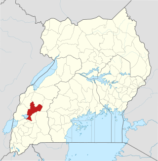
Mbarara District is a district in South Western Uganda. In 2019, the Ugandan Cabinet approved part of Mbarara District, the then-Mbarara municipality, to be upgraded to city status effective July 2020.

Kanungu is a town in the Western Region of Uganda. It is the location of the district headquarters for Kanungu District.

<span class="mw-page-title-main">Uganda Martyrs University</span> Private university in Uganda

Uganda Martyrs University (UMU) is a private University affiliated with the Roman Catholic Church in Uganda. The University is owned by the Episcopal Conference of the Catholic Bishops of Uganda. It is licensed by the Uganda National Council for Higher Education. UMU consists of seven Faculties, two Institute, six Campuses, nine Departments, and three schools. As of March 2022, total student enrollment is 4,632. Of these, about 1,500 students were residential, while nearly 3,000 students were enrolled in UMU's distance learning programs. The number of staff members was over 400.

Kiruhura is a town in the Western Region of Uganda. It is the largest town in Kiruhura District and the site of the district headquarters.

Sheema, also Sheema Municipality, is an urban centre in the Western Region of Uganda. It is the largest municipality in Sheema District.

Ishaka is a town in the Western Region of Uganda. It is one of the municipalities in Bushenyi District.

<span class="mw-page-title-main">Buhweju District</span> District in Western Uganda, Uganda

Buhweju District is a district in Western Uganda. It is one of the districts that constitute the Ankole sub-region. Its 'chief town', is Nsiika.

Kibingo is a town in Western Uganda. It is the location of the district headquarters of Sheema District.

Kitagata is a town in Western Uganda. It is one of the urban centers in Sheema District.

Bugoye is a small town in Western Uganda.

Nyakahita is a sparsely populated settlement in the Western Region of Uganda.

Kazo is a town in the Western Region of Uganda. It is the capital of Kazo District.

The Masaka–Mbarara Road is a road in the Central and Western Regions of Uganda, connecting the cities of Masaka in Masaka District, Central Region and Mbarara in Mbarara District, Western Region.

Rubanda is a town in the extreme southwest of the Western Region of Uganda. It serves as the commercial, political and administrative center of Rubanda District.

Rukiga District is a district in Western Uganda. Its capital is Mparo. However, the largest urban center in the district is Muhanga.

Bihanga is a settlement in Ibanda District in the Western Region of Uganda. It is the location of the headquarters of Bihanga Parish, Nyamarebe sub-county.

Lwensinga is a town in the Buganda Region of Uganda.

Bugongi is a town in the Western Region of Uganda. It is an urban center in Sheema District.

NSSF Mbarara Complex, also Mbarara City House, is a building in Mbarara, a city in the Western Region of Uganda.

<span class="mw-page-title-main">Kitagwenda District</span> Ugandan district

Kitagwenda District is a district in Western Uganda. The district is named after Kitagwenda County, which is coterminous with the district.

References

  1. Tumushabe, Alfred (24 September 2016). "Buhweju: Beautiful but unlucky". Daily Monitor . Kampala. Retrieved 17 January 2018.
  2. Globefeed.com (17 January 2018). "Distance between Mbarara, Western Region, Uganda and Nsika, Uganda". Globefeed.com. Retrieved 17 January 2018.
  3. Globefeed.com (17 January 2018). "Distance between Post Office Building, Kampala Road, Kampala, Uganda and Nsika, Uganda". Globefeed.com. Retrieved 17 January 2018.
  4. Google (17 January 2018). "Location of Nsiika, Buhweju District, Western Region, Uganda" (Map). Google Maps . Google. Retrieved 17 January 2018.
  5. CCEDU (31 October 2013). "CCEDU Observes the Buhweju By-election Statement". Ccedu.org (CCEDU). Retrieved 17 January 2017.
  6. Namazzi, Elizabeth (9 November 2013). "Buhweju's Nsiika can even do better". New Vision . Kampala. Retrieved 17 January 2018.
  7. Barigaba, Julius (27 August 2011). "Politics of patronage: Gold-rich Buhweju struggling for revenue". The EastAfrican . Kampala. Retrieved 17 January 2018.

00°17′45″S30°20′36″E / 0.29583°S 30.34333°E / -0.29583; 30.34333