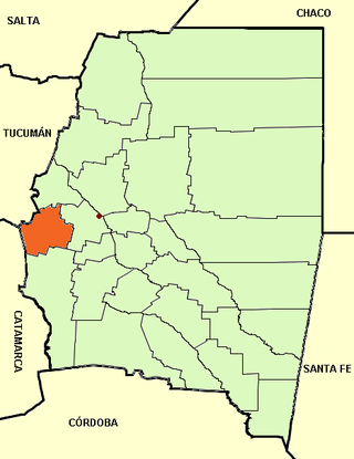
Guasayán Department is a departamento of the province of Santiago del Estero, Argentina.

Departments form the second level of administrative division, and are subdivided in municipalities. They are extended in all of Argentina except for the Province of Buenos Aires and the Autonomous City of Buenos Aires, the national capital, each of which has different administrative arrangements.

San Vicente is a town and administrative centre of San Vicente Partido, in the province of Buenos Aires, Argentina. The southernmost town in the Greater Buenos Aires metropolitan area, San Vicente is 48 km (30 mi) from downtown Buenos Aires, and can be accessed from Constitución Station by bus via Line 79 or a 20-minute drive by Provincial Route 58 from Ezeiza International Airport. The city has about 21,000 inhabitants per the 2001 census [INDEC].
Tostado is a city in the northwest of the province of Santa Fe, Argentina, 334 km (208 mi) north-west from the provincial capital. It had about 14,000 inhabitants at the 2010 census [INDEC] and it is the head town of the Nueve de Julio Department.

The Nueve de Julio Department is an administrative subdivision (departamento) of the province of Santa Fe, Argentina. It is located in the northwestern corner of the province, limiting with the Vera Department in the east, and with the San Cristóbal Department in the south. To the north it limits with the province of Chaco, and to the west with the province of Santiago del Estero.

La Banda is a city in the province of Santiago del Estero, Argentina. It has about 95,000 inhabitants as per the 2001 census [INDEC], making it the second largest in the province. It is the head town of the Banda Department.
Bernardo de Irigoyen is a city in the province of Misiones, Argentina. It has 10,889 inhabitants as per the 2001 census [INDEC], and is the head town of the General Manuel Belgrano Department. It carries the name of prominent politician and diplomat Bernardo de Irigoyen.
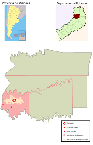
Eldorado is a city in the center-northeast of the province of Misiones, Argentina. It has 54,189 inhabitants as per the 2001 census [INDEC], making it the third most populated city in the province, and is the head town of the Eldorado Department. It is located on the left-hand (eastern) banks of the Upper Paraná River, on National Route 12, about 100 km from the Iguazú Falls and 206 km from the provincial capital Posadas, on the Argentina-Paraguay border.

Nueve de Julio is a department of Chaco Province in Argentina.
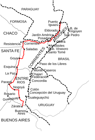
National Route 12 (RN12) is a road in Argentina, connecting the northeast section to the rest of the country. It runs through the provinces of Misiones, Corrientes, Entre Ríos and Buenos Aires.
Villa Aberastain is an Argentine city of the province of San Juan, head of the department Pocito, and the headquarters of the municipal authorities of the department. Villa Aberastain is within the so-called Valley of Tulum, the main agricultural oasis in the province is concentrated and where 90% of the provincial population. The village is located about 15 kilometres from the low foothills of the Great St. John. National Route No. 40 passes a few kilometres east of the town and communicates with the provincial capital and the city of Mendoza.

Nueve de Julio is a department of Argentina, located in the south-center of the province of San Juan. Lying within the Tulum Valley agricultural oasis, almost 80% of the department's area is cultivated; it is known in particular for its production of wine and its fruit and vegetable crops.

Rinconada is a rural municipality and village in Jujuy Province in Argentina. It is located in the west of the province of Jujuy and is the head of the Rinconada Department.

Frías is a city in Argentina, located southwest of the province of Santiago del Estero, near the border with the province of Catamarca, and is the head of the Choya Department. It is located on the banks of the river Albigasta at coordinates: 28 ° 38'60 "S 65 ° 09'05" W.
Alba Posse is a village and municipality in Misiones Province in north-eastern Argentina.

Azara is a village and municipality in Misiones Province in north-eastern Argentina. It is considered an agricultural colony, having about 230 km2. The municipality is located in the Apóstoles department, bordered by the municipalities of Apóstoles and Tres Capones in the same department, by the Sierra de Concepción in the Concepción Department and by the province of Corrientes.

Campo Grande (Misiones) is an Argentine locality in the province of Misiones, the head of the Cainguás department. It borders the municipality of Aristóbulo del Valle, of the same department, and the municipalities of Ruiz de Montoya in the Libertador General San Martín department, Jardín América in the San Ignacio department, Campo Viera and Campo Ramón in the Oberá department, and those of 25 de Mayo and Alba Posse in the 25 de Mayo department.

El Soberbio is a village and municipality in Misiones Province in northeastern Argentina. It contains the 25,690 hectares Papel Misionero Natural Cultural Reserve, created in 1994.

General Urquiza is a village and municipality in Misiones Province in north-eastern Argentina. It is located within the department San Ignacio. The town runs from the coast of Paraná River and the National Road No. 12. General Urquiza is located on the coast of Paraná and settled the major population centers: Puerto Menocchio, Port of Spain, Puerto Lapacho and Gisela Cologne. However, the decline in the use of the river as a transport medium promoted the formation of a settlement located just 1.5 miles of Route 12, in what is known as Barrio Industrial and building housing the municipality of General Urquiza. For this reason this settlement is now known as General Urquiza. According to the 2001 census, the population center is only the latter, the others being considered as dispersed rural population.

Barrio San Pedro Pescador is a village and municipality in Chaco Province in northern Argentina, located on the thin coastal levee of the Paraná River. The town is located in the Primero de Mayo Department and reports administratively to the Colonia Benitez municipality. It occupies the left side of the Chaco end of the General Manuel Belgrano Bridge, which links the province of Chaco with the city of Corrientes. The low-lying and floodable characteristics of the right bank of the Parana River are not conducive for human settlement, San Pedro Pescador being Chaco's only urban settlement located on the main channel of this river. Paradoxically the Parana River is the main source of livelihood (fishing) and its main threat, because of the periodic floods that force temporary abandonment by its inhabitants.


