
Nuoro is a city and comune (municipality) in central-eastern Sardinia, Italy, situated on the slopes of the Monte Ortobene. It is the capital of the province of Nuoro. With a population of 36,347 (2011), it is the sixth-largest city in Sardinia.

Sardinia is the second-largest island in the Mediterranean Sea, after Sicily, and one of the 20 regions of Italy. It is located west of the Italian Peninsula, north of Tunisia and immediately south of the French island of Corsica.
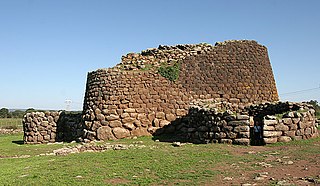
The nuraghe, or also nurhag in English, is the main type of ancient megalithic edifice found in Sardinia, developed during the Nuragic Age between 1900 and 730 B.C. Today it has come to be the symbol of Sardinia and its distinctive culture known as the Nuragic civilization. More than 7,000 nuraghes have been found, though archeologists believe that originally there were more than 10,000.
Porto Torres is a comune and a city of the Province of Sassari in north-west of Sardinia, Italy. Founded during the 1st century BC as Colonia Iulia Turris Libisonis, it was the first Roman colony of the entire island. It is situated on the coast at about 25 kilometres (16 mi) east of Capo del Falcone and in the center of the Gulf of Asinara. The port of Porto Torres is the second biggest seaport of the island, followed by the port of Olbia. The town is very close to the main city of Sassari, where the local university takes office.
Abbasanta is a town and comune in the province of Oristano, Sardinia (Italy). It is located on the main road between Macomer and Oristano.

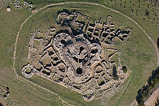
Su Nuraxi is a nuragic archaeological site in Barumini, Sardinia, Italy. Su Nuraxi simply means "The Nuraghe" in Campidanese, the southern variant of the Sardinian language.
Paulilatino is a comune (municipality) in the Province of Oristano in the Italian region Sardinia, located about 100 kilometres (62 mi) northwest of Cagliari and about 25 kilometres (16 mi) northeast of Oristano.

The Nuragic civilization, also known as the Nuragic culture, was a civilization or culture on Sardinia (Italy), the second largest island in the Mediterranean Sea, which lasted from the 18th century BC up to the Roman colonization in 238 BC. Others date the culture as lasting at least until the 2nd century AD and in some areas, namely the Barbagia, to the 6th century AD or possibly even to the 11th century AD.

The Torrean civilization was a Bronze Age megalithic civilization that developed in Southern Corsica, mostly concentrated south of Ajaccio, during the second half of the second millennium BC.

The Giants of Mont'e Prama are ancient stone sculptures created by the Nuragic civilization of Sardinia, Italy. Fragmented into numerous pieces, they were discovered in March 1974 on farmland near Mont'e Prama, in the comune of Cabras, province of Oristano, in central-western Sardinia. The statues are carved in local sandstone and their height varies between 2 and 2.5 meters.

The Nuraghe La Prisgiona is a nuragic archaeological site, located in the Capichera valley in the municipality of Arzachena Costa Smeralda in the north of Sardinia. It consists of a nuraghe and a village comprising around 90–100 buildings, spread across 5 hectares. Findings from this site are in many cases unique in Sardinia, particularly with regard to decoration and use. Due to the large extent and number of buildings the site is considered unique in North-East Sardinia. There is also some evidence for occupation during Roman and medieval times. The Giants' grave Coddu Vecchiu is located nearby.

The Nuraghe Arrubiu is one of the largest nuraghes in Sardinia. It is located in Orroli, in the province of South Sardinia. Its name means "red Nuraghe" in the Sardinian language, which derives from the basalt stones it had been built with.

The nuraghe Seruci is an important archaeological site, located in the municipality of Gonnesa, in the Iglesiente region of Sardinia.

The nuraghe Palmavera is an archaeological site located in the territory of Alghero, Sardinia. It is classified as a complex nuraghe, that consists of several towers joined together. The nuraghe and the surrounding village were built in various phase during the Bronze Age and the Iron Age.

The nuraghe Is Paras is an archeological site of Isili, a town in the historical region of Sarcidano, province of South Sardinia.

The Nuraghe Antigori is a nuragic complex dating back to the second millennium BC. It's located in the municipality of Sarroch, in the Metropolitan City of Cagliari.
The nuraghe Genna Maria is an archaeological site in the comune of Villanovaforru, province of South Sardinia.

The Nuragic sanctuary of Santa Vittoria is an archaeological site located in the municipality of Serri, Sardinia – Italy. The name refers to the Romanesque style church built over a place of Roman worship which rises at the westernmost tip of the site. The Santa Vittoria site was frequented starting from the first phase of the Nuragic civilization corresponding to Middle Bronze Age. Subsequently, from the late Bronze Age to the early Iron Age, the place became one of the most important expressions of the Nuragic civilization and today it constitutes the most important Nuragic complex so far excavated.

Nuraghe Su Mulinu is an archaeological site located in the territory of Villanovafranca, in the province of South Sardinia.

