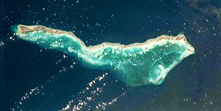
Tabiteuea is an atoll in the Gilbert Islands, Kiribati, farther south of Tarawa. This atoll is the second largest and the most populated of the Gilbert Islands after Tarawa. The atoll consists of one main island, Aanikai in the north, and several smaller islets in between along the eastern rim of the atoll. The atoll has a total land area of 38 km2 (15 sq mi), while the lagoon measures 365 km2 (141 sq mi). The population numbered 5,261 in 2015. The islanders have customary fishing practices related to the lagoon and the open ocean.

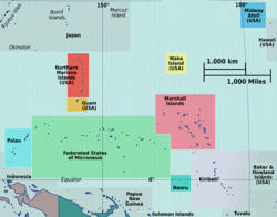
Air Kiribati is the flag carrier of the Republic of Kiribati and operates scheduled passenger services to 20 atolls spread over an area of 3.5 million square kilometres (1,400,000 sq mi).

Abemama (Apamama) is an atoll, one of the Gilberts group in Kiribati, and is located 152 kilometres southeast of Tarawa and just north of the Equator. Abemama has an area of 27.37 square kilometres and a population of 3,299 as of 2015. The islets surround a deep lagoon. The eastern part of the atoll of Abemama is linked together by causeways making automobile traffic possible between the different islets. The outlying islands of Abatiku and Biike are situated on the southwestern side of the atoll.

Beru is an atoll in the Southern Gilbert Islands in the Pacific Ocean, part of the Republic of Kiribati. Beru was previously known as Eliza, Francis Island, Maria, Peroat, Peru Island or Sunday. It's part of a larger reef with the Nuka Lagoon at its center, and the nearest island is Nikunau. The Tabiang Lagoon is present in the north. Beru is home to 2,051 inhabitants. Due to sea surges, the atoll is experiencing coastal erosion along with damages to seawalls.

Nonouti is an atoll and district of Kiribati. The atoll is located in the Southern Gilbert Islands, 38 km north of Tabiteuea, and 250 km south of Tarawa. The atoll is the third largest in the Gilbert Islands and is the island where the Roman Catholic religion was first established in Kiribati, in 1888.
Utiroa is a settlement in Kiribati. It is located on Tabiteuea atoll and is the capital of North Tabiteuea; Nuribenua is to its west, while Terikiai and Eita are to its north.
Terikiai is a settlement in Kiribati. It is located on an atoll; to its west are Nuribenua, Tanaiang, and Te Kapuipui, and to its east are Eita and Utiroa.
Tanaeang is a settlement in Kiribati. It is located on Tabiteuea atoll; to its west is Nuribenua, while Eita and Terikiai lie to the east.
Air Tungaru was the first airline of Kiribati. As the predecessor of current Air Kiribati, it was Kiribati's national flag carrier. Air Tungaru's main base was the international airport at Kiribati's capital, South Tarawa. From there, regular service was provided to all 16 domestic airports in the Gilbert Islands.

The Battle of Drummond's Island was a conflict between the United States Exploring Expedition and the village of Utiroa on April 1841 at Drummond's Island, Tabiteuea North, which is now part of Tabiteuea. The cause of the conflict was the disappearance of the American seaman John Anderson, who was suspected, with no evidence, to have been murdered by the village natives. In retaliation, the members of the expedition killed twelve of the natives and burned the village of Utiroa to the ground.
North Tabiteuea is a local council in Tabiteuea, Kiribati.
Kabuna is a village on Tabiteuea atoll in Kiribati. There are 202 residents of the village. The nearest village is Taumwa to the north; and Tanaatoorua to the south. Apart from small breaks, the whole coastline from on the lagoon side is eroding as the result of wave action.
Aanikai is the main island of North Tabiteuea, in Kiribati.
Tekaman is a place on the main island Nuribenua of the Tabiteuea atoll in the Gilbert Islands of the island state Kiribati in the Pacific Ocean. He belongs to the district North Tabiteuea. In 2017, the place had approx. 244 inhabitants.
Tekabwibwi is a place on the main island Nuribenua at the north end of the Tabiteuea atoll in the Gilbert Islands of the island state Kiribati in the Pacific Ocean. It belongs to the district North Tabiteuea. In 2017, the place had approx. 162 inhabitants.
Kabuna is a Motu and a place in the north of the Tabiteuea atoll in the Gilbert Islands of the island state Kiribati in the Pacific Ocean. It belongs to the district North Tabiteuea. In 2017, the place had approx. 151 inhabitants.
Tauma is a Motu and a place in the north of the Tabiteuea atoll in the Gilbert Islands of the island state Kiribati in the Pacific Ocean. It belongs to the district North Tabiteuea. In 2017, the place had approximately 211 inhabitants.
Taungaeaka is a Motu and a place in the south of the Tabiteuea atoll in the Gilbert Islands of the island state Kiribati in the Pacific Ocean. It belongs to the district South Tabiteuea. In 2017, it had 158 inhabitants.
Nikutoru is a place at the southern end of the Tabiteuea atoll in the Gilbert Islands of the island state Kiribati in the Pacific Ocean. He belongs to the district South Tabiteuea. In 2017, the place had approx. 155 inhabitants.
Aiwa is a Motu and a place in the center of the Tabiteuea atoll in the Gilbert Islands of the island state Kiribati in the Pacific Ocean. He belongs to the district North Tabiteuea. In 2017, the place had approx. 125 inhabitants.