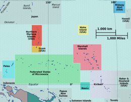
Kiribati, officially the Republic of Kiribati, is an island country in the Micronesia subregion of Oceania in the central Pacific Ocean. Its permanent population is over 119,000 as of the 2020 census, with more than half living on Tarawa atoll. The state comprises 32 atolls and one remote raised coral island, Banaba. Its total land area is 811 km2 (313 sq mi) dispersed over 3,441,810 km2 (1,328,890 sq mi) of ocean.

The Gilbert Islands are a chain of sixteen atolls and coral islands in the Pacific Ocean, about halfway between Papua New Guinea and Hawaii. They constitute the main part of the nation of Kiribati.
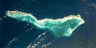
Tabiteuea is an atoll in the Gilbert Islands, Kiribati, farther south of Tarawa. This atoll is the second largest and the most populated of the Gilbert Islands after Tarawa. The atoll consists of one main island, Aanikai in the north, and several smaller islets in between along the eastern rim of the atoll. The atoll has a total land area of 38 km2 (15 sq mi), while the lagoon measures 365 km2 (141 sq mi). The population numbered 5,261 in 2015. The islanders have customary fishing practices related to the lagoon and the open ocean.

Air Kiribati is the flag carrier of the Republic of Kiribati and operates scheduled passenger services to 20 atolls spread over an area of 3.5 million square kilometres (1,400,000 sq mi).

Abemama (Apamama) is an atoll, one of the Gilberts group in Kiribati, and is located 152 kilometres southeast of Tarawa and just north of the Equator. Abemama has an area of 27.37 square kilometres and a population of 3,299 as of 2015. The islets surround a deep lagoon. The eastern part of the atoll of Abemama is linked together by causeways making automobile traffic possible between the different islets. The outlying islands of Abatiku and Biike are situated on the southwestern side of the atoll.

Beru is an atoll in the Southern Gilbert Islands in the Pacific Ocean, part of the Republic of Kiribati. Beru was previously known as Eliza, Francis Island, Maria, Peroat, Peru Island or Sunday. It's part of a larger reef with the Nuka Lagoon at its center, and the nearest island is Nikunau. The Tabiang Lagoon is present in the north. Beru is home to 2,051 inhabitants. Due to sea surges, the atoll is experiencing coastal erosion along with damages to seawalls.

Nikunau is a low coral atoll in the Gilbert Islands that forms a council district of the Republic of Kiribati. It consists of two parts, with the larger in the northwest, joined by an isthmus about 150 metres (490 ft) wide.

Nonouti is an atoll and district of Kiribati. The atoll is located in the Southern Gilbert Islands, 38 km north of Tabiteuea, and 250 km south of Tarawa. The atoll is the third largest in the Gilbert Islands and is the island where the Roman Catholic religion was first established in Kiribati, in 1888.
The Roman CatholicDiocese of Tarawa and Nauru in Kiribati and Nauru is a suffragan diocese of the Archdiocese of Suva. It was erected as the Vicariate Apostolic of Gilbert Islands in 1897, with see in Tanaeang from 1936 to the end of 1950s, and later elevated to as the Diocese of Tarawa in 1966. There was a name change in 1978 and, in 1982, the diocese was split from the Mission sui iuris of Funafuti. The diocese currently has jurisdiction over all of Kiribati and Nauru.
Utiroa is a settlement in Kiribati. It is located on Tabiteuea atoll and is the capital of North Tabiteuea; Nuribenua is to its west, while Terikiai and Eita are to its north.
Nuribenua is the largest island of Tabiteuea atoll in Kiribati; It includes the old Capital village of the atoll Terikiai, and the new capital village Utiroa . To its south are Tauma and Kabuna islands. To its north is Nonouti Atoll.
Terikiai is a settlement in Kiribati. It is located on an atoll; to its west are Nuribenua, Tanaiang, and Te Kapuipui, and to its east are Eita and Utiroa.
The Baháʼí Faith in Kiribati begins after 1916 with a mention by ʻAbdu'l-Bahá, then head of the religion, that Baháʼís should take the religion to the Gilbert Islands which form part of modern Kiribati. The first Baháʼís pioneered to the island of Abaiang, on March 4, 1954. They encountered serious opposition from some Catholics on the islands and were eventually deported and the first convert banished to his home island. However, in one year there was a community of more than 200 Baháʼís and a Baháʼí Local Spiritual Assembly. Three years later the island where the first convert was sent to was found to now have 10 Baháʼís. By 1963 there were 14 assemblies. As the Ellice Islands gained independence as Tuvalu and the Gilbert Islands and others formed Kiribati, the communities of Baháʼís also reformed into separate institutions of National Spiritual Assemblies in 1981. The Baháʼís had established a number of schools by 1963 and there are still such today - indeed the Ootan Marawa Baháʼí Vocational Institute being the only teacher training institution for pre-school teachers in Kiribati. All together the Baháʼís now claim more than 10,000 local people have joined the religion over the last 50 years and there are 38 local spiritual assemblies.
Air Tungaru was the first airline of Kiribati. As the predecessor of current Air Kiribati, it was Kiribati's national flag carrier. Air Tungaru's main base was the international airport at Kiribati's capital, South Tarawa. From there, regular service was provided to all 16 domestic airports in the Gilbert Islands.

The Battle of Drummond's Island was a conflict between the United States Exploring Expedition and the village of Utiroa on April 1841 at Drummond's Island, Tabiteuea North, which is now part of Tabiteuea. The cause of the conflict was the disappearance of the American seaman John Anderson, who was suspected, with no evidence, to have been murdered by the village natives. In retaliation, the members of the expedition killed twelve of the natives and burned the village of Utiroa to the ground.

North Tarawa or in Gilbertese Tarawa Ieta, in the Republic of Kiribati, is the string of islets from Buariki at the northern tip of Tarawa atoll to Buota in the South, with a combined population of 6,629 as of 2015. It is administratively separate from neighbouring South Tarawa, and is governed by the Eutan Tarawa Council (ETC), based at Abaokoro.
Octave Marie Terrienne MSC was the Roman Catholic bishop of the apostolic vicariate of the Gilbert Islands from 1937 until 1961, when Pierre Guichet succeeded him.
Aanikai is the main island of North Tabiteuea, in Kiribati.