
The City of Stockholm is situated on fourteen islands and on the banks to the archipelago where Lake Mälaren meets the Baltic Sea. The city centre is virtually situated on the water.

Östermalm is a 2.56 km2 large district in central Stockholm, Sweden. With 71,802 inhabitants, it is one of Sweden's most populous and exclusive districts. It is an expensive area, having the highest housing prices in Sweden.

Kungsträdgården is a park in central Stockholm, Sweden. It is colloquially known as Kungsan.
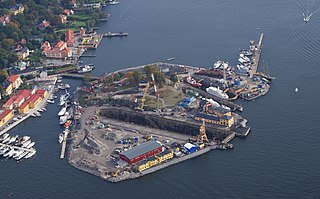
Beckholmen is a small island in central Stockholm, Sweden. Having served the city's shipping industry for centuries, Beckholmen is now regarded as a historical monument of national interest, and, by its location just south of Djurgården in the vicinity of other similar localities it also forms part of Royal National City Park, and Stockholms Sjögård, an area of the harbour of Stockholm containing maritime environments of historical interest.
Nybroplan is a public space in central Stockholm, Sweden. Located on the border between the city districts Norrmalm and Östermalm, Nybroplan connects a number of major streets, including Birger Jarlsgatan, Strandvägen, Hamngatan, and Nybrogatan. The squares Norrmalmstorg, Stureplan, and Östermalmstorg are located within 500 metres, as is the park Kungsträdgården.

Berzelii Park is a small park in central Stockholm, Sweden. The park is the location of the China Theater (Chinateatern), and the Berns Salonger Restaurant and Theater.

Strandvägen is a street on Östermalm in central Stockholm, Sweden. Completed just in time for the Stockholm World's Fair 1897, it quickly became known as one of the most prestigious addresses in town.
Skeppsholmsbron is in central Stockholm, Sweden, connecting Blasieholmen to Skeppsholmen.

Stadshusbron, formerly known as Nya Kungsholmsbron is a bridge in central Stockholm, Sweden located just north of the Stockholm City Hall. Stretching over Klara sjö, it connects mainland Norrmalm on the eastern shore to the island Kungsholmen on the western shore.
Skeppsbron is both a street and a quay in Gamla stan, the old town of Stockholm, capital of Sweden, stretching from the bridge Strömbron in front of the Royal Palace southward to Slussen.

Djurgårdsbrunnsviken is a bay in central Stockholm, Sweden, together with the canal Djurgårdsbrunnskanalen forming the northern shore line of the island Djurgården. The bridge Djurgårdsbron stretches over the bay.

Lillsjön is a small, former lake in Norra Djurgården, a semi-rural area in north-eastern central Stockholm, Sweden, forming part of the Royal National City Park. Today transformed into a wetland, it is often mentioned as one of the six lakes in the area, the other being: Laduviken, Uggleviken, Isbladskärret, Lappkärret, and Spegeldammen.

Uggleviken is a former bay and lake in Norra Djurgården, a semi-rural area in north-eastern central Stockholm, Sweden, forming part of the Royal National City Park.

South Harbour is a bay and harbour area immediately next to the centre of the city of Helsinki, Finland. 4.7 million passengers in liner traffic and some 37 000 international cruise passengers travel through it every year. Also over million tonnes of unitized cargo passes through the South Harbour. Most of the harbour's traffic is to Stockholm, Sweden and Tallinn, Estonia, and cruises. In summertime, there is also much small ship traffic. During the winter time, excess snow from snow removal may be disposed of in the harbor. As of 2020, the Carmel, an old vessel, was keeping the harbor open by circling 400 times within 24 hours.

Nybrogatan is a street in the borough of Östermalm in central Stockholm, Sweden. Approximately one kilometre in length, it stretches north from Nybroplan to Valhallavägen.

Klara sjö is a canal in central Stockholm, Sweden.

Barnhusviken is a body of water in central Stockholm, Sweden. Separating the island Kungsholmen from the mainland district Norrmalm north of it, it connects Karlbergssjön to Klara Sjö.
Norr Mälarstrand is a street on Kungsholmen in central Stockholm, Sweden. Bordering Riddarfjärden, the easternmost bay of Lake Mälaren, Norr Mälarstrand is a southbound boulevard stretching 1,4 km (4.500 ft) west from the Stockholm City Hall to the southern end of the street Sankt Eriksgatan. The most notable structures along the street are the series of functionalist residential buildings lined-up along its western part. The park facing the waterfront south of the street is popular for walks.
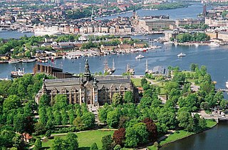
Djurgården or, more officially, Kungliga Djurgården, is an island in central Stockholm, Sweden. Djurgården is home to historical buildings and monuments, museums, galleries, the amusement park Gröna Lund, the open-air museum Skansen, the small residential area Djurgårdsstaden, yacht harbours, and extensive stretches of forest and meadows. It is one of the Stockholmers' favorite recreation areas and tourist destinations alike, attracting over 10 million visitors per year, of which some 5 million come to visit the museums and amusement park. The island belongs to the National City park founded in 1995. Since the 15th century the Swedish monarch has owned or held the right of disposition of Royal Djurgården. Today, this right is exercised by the Royal Djurgården Administration which is a part of the Royal Court of Sweden.

The following outline is provided as an overview of and topical guide to Stockholm:

