
Nyngan Parish is a civil parish of Robinson County, [1] a cadastral division of New South Wales. [2] It is located on Yanda Creek and the Kidman Way north east of Cobar, New South Wales.
It is west of the town of Nyngan, New South Wales.
Nyngan Parish is a civil parish of Robinson County, [1] a cadastral division of New South Wales. [2] It is located on Yanda Creek and the Kidman Way north east of Cobar, New South Wales.
It is west of the town of Nyngan, New South Wales.
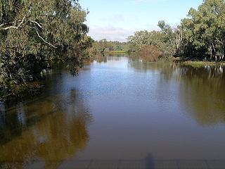
Bogan River, a perennial river that is part of the Macquarie–Barwon catchment within the Murray–Darling basin, is located in the central west and Orana regions of New South Wales, Australia.

Gregory County is one of the 141 Cadastral divisions of New South Wales. It is bordered by Bogan River in the west, and includes the area to the northeast of Nyngan. It includes the Macquarie Marshes Nature Reserve, and the town of Quambone.

Oxley County, New South Wales is one of the 141 Cadastral divisions of New South Wales. It is located between the Bogan River on the west, and the Macquarie River on the east. This is the area approximately between Warren and Nyngan.

Grahway is a bounded rural locality, and cadastral parish, 100 kilometers south of Nyngan, New South Wales. It is located at 32°12′05″S 146°38′31″E on Gunningbar Creek near the junction with the Bogan River and is in Bogan Shire and Flinders County. The locality is 32 kilometers south of the town of Nymagee, and west of Tottenham, New South Wales.
Wharfdale is a bounded rural locality, and cadastral parish south of Nyngan and west of Tottenham, New South Wales.

Merilba, New South Wales is a cadastral parish of Kennedy County New South Wales.
Willanbalang, New South Wales is a cadastral parish of Kennedy County New South Wales.
Nyngan Parish, New South Wales is a rural locality of Bogan Shire and a civil parish of Oxley County, New South Wales. a Cadastral divisions of New South Wales.
Wera Parish, New South Wales is a rural locality of Bogan Shire and a civil parish of Oxley County, New South Wales, a Cadastral divisions of New South Wales.
The Plains Parish, New South Wales is a rural locality of Bogan Shire and a civil parish of Oxley County, New South Wales, a Cadastral divisions of New South Wales.
Mudall Parish, New South Wales is a rural locality of Bogan Shire and a civil parish of Oxley County, New South Wales, a Cadastral divisions of New South Wales.
Cajildry Parish, New South Wales is a rural locality of Warren Shire and a civil parish of Oxley County, New South Wales, a Cadastral divisions of New South Wales.
Kungerbil Parish, New South Wales is a rural locality of Bogan Shire and a civil parish of Oxley County, New South Wales, a Cadastral divisions of New South Wales.
Mullengudgery Parish, New South Wales is a rural locality of Bogan Shire and a civil parish of Oxley County, New South Wales, Cadastral divisions of New South Wales.
Mumblebone, New South Wales is a rural locality of Warren Shire and a civil parish of Gregory County, New South Wales, a Cadastral divisions of New South Wales.
Billabulla, New South Wales is a rural locality of Warren Shire and a civil parish of Gregory County, New South Wales, a Cadastral divisions of New South Wales.
Beardina Parish, New South Wales is a rural locality of Warren Shire and a civil parish of Oxley County, New South Wales, a Cadastral divisions of New South Wales.
Carual, New South Wales also known as Carval is a civil parish and rural locality of New South Wales located at 31°37'54.0"S 147°44'04.0"E.
Egelabra, New South Wales is a civil parish and rural locality of New South Wales located at 31°47′54″S 147°50′04″E.
Gilgoen Parish is a civil parish of Gregory County, New South Wales.
Coordinates: 31°24′57.0″S145°59′00.0″E / 31.415833°S 145.983333°E
| This New South Wales geography article is a stub. You can help Wikipedia by expanding it. |