
Rognan is a village and the administrative centre of the municipality of Saltdal in Nordland county, Norway. The village is located at the innermost part of Skjerstad Fjord, called Saltdal Fjord. It is located about 15 kilometres (9.3 mi) north of the village of Røkland.

Blåmannsisvatnet is a lake in Fauske Municipality in Nordland county, Norway. The 3.76-square-kilometre (1.45 sq mi) lake lies on the southeast edge of the large Blåmannsisen glacier, about 35 kilometres (22 mi) east of the town of Fauske. The border with Sweden is located about 6 kilometres (3.7 mi) east of the lake.
Fiskeløysvatnet or Fisklausvatnet (Norwegian) or Guoledisjávrre (Lule Sami) is a lake that lies in the municipality of Saltdal in Nordland county, Norway. The 2.28-square-kilometre (0.88 sq mi) lake is located inside Junkerdal National Park, about 2 kilometres (1.2 mi) south of the border with Fauske Municipality.
Kjelvatnet (Norwegian) or Giebbnejávrre or Giebnejávri (Lule Sami) is a lake in Fauske Municipality in Nordland county, Norway. The 3.85-square-kilometre (1.49 sq mi) lake lies about 7 kilometres (4.3 mi) south of the village of Sulitjelma near the border with Junkerdal National Park. Water flows into the lake from the large lake Balvatnet and it flows out of the lake to the north along the Balmi River to the lake Langvatnet.
Langvatnet is a lake that lies in Fauske Municipality in Nordland county, Norway. The 5.46-square-kilometre (2.11 sq mi) lake lies about 25 kilometres (16 mi) east of the town of Fauske. The village of Sulitjelma lies on the northeastern edge of the lake. Water from the lakes Kjelvatnet and Låmivatnet flow into the lake from the south and east. The water from Langvatnet flows out through the Sjønstå River to the west towards the lake Øvrevatnet.
Låmivatnet or Loamevatnet (Norwegian) or Loamejávrre (Lule Sami) is a lake in Fauske Municipality in Nordland county, Norway. The 11.43-square-kilometre (4.41 sq mi) lake lies about 5 kilometres (3.1 mi) east of the village of Sulitjelma, just south of the Sulitjelma Glacier and north of Junkerdal National Park. The border with Sweden is 3 kilometres (1.9 mi) east of the lake. The Lomi Hydroelectric Power Station uses the lake as a reservoir.
Muorkkejávrre (Lule Sami) or Eidevatnet or Eidvatnet (Norwegian) is a lake that lies in Fauske Municipality in Nordland county, Norway. The 5.94-square-kilometre (2.29 sq mi) lake lies about 75 metres (246 ft) west of the border with Sweden and about 10 kilometres (6.2 mi) east of the village of Sulitjelma. The water from the lake flows west into the neighboring lake Låmivatnet. The ending -jávrre is the Lule Sami word for "lake".
Nedrevatnet or Nervatnet is a lake that lies in Fauske Municipality in Nordland county, Norway. The 4.8-square-kilometre (1.9 sq mi) lake lies just east of the town of Fauske. The lake Øvrevatnet flows into this lake and the water flows out of the Nedrevatnet into the Skjerstad Fjord. The European route E06 highway and the Nordland Line run along the western edge of this lake.
Øvrevatnet or Øvervatnet is a lake that lies in Fauske Municipality in Nordland county, Norway. The lake lies about 6 kilometres (3.7 mi) east of the town of Fauske. The 10.98-square-kilometre (4.24 sq mi) lake flows out into the neighboring lake Nedrevatnet to the west.

Straumsnes or Strømsnes is a village in the municipality of Fauske in Nordland county, Norway. It is located in the Valnesfjord area of Fauske. The town of Fauske lies 15 kilometres (9.3 mi) to the east and the town of Bodø lies about 40 kilometres (25 mi) to the west. The village sits just inland of Skjerstad Fjord, along the southern shore of the lake Valnesfjordvatnet.

Straumen is the administrative centre of Sørfold Municipality in Nordland county, Norway. The village is located at the end of the Sørfolda fjord, along the European route E06 highway. The lake Straumvatnet lies on the southeastern side of the village and the town of Fauske lies about 12 kilometres (7.5 mi) to the southwest.

The Sulitjelma Line was a railway line that ran between Finneid in the town of Fauske to the village of Sulitjelma near the border with Sweden. The railway line was entirely inside the municipality of Fauske in Nordland county, Norway. The line was built in 1891, over time it was lengthened until 1958 when it was connected to the Nordland Line and the sea port at Finneid. It existed as a branch of the Nordland Line from 1958 until 1972 when the line was closed and removed. The railway line followed the path of the present-day Norwegian County Road 830.

Sulitjelma (Norwegian), Sulisjielmmá (Lule Sami), or Sulitelma (Swedish) is a village in the municipality of Fauske in Nordland county, Norway. Sulitjelma is situated in a lush inland valley at an elevation of 140 metres (460 ft) above sea level. It is located on the shore of Langvatnet lake, about 35 kilometres (22 mi) southeast of the town of Fauske. The lakes Låmivatnet, Kjelvatnet, and Muorkkejávrre are located to the east and south of the village.

Sjunkhatten National Park was established in 2010 in Nordland county, Norway. The park consists of a 417.5-square-kilometre (161.2 sq mi) continuously protected area, including 39.8-square-kilometre (15.4 sq mi) sea area in the municipalities of Bodø, Fauske, and Sørfold. The park is located on a peninsula between the Sørfolda fjord and Saltfjorden, including glacier-formed landscape, caves and water systems, fjords, the large lake Heggmovatnet, rare animal species, and cultural heritage.
Suliskongen is a mountain in the municipality of Fauske in Nordland, Norway. The 1,908-metre (6,260 ft) tall mountain is part of the Sulitjelma massif and it is the second highest mountain in Northern Norway. It is located about 17 kilometres (11 mi) east of the village of Sulitjelma and the peak of the mountain lies less than 900 metres (3,000 ft) west of the border with Sweden. The Sulitjelma Glacier lies on the mountain.
Venset is a village in the municipality of Fauske in Nordland county, Norway. Venset lies on the north shore of Skjerstad Fjord about 17 kilometers (11 mi) west of the town of Fauske and about 6 kilometres (3.7 mi) south of the village of Valnesfjord.
The Balmi River is a river in the municipality of Fauske in Nordland county, Norway. It flows about 6.5 km (4.0 mi) from one lake and empties into another: from Kjelvatnet at an elevation of 510 meters (1,670 ft) north to Langvatnet at an elevation of 127 meters (417 ft). The river has a drainage basin of 439 square kilometers (169 sq mi). The river is located a short distance south of the village of Sulitjelma and about 35 kilometres (22 mi) southeast of the Fauske.
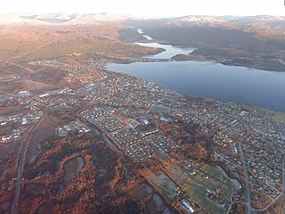
Fauske is a town in Fauske Municipality in Nordland county, Norway. It is also the administrative centre of Fauske Municipality. The town is located on the shore of the Skjerstad Fjord, about 60 kilometres (37 mi) east of the town of Bodø and about 40 kilometres (25 mi) west of the border with Sweden. The lake Nervatnet lies on the southeast side of the town.


