Shams Palace is a large estate designed by Taliesin Associated Architects on instructions from princess Shams Pahlavi, elder sister of Mohammad Reza Pahlavi, the last Shah of Iran. It was built in the early 1970s and it is located in Mehrshahr near Karaj, Iran.

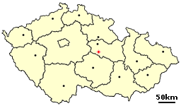
Mladoňovice is a village in the Pardubice Region of the Czech Republic. It has around 350 inhabitants.

Essig is a village in the municipality of Swisttal in Rhein-Sieg county in the German state of North Rhine-Westphalia. It is situated approximately 18 km southwest of Bonn. In 2007 it had a population of 428. The village hall of the municipality of Swisttal is located between Essig and its neighbouring village, Ludendorf.
Csincse is a village in Borsod-Abaúj-Zemplén county, Hungary.

Gać is a village in the administrative district of Gmina Oława, within Oława County, Lower Silesian Voivodeship, in southwestern Poland. It lies approximately 7 kilometres (4.3 mi) southeast of Oława, 36 kilometres (22 mi) southeast of the regional capital Wrocław, and has a population of 449. Prior to 1945 it was a part of Germany.
Pasieki is a village in the administrative district of Gmina Narewka, within Hajnówka County, Podlaskie Voivodeship, in north-eastern Poland, close to the border with Belarus.

Bronówek is a village in the administrative district of Gmina Wartkowice, within Poddębice County, Łódź Voivodeship, in central Poland. It lies approximately 10 kilometres (6 mi) west of Wartkowice, 10 km (6 mi) north-west of Poddębice, and 45 km (28 mi) north-west of the regional capital Łódź.

Łaziska-Kolonia is a village in the administrative district of Gmina Łaziska, within Opole Lubelskie County, Lublin Voivodeship, in eastern Poland. It lies approximately 3 kilometres (2 mi) south of Łaziska, 7 km (4 mi) south-west of Opole Lubelskie, and 50 km (31 mi) west of the regional capital Lublin.

Szczukowice is a village in the administrative district of Gmina Piekoszów, within Kielce County, Świętokrzyskie Voivodeship, in south-central Poland. It lies approximately 4 kilometres (2 mi) east of Piekoszów and 8 km (5 mi) west of the regional capital Kielce.

Kolonia Łapczyna Wola is a village in the administrative district of Gmina Kluczewsko, within Włoszczowa County, Świętokrzyskie Voivodeship, in south-central Poland. It lies approximately 8 kilometres (5 mi) north of Kluczewsko, 17 km (11 mi) north of Włoszczowa, and 53 km (33 mi) west of the regional capital Kielce.

Piasek is a village in the administrative district of Gmina Grębów, within Tarnobrzeg County, Subcarpathian Voivodeship, in south-eastern Poland. It lies approximately 2 kilometres (1 mi) east of Grębów, 15 km (9 mi) east of Tarnobrzeg, and 61 km (38 mi) north of the regional capital Rzeszów.
Polkowo is a village in the administrative district of Gmina Stoczek, within Węgrów County, Masovian Voivodeship, in east-central Poland.

Grzegorzowice is a village in the administrative district of Gmina Rudnik, within Racibórz County, Silesian Voivodeship, in southern Poland. It lies approximately 7 kilometres (4 mi) north-east of Rudnik, 10 km (6 mi) north of Racibórz, and 55 km (34 mi) west of the regional capital Katowice.

Trzebiec is a village in the administrative district of Gmina Tychowo, within Białogard County, West Pomeranian Voivodeship, in north-western Poland. It lies approximately 9 kilometres (6 mi) south-west of Tychowo, 18 km (11 mi) south-east of Białogard, and 117 km (73 mi) north-east of the regional capital Szczecin.

Sławęcice is a village in the administrative district of Gmina Szczecinek, within Szczecinek County, West Pomeranian Voivodeship, in north-western Poland. It lies approximately 20 kilometres (12 mi) north of Szczecinek and 143 km (89 mi) east of the regional capital Szczecin.
Komarivka is a village (selo) in Brody Raion, Lviv Oblast, in western Ukraine.
Pankova is a village (selo) in Brodivskyi Raion, Lviv Oblast, in western Ukraine.

Blace is a village in the municipality of Višegrad, Bosnia and Herzegovina.

Đurevići is a village in the municipality of Višegrad, Bosnia and Herzegovina.

Kupusovići is a village in the municipality of Višegrad, Bosnia and Herzegovina.


