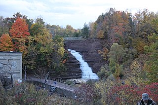
Carlton is a town in Orleans County, New York, United States. The population was 2,994 at the 2010 census. The name is derived from Carleton, a shipbuilding district near Ottawa, Ontario, Canada.
Tweed is a municipality and a village located in central-eastern Ontario, Canada, in Hastings County.

Central Frontenac is a township in eastern Ontario, Canada in the County of Frontenac.

The Municipality of Centre Hastings is a township in Eastern Ontario, Canada, in Hastings County. It was formed on January 1, 1998, through the amalgamation of Huntingdon Township with the Village of Madoc.

Central Ontario is a secondary region of Southern Ontario in the Canadian province of Ontario that lies between Georgian Bay and the eastern end of Lake Ontario.

The Trent River is a river in southeastern Ontario which flows from Rice Lake to empty into the Bay of Quinte on Lake Ontario. This river is part of the Trent-Severn Waterway which leads to Georgian Bay. The river is 90 kilometres (56 mi) long. The Trent drains a large portion of south-central Ontario, including most of the Kawartha Lakes and their supplying watersheds.
Loyalist College is an English-language college in Belleville, Ontario, Canada.
Limerick is a small township in Hastings County, Ontario, Canada, near Limerick Lake. It is located 80 kilometres (50 mi) north of Belleville between Madoc and Bancroft and served by Ontario Highway 62 and County Road 620. The Township is bordered by the Town of Bancroft, Township of Wollaston and the joined Townships of Tudor and Cashel. The township is heavily forested, as is the shoreline of the Limerick Lake, the main industry in the township being forestry and logging. The population of Limerick Township is approx. 300 full-year residents, and another 1000 seasonal residents.

The Township of Alnwick/Haldimand is a township in central Ontario, Canada, in Northumberland County, situated between Lake Ontario and Rice Lake. It was formed in 2001 by the merger of Alnwick Township in the north and Haldimand Township in the south. Alderville First Nation is an autonomously governed First Nation contained within the township boundaries, in two non-contiguous sections along County Roads 45 and 18.

Mountain View is a small community located in Prince Edward County, Ontario on the north shore of Lake Ontario. Mountain View is the location of a former British Commonwealth Air Training Plan air station which is now known as Canadian Forces Detachment Mountain View, a detachment of CFB Trenton.
Stirling-Rawdon is a township in the Canadian province of Ontario, located in Hastings County. It was formed on January 1, 1998, through the amalgamation of Rawdon Township with the Village of Stirling. Stirling was named the 2012 Kraft Hockeyville winner, after gaining more than 3.9 million votes.
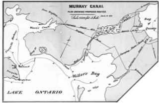
The Murray Canal is a canal in the municipalities of Quinte West and Brighton, Ontario, Canada, and runs from the western end of the Bay of Quinte to Presqu'ile Bay on Lake Ontario. It is approximately 8 kilometres (5 mi) in length and has maximum depth of 9 feet (2.7 m). The canal shortens the trip for boats wishing to access Lake Ontario from the central and western Bay of Quinte by avoiding having to go around the whole peninsula of Prince Edward County.
Tudor and Cashel is a township in the Canadian province of Ontario, located in Hastings County.

Stone Mills is a lower tier township located north of Greater Napanee in Lennox and Addington County, Ontario, Canada. According to the 2011 Canadian Census, the township has a population of 7,560
Ameliasburgh is a village in the Township of Ameliasburgh in Prince Edward County, Ontario, Canada. The village of Ameliasburgh was sometimes known as "Roblin's Mills" after one of its early settlers and the mill he built; the shallow lake to the south of the village is known as Roblin Lake. One of the first townships surveyed in Ontario, Ameliasburgh Township, bordered on the north by the south shore of the Bay of Quinte, was known as "Seventh Town" in the early days of settlement. Much later, the poet Al Purdy lived in a cottage on Roblin Lake for many years. Several of Purdy's poems, most famously including "Wilderness Gothic", mention features in and around Ameliasburgh. The church whose spire "Wilderness Gothic" has being "sheathed in new metal" is now part of the Ameliasburgh Museum. The Ameliasburgh library, which has a collection of Purdy memorabilia on display, is named after Purdy, as is the road leading from the town to the Roblin millpond. The Roblin Mill has been relocated to Black Creek Pioneer Village in Toronto.
Glenora is a community in the Canadian province of Ontario, on the southern shore of the Bay of Quinte at 44°02′N77°03′W. The Bay of Quinte is a long narrow inlet on the northern shore of Lake Ontario.
Diamond Lake is the name of at least nine different lakes in Ontario, Canada:
Mountain Lake (Ontario) may refer to one of a number of lakes in Ontario, Canada with this precise name or to others with similar names.
Bear Lake may refer to one of 29 lakes of that name in Ontario, Canada:
Big Island is an island in Prince Edward County, Ontario, Canada. Approximately 5.8 miles in length and with a maximal width of 2 miles, it is located in the Bay of Quinte in Lake Ontario, between Belleville and Demorestville. It is accessed by a fixed causeway of 0.4 miles in length which connects Big Island to the remainder of Prince Edward County. The island is within the former Township of Sophiasburgh and is the largest of all off-shore islands in Prince Edward County.


