
Lake Michigan is one of the five Great Lakes of North America. It is the second-largest of the Great Lakes by volume and depth after Lake Superior and the third-largest by surface area, after Lake Superior and Lake Huron. To the east, its basin is conjoined with that of Lake Huron through the wide and deep Straits of Mackinac, giving it the same surface elevation as its easterly counterpart; hydrologically, the two bodies are a single lake that is, by area, the largest freshwater lake in the world.
George Wellington "Cap" Streeter was an American who became infamous in Chicago for his real estate schemes and oftentimes bizarre eccentricity. From 1886 to 1921, Streeter, often through forgery and other manipulative means, attempted to lay claim to 186 acres (0.75 km2) of Lake Michigan shoreline from various owners. Failing in his efforts to defraud wealthy landowners, he turned to selling the disputed land to uninformed buyers. A portion of the real estate near downtown Chicago, known as Streeterville, is named for him.

Lincoln Park is a designated community area on the North Side of Chicago, Illinois. It is located west of Lincoln Park.

Indiana Dunes National Park is a national park of the United States located in northwestern Indiana managed by the National Park Service. It was authorized by Congress in 1966 as the Indiana Dunes National Lakeshore and was redesignated as the nation's 61st national park on February 15, 2019. The park runs for about 20 miles (32 km) along the southern shore of Lake Michigan and covers 15,349 acres (6,212 ha). Along the lakefront, the eastern area is roughly the lake shore south to U.S. 12 or U.S. 20 between Michigan City, Indiana, on the east and the Cleveland-Cliffs steel plant on the west. This area's conservation scheme is enhanced by the older Indiana Dunes State Park. To the west of the steel plant lies West Beach and a small extension south of the steel mill continues west along Salt Creek to Indiana 249. The western area is roughly the shoreline south to U.S. 12 between the Burns Ditch west to Broadway in downtown Gary, Indiana. In addition, there are several outlying areas, including Pinhook Bog, in LaPorte County to the east; the Heron Rookery in Porter County, the center of the park; and the Hoosier Prairie State Nature Preserve and the Hobart Prairie Grove, both in Lake County, the western end of the park.

Michigan Avenue is a north-south street in Chicago that runs at 100 east on the Chicago grid. The northern end of the street is at DuSable Lake Shore Drive on the shore of Lake Michigan in the Gold Coast Historic District. The street's southern terminus is at Sibley Boulevard in the southern suburb of Dolton, but like many other Chicago streets, it exists in several disjointed segments.
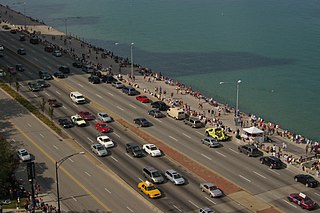
Lake Shore Drive is a semi-limited access expressway that runs alongside the shoreline of Lake Michigan and its adjacent parkland and beaches in Chicago, Illinois. Except for the portion north of Foster Avenue, the Drive is designated part of U.S. Highway 41. A portion of the highway on the Outer Drive Bridge and its bridge approaches is multilevel.

Streeterville is a neighborhood in the Near North Side community area of Chicago, Illinois, United States, north of the Chicago River. It is bounded by the river on the south, the Magnificent Mile portion of Michigan Avenue on the west, and Lake Michigan on the north and east, according to most sources, although the city of Chicago recognizes only a small portion of this region as Streeterville. Thus, it can be described as the Magnificent Mile plus all land east of it. The tourist attraction of Navy Pier and Ohio Street Beach extend out into the lake from southern Streeterville. To the north, the East Lake Shore Drive District, where the Drive curves around the shoreline, may be considered an extension of the Gold Coast. The majority of the land in this neighborhood is reclaimed sandbar.
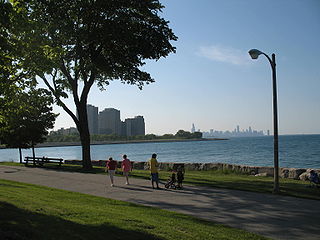
Lincoln Park is a 1,208-acre (489-hectare) park along Lake Michigan on the North Side of Chicago, Illinois. Named after US President Abraham Lincoln, it is the city's largest public park and stretches for seven miles (11 km) from Grand Avenue, on the south, to near Ardmore Avenue on the north, just north of the DuSable Lake Shore Drive terminus at Hollywood Avenue. Two museums and a zoo are located in the oldest part of the park between North Avenue and Diversey Parkway in the eponymous neighborhood. Further to the north, the park is characterized by parkland, beaches, recreational areas, nature reserves, and harbors. To the south, there is a more narrow strip of beaches east of Lake Shore Drive, almost to downtown. With 20 million visitors per year, Lincoln Park is the second-most-visited city park in the United States, behind Manhattan's Central Park.

The Near North Side is the eighth of Chicago's 77 community areas. It is the northernmost of the three areas that constitute central Chicago, the others being the Loop and the Near South Side. The community area is located north and east of the Chicago River. To its east is Lake Michigan, and its northern boundary is the early 19th-century city limit of Chicago, North Avenue. In 2020 the Near North Side had 105,481 residents, surpassing Lake View as the largest Chicago community area by population. It is also the most densely populated community area and has the second most skyscrapers, after the Loop. With the exception of areas near Goose Island in the northwest, the Near North Side is known for its affluence, typified by the Gold Coast, Magnificent Mile, Navy Pier, and residential skyscrapers.

Toronto Harbour or Toronto Bay is a natural bay on the north shore of Lake Ontario, in Toronto, Ontario, Canada. Today, the harbour is used primarily for recreational boating, including personal vessels and pleasure boats providing scenic or party cruises. Ferries travel from docks on the mainland to the Islands, and cargo ships deliver aggregates and raw sugar to industries located in the harbour. Historically, the harbour has been used for military vessels, passenger traffic and cargo traffic. Waterfront uses include residential, recreational, cultural, commercial and industrial sites.

Millennium Station is a major commuter rail terminal in the Loop (downtown), Chicago. It is the northern terminus of the Metra Electric District to Chicago's southern suburbs, and the western terminus of the South Shore Line to Gary and South Bend, Indiana.

Lake Chicago was a prehistoric proglacial lake that is the ancestor of what is now known as Lake Michigan, one of North America's five Great Lakes. Formed about 13,000 years ago and fed by retreating glaciers, it drained southwest through the Chicago Outlet River.

Grand Haven State Park is a public recreation area on the shores Lake Michigan on the south side of the mouth of the Grand River and harbor in Grand Haven, Michigan. The state park encompasses 48 acres (19 ha) consisting entirely of beach sand. It features camping and beach activities along with scenic views of the Grand Haven South Pierhead Entrance Light and Grand Haven South Pierhead Inner Light.
Burnham Park is a public park located in Chicago, Illinois. Situated along 6 miles (9.7 km) of Lake Michigan shoreline, the park connects Grant Park at 14th Street to Jackson Park at 56th Street. The 598 acres (242 ha) of parkland is owned and managed by the Chicago Park District. It was named for urban planner and architect Daniel Burnham in 1927. Burnham was one of the designers of the 1893 World's Columbian Exposition.

The East Lake Shore Drive District is a historic district in the Near North Side community area of Chicago, Illinois. It includes eight buildings at 140 E. Walton, 179-229 E. Lake Shore Drive, and 999 N. Lake Shore Drive designed by Marshall and Fox and Fugard & Knapp and the opposing park. It was designated a Chicago Landmark district on April 18, 1985. These buildings include seven luxury high rise apartment buildings and the Drake Hotel. Note that neither of the buildings on either end of the district actually has an East Lake Shore Drive address. This district is located within the Streeterville neighborhood and overlaps with the Gold Coast.

Tourism in Chicago draws on the city's architecture, museums, restaurants, sports, parks and beaches, theater and wide variety of neighborhood attractions.

The Gold Coast Historic District is a historic district in Chicago, Illinois. Part of Chicago's Near North Side community area, it is roughly bounded by North Avenue, Lake Shore Drive, Oak Street, and Clark Street.

The Chicago Lakefront Trail (LFT) is a 18.5-mile-long (29.8 km) partial shared-use path for walking, jogging, skateboarding, and cycling, located along the western shore of Lake Michigan in Chicago, Illinois. The trail passes through and connects Chicago's four major lakefront parks along with various beaches and recreational amenities. It also serves as a route for bicycle, skateboard and personal transporter commuters. On busy summer days 70,000 people use the trail.

Oak Lake is a lake in the southwestern region of the Canadian province of Manitoba.


