
Victoria Island is a large island in the Canadian Arctic Archipelago that straddles the boundary between Nunavut and the Northwest Territories of Canada. It is the eighth largest island in the world, and at 217,291 km2 (83,897 sq mi) in area, it is Canada's second largest island. It is nearly double the size of Newfoundland (111,390 km2 [43,008 sq mi]), and is slightly larger than the island of Great Britain (209,331 km2 [80,823 sq mi]) but smaller than Honshu (225,800 km2 [87,182 sq mi]). It contains the world's largest island within an island within an island. The western third of the island belongs to the Inuvik Region in the Northwest Territories; the remainder is part of Nunavut's Kitikmeot Region.

The Federal Deposit Insurance Corporation (FDIC) is a United States government corporation providing deposit insurance to depositors in U.S. commercial banks and savings institutions. The FDIC was created by the 1933 Banking Act, enacted during the Great Depression to restore trust in the American banking system. More than one-third of banks failed in the years before the FDIC's creation, and bank runs were common. The insurance limit was initially US$2,500 per ownership category, and this was increased several times over the years. Since the passage of the Dodd–Frank Wall Street Reform and Consumer Protection Act in 2011, the FDIC insures deposits in member banks up to US$250,000 per ownership category.

Victoria Land is a region of Antarctica which fronts the western side of the Ross Sea and the Ross Ice Shelf, extending southward from about 70°30'S to 78°00'S, and westward from the Ross Sea to the edge of the Antarctic Plateau. It was discovered by Captain James Clark Ross in January 1841 and named after the UK's Queen Victoria. The rocky promontory of Minna Bluff is often regarded as the southernmost point of Victoria Land, and separates the Scott Coast to the north from the Hillary Coast of the Ross Dependency to the south.

The Greenwell Glacier is a major tributary glacier, 45 nautical miles long, draining northwest between the Mirabito Range and the Everett Range to enter Lillie Glacier below Mount Works, in northwest Victoria Land, Antarctica. This geographical feature was first mapped by the United States Geological Survey from surveys and from U.S. Navy aerial photography, 1960–63, and was so named by the Advisory Committee on Antarctic Names for Commander Martin D. Greenwell, U.S. Navy, Commander of Antarctic Squadron Six (VX-6), 1961–62. The glacier lies situated on the Pennell Coast, a portion of Antarctica lying between Cape Williams and Cape Adare.

The Welcome Stranger is the biggest alluvial gold nugget found, which had a calculated refined weight of 97.14 kilograms (3,123 ozt). It measured 61 by 31 cm and was discovered by prospectors John Deason and Richard Oates on 5 February 1869 at Moliagul, Victoria, Australia, about 14.6 kilometres north-west of Dunolly.

Mermaid Beach is a suburb on the Gold Coast in Queensland, Australia. At the 2011 Census, Mermaid Beach had a population of 5,722.
Astapenko Glacier is a glacier, 11 miles (18 km) long, draining the north and northeast slopes of Stanwix Peak in the Bowers Mountains and flowing east-northeast to Ob' Bay, situated in Victoria Land, Antarctica. It was mapped by the United States Geological Survey from surveys and from U.S. Navy air photos, 1960–62, and named by the Advisory Committee on Antarctic Names for Pavel D. Astapenko, Soviet IGY observer, a Weather Central meteorologist at Little America V in 1958. The glacier lies on the Pennell Coast, a portion of Antarctica lying between Cape Williams and Cape Adare.
Borchgrevink Canyon is an undersea canyon on the continental rise east of Iselin Bank in the Ross Sea. It was named in association with Borchgrevink Coast, the name being approved by the Advisory Committee for Undersea Features in June 1988.
Upper Staircase is the upper eastern portion of Skelton Glacier, just north of The Landing, which merges into the Skelton Neve in the Hillary Coast region of the Ross Dependency. Surveyed in 1957 by the New Zealand party of the Commonwealth Trans-Antarctic Expedition (1956–58) and so named because of its staircase effect in being the key for the approach to the polar plateau.
Oates Canyon is an undersea canyon on the continental rise east of Iselin Bank in Antarctica. Its name is associated with Oates Coast.
Nielsen Fjord is a fjord 2 nautical miles (3.7 km) wide between Cape North and Gregory Bluffs on the north coast of Victoria Land. Named by ANARE for Captain Hans Nielsen, master of the MV Thala Dan used in exploring this coast, 1962.
Warren Ice Piedmont is an ice piedmont on the Rymill Coast of Palmer Land, lying westward of Traverse Mountains and bounded north and south by Terminus Nunatak and Riley Glacier, the latter once considered to include this ice piedmont. The feature was photographed from the air by the U.S. Navy, 1966, and surveyed by British Antarctic Survey (BAS), 1970-73. Named by the United Kingdom Antarctic Place-Names Committee (UK-APC) in 1978 after Douglas E. Warren, Director of Overseas Surveys, 1968–80, with overall responsibility for British mapping in the Antarctic.
The Gregory Bluffs are high granite bluffs that form the east side of Nielsen Fjord on the north coast of Victoria Land, Antarctica. These geographical features were so named by the Australian National Antarctic Research Expeditions (ANARE) for C. Gregory, a former geologist with the ANARE cruise. On February 12, 1962, pilot John Stanwix, accompanied with Gregory and their party leader Phillip Law, landed a helicopter at the foot of these bluffs to examine them. These bluffs lies situated on the Pennell Coast, a portion of Antarctica lying between Cape Williams and Cape Adare.

Pennell Coast is that portion of the coast of Antarctica between Cape Williams and Cape Adare. To the west of Cape Williams lies Oates Coast, and to the east and south of Cape Adare lies Borchgrevink Coast. Named by New Zealand Antarctic Place-Names Committee (NZ-APC) in 1961 after Lieutenant Harry Pennell, Royal Navy, commander of the Terra Nova, the expedition ship of the British Antarctic Expedition, 1910-13. Pennell engaged in oceanographic work in the Ross Sea during this period. In February 1911 he sailed along this coast in exploration and an endeavor to land the Northern Party led by Lieutenant Victor Campbell.
Robb Glacier is a glacier about 40 nautical miles (70 km) long, flowing from Clarkson Peak north along the east side of Softbed Ridges to the Ross Ice Shelf at Cape Goldie. Named by the expedition after Murray Robb, leader of the New Zealand Geological Survey Antarctic Expedition (NZGSAE) (1959–60), who traversed this glacier to reach Lowery Glacier.
Laizure Glacier is a broad glacier that enters the sea immediately west of Drake Head, Oates Coast, Antarctica. The glacier was roughly plotted by Australia from U.S. Navy Operation Highjump photography, 1946–47, and from photographs and other data obtained by Australian National Antarctic Research Expeditions, 1959–62. It was mapped in detail by the United States Geological Survey from surveys and U.S. Navy photography, 1960–64, and was named by the Advisory Committee on Antarctic Names for Lieutenant David H. Laizure, U.S. Navy, a navigator on LC-130 aircraft during Operation Deep Freeze 1968.

Somov Sea was a proposed name for part of the Southern Ocean. It would be located north of the easternmost part of the Antarctic subcontinent East Antarctica, north of Oates Coast, Victoria Land, and of George V Coast, between 150° and 170° East. West of it would be the D'Urville Sea. East of Cape Adare, at 170°14' East, is the Ross Sea.
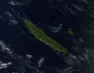
Grande Terre is the largest and principal island of New Caledonia.

