Iwiny is a village in the administrative district of Gmina Siechnice, within Wrocław County, Lower Silesian Voivodeship, in south-western Poland. Prior to 1945 it was in Germany.
Budziska is a village in the administrative district of Gmina Skrwilno, within Rypin County, Kuyavian-Pomeranian Voivodeship, in north-central Poland.
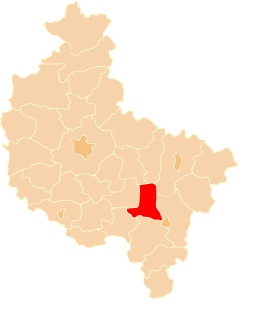
Łojewka is a settlement in the administrative district of Gmina Dąbrowice, within Kutno County, Łódź Voivodeship, in central Poland.
Józefów nad Wisłą is a small town in Opole Lubelskie County, Lublin Voivodeship, in eastern Poland. It is the seat of the gmina called Gmina Józefów nad Wisłą. It lies approximately 16 kilometres (10 mi) south-west of Opole Lubelskie and 57 km (35 mi) south-west of the regional capital Lublin.
Las is a village in the administrative district of Gmina Nielisz, within Zamość County, Lublin Voivodeship, in eastern Poland. It lies approximately 17 kilometres (11 mi) west of Zamość and 62 km (39 mi) south-east of the regional capital Lublin.
Lewoszów is a village in the administrative district of Gmina Radoszyce, within Końskie County, Świętokrzyskie Voivodeship, in south-central Poland. It lies approximately 4 kilometres (2 mi) south of Radoszyce, 22 km (14 mi) south-west of Końskie, and 32 km (20 mi) north-west of the regional capital Kielce.
Rogienice is a village in the administrative district of Gmina Włoszczowa, within Włoszczowa County, Świętokrzyskie Voivodeship, in south-central Poland. It lies approximately 11 kilometres (7 mi) south-east of Włoszczowa and 43 km (27 mi) west of the regional capital Kielce.
Miny is a village in the administrative district of Gmina Secemin, within Włoszczowa County, Świętokrzyskie Voivodeship, in south-central Poland. It lies approximately 7 kilometres (4 mi) north-east of Secemin, 8 km (5 mi) south-west of Włoszczowa, and 52 km (32 mi) west of the regional capital Kielce.
Żelisławiczki is a village in the administrative district of Gmina Secemin, within Włoszczowa County, Świętokrzyskie Voivodeship, in south-central Poland. It lies approximately 6 kilometres (4 mi) north-east of Secemin, 9 km (6 mi) south-west of Włoszczowa, and 53 km (33 mi) west of the regional capital Kielce.
Janki is a village in the administrative district of Gmina Błędów, within Grójec County, Masovian Voivodeship, in east-central Poland.
Sewerynów is a village in the administrative district of Gmina Huszlew, within Łosice County, Masovian Voivodeship, in east-central Poland.
Tymianek is a village in the administrative district of Gmina Koźminek, within Kalisz County, Greater Poland Voivodeship, in west-central Poland. It lies approximately 19 kilometres (12 mi) east of Kalisz and 118 km (73 mi) south-east of the regional capital Poznań.
Topólka is a settlement in the administrative district of Gmina Miejska Górka, within Rawicz County, Greater Poland Voivodeship, in west-central Poland. It lies approximately 6 kilometres (4 mi) north-east of Miejska Górka, 15 km (9 mi) north-east of Rawicz, and 81 km (50 mi) south of the regional capital Poznań.
Grzybków is a village in the administrative district of Gmina Słupca, within Słupca County, Greater Poland Voivodeship, in west-central Poland. It lies approximately 12 kilometres (7 mi) east of Słupca and 78 km (48 mi) east of the regional capital Poznań.
Mariankowo is a village in the administrative district of Gmina Siedlec, within Wolsztyn County, Greater Poland Voivodeship, in west-central Poland. It lies approximately 13 kilometres (8 mi) north-west of Wolsztyn and 63 km (39 mi) west of the regional capital Poznań.

Gręboszów is a village in the administrative district of Gmina Domaszowice, within Namysłów County, Opole Voivodeship, in south-western Poland. It lies approximately 8 kilometres (5 mi) east of Namysłów and 45 km (28 mi) north of the regional capital Opole.
Myślimierz is a village in the administrative district of Gmina Trzebielino, within Bytów County, Pomeranian Voivodeship, in northern Poland. It lies approximately 10 kilometres (6 mi) north of Trzebielino, 35 km (22 mi) north-west of Bytów, and 104 km (65 mi) west of the regional capital Gdańsk.
Strużka is a settlement in the administrative district of Gmina Chojnice, within Chojnice County, Pomeranian Voivodeship, in northern Poland. It lies approximately 12 kilometres (7 mi) north of Chojnice and 96 km (60 mi) south-west of the regional capital Gdańsk.
Rzepecka is a settlement in the administrative district of Gmina Luzino, within Wejherowo County, Pomeranian Voivodeship, in northern Poland. It lies approximately 7 kilometres (4 mi) south-west of Luzino, 17 km (11 mi) south-west of Wejherowo, and 43 km (27 mi) north-west of the regional capital Gdańsk.
Drwęca is a settlement in the administrative district of Gmina Iława, within Iława County, Warmian-Masurian Voivodeship, in northern Poland.