Related Research Articles

The North Country Trail is a long-distance hiking trail in the Midwestern and Northeastern United States. The trail extends roughly 4,800 miles (7,700 km) from Lake Sakakawea State Park in North Dakota to the Appalachian Trail in Green Mountain National Forest in Vermont, passing through eight states along its route. As of 2023, most of the trail is in place, though about one-third of the distance consists of road walking; those segments are frequently evaluated for transfer to off-road segments on nearby public or private lands.

The East Coast Greenway is a 3,000-mile (4,800 km) pedestrian and bicycle route between Maine and Florida along the East Coast of the United States. The nonprofit East Coast Greenway Alliance was created in 1991 with the goal to use the entire route with off-road, shared-use paths; as of 2021, over 1,000 mi (1,600 km) of the route (35%) meets these criteria. In 2020, the Greenway received over 50 million visits.

The Trans Canada Trail, officially named The Great Trail between September 2016 and June 2021, is a cross-Canada system of greenways, waterways, and roadways that stretches from the Atlantic to the Pacific to the Arctic oceans. The trail extends over 24,000 km (15,000 mi); it is now the longest recreational, multi-use trail network in the world. The idea for the trail began in 1992, shortly after the Canada 125 celebrations. Since then it has been supported by donations from individuals, corporations, foundations, and all levels of government.

Southwick Beach State Park is a New York State park that lies along an unusual stretch of sandy beach on the eastern shore of Lake Ontario. The park is 464 acres (188 ha) in size with a 3,500 foot (1,100 m) length of beach, and is visited annually by about 100,000 people. Immediately to the south is the Lakeview Wildlife Management Area, which extends the publicly accessible beach by several miles. They are in the Town of Ellisburg in Jefferson County, New York south of the lakeside community of Jefferson Park.

The American Discovery Trail is a system of recreational trails and roads that collectively form a coast-to-coast hiking and biking trail across the mid-tier of the United States. Horses can also be ridden on most of this trail. The coastal trailheads are the Delmarva Peninsula on the Atlantic Ocean and the northern California coast on the Pacific Ocean. The trail has northern and southern alternates for part of its distance, passing through Chicago and St. Louis respectively. The total length of the trail, including both the north and south routes, is 6,800 miles (10,900 km). The northern route covers 4,834 miles (7,780 km) with the southern route covering 5,057 miles (8,138 km). It is the only non-motorized coast-to-coast trail.
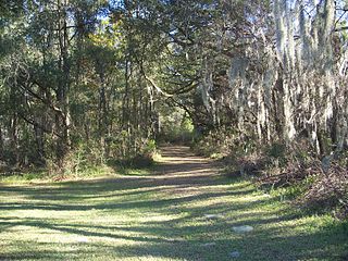
The Marjorie Harris Carr Cross Florida Greenway is a protected green belt corridor, more than one and a half miles (2.4 km) wide in places, that was the former route of the proposed Cross Florida Barge Canal. It is named for the leader of opposition to the Cross Florida Barge Canal, Marjorie Harris Carr, and was originally a U.S. Army Corps of Engineers canal project to connect the Gulf of Mexico and the Atlantic Ocean across Florida for barge traffic. Two sections were built, but the project was ultimately cancelled because of local opposition related to environmental concerns, including protecting the state's water supply and conservation of the Ocklawaha River Valley ecosystem, as well as national opposition for the costs being perceived as "government waste" with "limited national value." The greenway is part of the system of Florida State Parks, including the Santos Trail System, and is managed by the Florida Department of Environmental Protection.

A greenway is usually a shared-use path along a strip of undeveloped land, in an urban or rural area, set aside for recreational use or environmental protection. Greenways are frequently created out of disused railways, canal towpaths, utility company rights of way, or derelict industrial land. Greenways can also be linear parks, and can serve as wildlife corridors. The path's surface may be paved and often serves multiple users: walkers, runners, bicyclists, skaters and hikers. A characteristic of greenways, as defined by the European Greenways Association, is "ease of passage": that is that they have "either low or zero gradient", so that they can be used by all "types of users, including mobility impaired people".

The 74-mile-long (119 km) Ocklawaha River flows north from central Florida until it joins the St. Johns River near Palatka. Its name is derived from ak-lowahe, Creek for "muddy".

The Florida Trail is one of eleven National Scenic Trails in the United States, created by the National Trails System Act of 1968. It runs 1,500 miles (2,400 km), from Big Cypress National Preserve to Fort Pickens at Gulf Islands National Seashore, Pensacola Beach. Also known as the Florida National Scenic Trail, the trail provides permanent non-motorized recreation for hiking and other compatible activities within an hour of most floridians.

The Withlacoochee River or Crooked River is a river in central Florida, in the United States. It originates in the Green Swamp, east of Polk City, flowing west, then north, then northwest and finally west again before emptying into the Gulf of Mexico near Yankeetown. The river is 141 miles (227 km) long and has a drainage basin of 1,170 square miles (3,000 km2).

The Pacific Northwest Trail (PNT) is a 1,200-mile (1,900 km) hiking trail running from the Continental Divide in Montana to the Pacific Ocean on Washington's Olympic Coast. Along the way, the PNT crosses three national parks, seven national forests, and two other national scenic trails. It travels against the grain of several mountain ranges, including the Continental Divide, Whitefish Divide, Purcells, Selkirks, Kettles, Cascades, and Olympics. It was designated as the Pacific Northwest National Scenic Trail by Congress in 2009.

The Bay Circuit Trail and Greenway or Bay Circuit is a Massachusetts rail trail and greenway connecting the outlying suburbs of Boston from Plum Island in Newburyport to Kingston Bay in Duxbury, a distance of 200 miles (320 km).

The Palatka-Lake Butler State Trail (PLB) corridor stretches nearly 47 miles (76 km) from the vicinity of Lake Butler, Florida to Palatka, Florida. The project is located along the former Georgia Southern and Florida Railway right-of-way and the trail is being constructed on top of the existing abandoned railroad bed through Putnam, Clay, Bradford, and Union counties.

The Anacostia Tributary Trail System (ATTS) is a unified and signed system of stream valley trails joining trails along the Anacostia tributaries of Northwest Branch, Northeast Branch, Indian Creek and Paint Branch with a trail along the Anacostia River, set aside and maintained by the Maryland-National Capital Park and Planning Commission (M-NCPPC) in the Maryland suburbs of Washington, D.C.
DuPuis Management Area is a 21,875 acre protected area in northwestern Palm Beach County, Florida and southwestern Martin County, Florida. Recreational opportunities include hunting, horseback riding, cycling, camping, hiking, auto touring, and fishing. During hunting periods it is closed to other use. The property includes a visitor center. Dogs are not allowed on the property. The park includes 22 miles of hiking trails, including a stretch of the Ocean to Lake Trail. There is also an equestrian campground and 40 miles of horseback riding trails. The park is located off State Road 76. It is along the Ocean to Lake Trail.

The Nature Coast State Trail (NCST) is a 31.7-mile long segment of Florida's Statewide System of Greenways and Trails System built along abandoned railroad tracks, and designated by the U.S. Department of the Interior as a National Recreation Trail. It has two primary sections following unused rail lines that were originally built by the Atlantic Coast Line Railroad. It includes historic sites such as a 1902 train trestle bridge over the Suwannee River near Old Town and train stations in Trenton, Cross City, and Chiefland. At Wilcox Junction abandoned rail tracks cross and connect with several communities. The trail is available to hikers, cyclists, and horse riders.
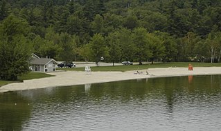
Mount Sunapee State Park is a public recreation area in Newbury, New Hampshire. The state park's nearly 3,000 acres (1,200 ha) include most of Mount Sunapee and a beach area on Lake Sunapee. Park activities include swimming, hiking, camping, skiing, fishing, picnicking, and non-motorized boating. The park's ski area is operated as Mount Sunapee Resort under the management of Vail Resorts Inc.
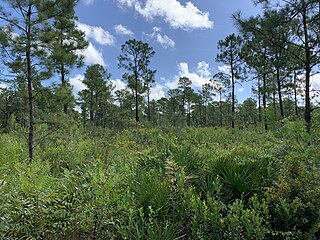
Price’s Scrub State Park is a 962-acre Florida state park located in Marion County, Florida. The park has relatively high biodiversity with several natural communities, including its scrub, and is important in the proposed regional connection of conservation lands. The park is a part of the proposed Northwest Marion Greenway. This corridor would connect Paynes Prairie Preserve State Park to Goethe State Forest and could be used for recreational activities, particularly horseback riding.
References
- ↑ "The Ocean to Lake Hiking Trail" (PDF). Florida Trail Association - Loxahatchee Chapter. Archived from the original (PDF) on May 24, 2024. Retrieved May 24, 2024.
- ↑ Ocean to Lake Northeast Everglades Trails Association
- ↑ Ocean to Lake Trail Florida Trail website
| | This United States trail or long-distance path–related article is a stub. You can help Wikipedia by expanding it. |