
The Northern Territory is an Australian internal territory in the central and central northern regions of Australia. The Northern Territory shares its borders with Western Australia to the west, South Australia to the south, and Queensland to the east. To the north, the territory looks out to the Timor Sea, the Arafura Sea and the Gulf of Carpentaria, including Western New Guinea and other islands of the Indonesian archipelago.
The protected areas of the Northern Territory consists of protected areas managed by the governments of the Northern Territory and Australia and private organisations with a reported total area of 335,527 square kilometres (129,548 sq mi) being 24.8% of the total area of the Northern Territory of Australia.

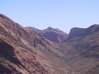
Tjoritja /West MacDonnell is a national park in the Northern Territory (Australia) due west of Alice Springs and 1234 km south of Darwin. It extends along the MacDonnell Ranges west of Alice Springs.
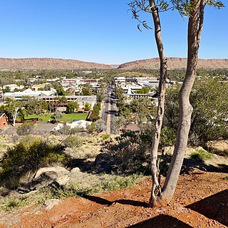
Alice Springs is a town in the Northern Territory, Australia; it is the third-largest settlement after Darwin and Palmerston. The name Alice Springs was given by surveyor William Whitfield Mills after Alice, Lady Todd, wife of the telegraph pioneer Sir Charles Todd. Known colloquially as The Alice or simply Alice, the town is situated roughly in Australia's geographic centre. It is nearly equidistant from Adelaide and Darwin.

Ochre, iron ochre, or ocher in American English, is a natural clay earth pigment, a mixture of ferric oxide and varying amounts of clay and sand. It ranges in colour from yellow to deep orange or brown. It is also the name of the colours produced by this pigment, especially a light brownish-yellow. A variant of ochre containing a large amount of hematite, or dehydrated iron oxide, has a reddish tint known as red ochre.
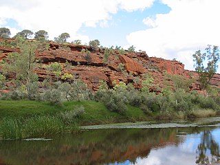
The Finke River, or Larapinta in the Indigenous Arrernte language, is a river in central Australia, whose bed courses through the Northern Territory and the state of South Australia. It is one of the four main rivers of Lake Eyre Basin and is thought to be the oldest riverbed in the world. It flows for only a few days a year. When this happens, its water usually disappears into the sands of the Simpson Desert, rarely if ever reaching Lake Eyre.
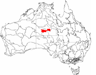
The MacDonnell Ranges, or Tjoritja in Arrernte, is a mountain range located in southern Northern Territory. MacDonnell Ranges is also the name given to an interim Australian bioregion broadly encompassing the mountain range, with an area of 3,929,444 hectares. The range is a 644 km (400 mi) long series of mountains in central Australia, consisting of parallel ridges running to the east and west of Alice Springs. The mountain range contains many spectacular gaps and gorges as well as areas of Aboriginal significance.
The Larapinta Trail is an extended walking track in the Northern Territory of Australia. Its total length covers 223 kilometres (139 mi) from east to west, with the eastern end at Alice Springs and the western end at Mount Sonder, one of the territory's highest mountains. It follows the West MacDonnell Ranges, sometimes along the ridge line, other times on the plain below, in the West MacDonnell National Park.

Ormiston Pound is a ring of mountains in the Northern Territory of Australia punctuating the MacDonnell Ranges, in the West MacDonnell National Park, approximately 135 kilometres (84 mi) west of Alice Springs. It lies at roughly the halfway point in the Larapinta Trail and has views from its circumference of Mount Sonder, Gosses Bluff crater and the surrounding range.
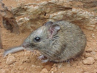
The central rock rat, also known as the central thick-tailed rock-rat, Macdonnell Range rock-rat, and Australian native mouse, is a critically endangered species of rodent in the family Muridae, endemic to Australia.
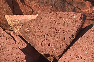
The Napwerte /Ewaninga Rock Carvings Conservation Reserve is a protected area in the Northern Territory of Australia consisting of an area of low sand dunes, rocky outcrops and a claypan about 35 kilometres (22 mi) south of Alice Springs. It is significant because of a large number of Aboriginal rock carvings and it is a sacred men's site of the Arrernte people who are its traditional owners.
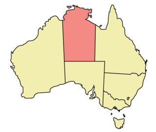
The Northern Territory (NT) occupies the north central part of the continent of Australia. The Northern Territory borders are to the west with Western Australia, the Western Australia border being near the 129° east longitude. The NT to the south with the South Australian border being the 26th parallel south latitude. To the east the NT with the Queensland border along the 138° east longitude.
The Central Ranges xeric scrub is a deserts and xeric shrublands ecoregion of Australia.
Narwietooma Station, most commonly known as Narwietooma, is a pastoral lease that operates as a cattle station in the Northern Territory of Australia. It is on the traditional lands of the Western Arrernte and Anmatyerr people who are the recognised Native Title holders of large sections of land that make up the station.
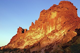
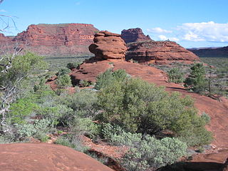
Rainbow Valley Conservation Reserve is a protected area located south of Alice Springs, Northern Territory in Australia. The reserve was established in 1990 to protect the unique sandstone formations and the Aboriginal art, artifacts and sacred natural objects within an area of 24.83 km2 (9.59 sq mi) around a large sandstone bluff. The sandstone layers in the main formation resemble the coloured stripes of a rainbow, with the red-orange hues of sandstone that is rich with iron creating a strong contrast with the lighter shaded sandstone that turns pale yellow or gold in the late day sun as it shines on the northwest-facing cliffs.

Arltunga Historical Reserve, known also as Arnerre-ntyenge is a deserted gold rush town located in the Northern Territory of Australia in the locality of Hart about 110 kilometres (68 mi) east of Alice Springs. It is on the lands of the Eastern Arrernte people who are the traditional owners.
Owen Springs Station, now known as Owen Springs Reserve is a former pastoral station and now a 1,570-square-kilometre (606 sq mi) nature reserve west of Alice Springs in the Northern Territory of Australia. The Hugh River and Waterhouse Range run through the reserve. It also features the first pastoral homestead built in Central Australia.
Emily Gap / Anthwerrke is a natural attraction and significant cultural site to the Arrernte peoplein the East MacDonnell Ranges, eight kilometres to the east of Mparntwe/Alice Springs, in Australia's Northern Territory. Various sections of the Gap include Aboriginal rock art.
The 2022–23 Australian bushfire season was the season of summer bushfires in Australia. The outlook for the season was below average in coastal parts of south-eastern Australia due to high rainfall associated with the continued La Niña climatic pattern. Elevated fire danger was forecast in Central Australia, inland New South Wales, western Tasmania, southern Queensland and Western Australia, particularly toward the end of the season where drier weather and high fuel loads were expected.

The Winnecke Goldfield, sometimes known as Winnecke Depot Goldfield, is a now abandoned goldfield about 70 kilometres north east of Alice Springs and 50 kilometres north west of Arltunga. It is located within the Central Desert Shire Council region. It is on the lands of the Eastern Arrernte people who are the traditional owners and it is within the within the estate known as Inerentye.

