Ogof Dydd Byraf | |
---|---|
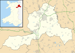
Location | Wrexham County Borough, Wales |
OS grid | SJ 2546 5201 |
Coordinates | 53°03′37″N3°06′49″W / 53.060163°N 3.113618°W Coordinates: 53°03′37″N3°06′49″W / 53.060163°N 3.113618°W |
Length | 750 metres (2,460 ft) |
Elevation | 340 metres (1,120 ft) |
Discovery | 1964 |
Geology | Limestone |
Access | contact North Wales Caving Club |
Translation | cave of the shortest day |
Registry | Cambrian Cave Registry [1] |
Ogof Dydd Byraf is a cave which extends under Esclusham Mountain in north-east Wales from its entrance in the south face of the Minera Limeworks quarry. It was originally discovered and explored in 1964 by the Wrexham Caving Club, before they were merged into the North Wales Caving Club. [2]
After a short series of mined passages there is a narrow 10 metre pitch into the main levels consisting of a series of well-decorated galleries. Some of the passages come very close to the cave Ogof Llyn Du whose access is blocked by a deep and difficult sump.
Over the years this cave had been under threat by the quarry operations, [3] but it is now protected as an SSSI. [4] and owned by North Wales Wildlife Trust [5]
Clwyd is a preserved county of Wales, situated in the north-east corner of the country; it is named after the River Clwyd, which runs through the area. To the north lies the Irish Sea, with the English ceremonial counties of Cheshire to the east and Shropshire to the south-east. Powys and Gwynedd lie to the south and west respectively. Clwyd also shares a maritime boundary with Merseyside along the River Dee. Between 1974 and 1996, a slightly different area had a county council, with local government functions shared with six district councils. In 1996, Clwyd was abolished, and the new principal areas of Conwy County Borough, Denbighshire, Flintshire and Wrexham County Borough were created; under this reorganisation, "Clwyd" became a preserved county, with the name being retained for certain ceremonial functions.
Caldey Island is a small island near Tenby, Pembrokeshire, Wales, less than 1 mile (1.6 km) off the coast. With a recorded history going back over 1,500 years, it is one of the holy islands of Britain. A number of traditions inherited from Celtic times are observed by the Cistercian monks of Caldey Abbey, the owners of the island.
Ogof Craig a Ffynnon is a cave in Wales. The cave is about 7 km in length and is located at the base of a quarried rockface in the Clydach Gorge. Water flowing out of the cave is a resurgence of water draining off Llangatock Mountain above.
Ogof Ffynnon Ddu, also known informally as OFD, is a cave under a hillside in the area surrounding Penwyllt in the Upper Swansea Valley in South Wales. It is the second longest cave in Wales and the deepest in the United Kingdom.
Coedpoeth is a large village and community in Wrexham County Borough, Wales. The built-up area with Minera had a population of 5,723 in the 2011 census.
The Minera Limeworks were extensive lime quarries and kilns at Minera in Wrexham, Wales. It was located at grid reference SJ253520, near the villages of Gwynfryn, Minera, and Coedpoeth and was locally referred to as The Calch.
Ogof Hesp Alyn was discovered by North Wales Caving Club in 1973 in the Alyn Gorge near Cilcain, Flintshire, Wales. Reaching the end of the cave is a serious commitment involving 24 pitches and the draining of two sumps. The proliferation of short, awkward and muddy pitches appear best suited to be tackled by wire ladders, but in the 1980s a team of divers from the Wessex Caving Club who passed the sumps, concluded that single rope technique was preferable, avoiding the need for excessive numbers of people to carry the equipment. A perpetual siphon has since been used at the first sump which does a good job of keeping the water level relatively low, when working properly.
Ogof Hen Ffynhonnau lies in the Alyn Gorge in Flintshire, Wales close to Ogof Hesp Alyn. It was discovered in 1978 after excavation allowed access to Dyer's Adit. Being below a dry river bed, the cave can be prone to flooding in wet weather. There is a short ladder pitch just inside the entrance, and it makes a short trip suitable for novice cavers.
Minera is a small village and community in Wrexham County Borough, Wales. It adjoins the large village of Coedpoeth.
The River Alyn is a tributary of the River Dee. The River Alyn rises at the southern end of the Clwydian hills and the Alyn Valley forms part of the Clwydian Range and Dee Valley Area of Outstanding Natural Beauty. The main town on the river Alyn is Mold, the county town of Flintshire. It lends its name to the constituencies of Alyn and Deeside in the UK Parliament and the Senedd.
Penwyllt is a hamlet located in the upper Swansea Valley in Powys, Wales.
Ogof Agen Allwedd or Agen Allwedd, is, at 32.5 kilometres (20.2 mi), one of the longest cave systems in Wales, and the longest cave system on the Llangattock escarpment.
Trefil is a small village in the county borough of Blaenau Gwent, south Wales. It lies at the top of the Sirhowy Valley, near to Brecon Beacons National Park. It is three miles northwest of Tredegar. With one public house, The Top House, serving homemade food and drinks to local visitors.
The Mold Railway was a railway company that built a line in north-east Wales. The line linked Mold to Chester and it opened on 14 August 1849. The company built a mineral branch line to Ffrith, opened in November 1849. Mold itself was an important regional centre, and contained considerable mineral resources.
Esclusham Mountain is an area in Wrexham County Borough, Wales, United Kingdom, and is part of the Ruabon Moors. It rises to a height of 460 m, with the nearby spur of Cyrn-y-Brain, to the west, reaching 473 m. It lies mostly within the community of Esclusham. A smaller spur to the north, known as Minera Mountain, is within the neighbouring community of Minera.
Gwynfryn is a small mountain village in the community of Minera in Wrexham county borough, Wales. Its name, originally that of the village chapel, is formed from the Welsh words bryn, "hill", and gwyn, "white": "white hill". At the time of the 2001 census, its population combined with that of the neighbouring, larger village of Bwlchgwyn was 1,148.
The Nant Glais Caves are a collection of six caves located near Vaynor in Merthyr Tydfil County Borough, South Wales. The largest cave, Ogof Rhyd Sych, measures around 2000m long. The site has been designated a Site of Special Scientific Interest.
Ogof Llyn Parc usually known as Pool Park is a cave on Esclusham Mountain above Wrexham, Wales, that has a 100 metres (330 ft) entrance shaft, normally descended by winch to the mine levels. Further caving and two ladders reaches the natural cave levels in which there are streamways.
Chartist Cave is a culturally significant cave on Mynydd Llangynidr in southern Powys, Wales. The entrance is a broad arch formed of Twrch Sandstone which overlies the Carboniferous Limestone immediately beneath.
The Clwydian Range and Dee Valley is a designated Area of Outstanding Natural Beauty (AONB) and proposed national park, located in north-east Wales, covering the Clwydian Range, and the valley of the River Dee. Designated in 1985 as the Clwydian Range AONB, and expanded to its current form in 2011, the Area of Outstanding Natural Beauty includes: medieval field systems, open heather moorland, prehistoric hillforts, limestone crags, broad leaved woodland, wooded valleys, and farmland. In 2018, an estimated 1.1 million people visited six key sites across the AONB, generating approximately £24.1 million to the Welsh economy, according to Natural Resources Wales. The AONB falls within the jurisdiction of the local authorities of Denbighshire, Flintshire, and Wrexham County Borough, with the majority, 80% of the AONB in Denbighshire, and the remaining 20% split evenly between the other two authorities. The AONB is the largest of only five AONBs in Wales, and one of the 46 in the United Kingdom. Additionally, it is one of only 8 protected areas of Wales. Long-distance footpaths; Offa's Dyke Path, and the Clwydian Way pass through the AONB. The area of the Clwydian Range and Dee Valley AONB is 390 km2 (150 sq mi), and has been proposed by the Welsh Government to become Wales' fourth national park.
{{cite book}}
: CS1 maint: multiple names: authors list (link)