The Ogon River is a river located in Sanduan Province, Papua New Guinea. [1] [2] It is at an elevation of 2,707 meters above sea level. [3]
The Ogon River is a river located in Sanduan Province, Papua New Guinea. [1] [2] It is at an elevation of 2,707 meters above sea level. [3]

The Arafura Sea lies west of the Pacific Ocean, overlying the continental shelf between Australia and Western New Guinea, which is the Indonesian part of the Island of New Guinea.

Borchgrevink Glacier is a large glacier in the Victory Mountains, Victoria Land, draining south between Malta Plateau and Daniell Peninsula, and thence projecting into Glacier Strait, Ross Sea, as a floating glacier tongue, the Borchgrevink Glacier Tongue, just south of Cape Jones. It was named by the New Zealand Geological Survey Antarctic Expedition, 1957–58, for Carsten Borchgrevink, leader of the British Antarctic Expedition, 1898–1900. Borchgrevink visited the area in February 1900 and first observed the seaward portion of the glacier.

The Yam languages, also known as the Morehead River languages, are a family of Papuan languages. They include many of the languages south and west of the Fly River in Papua New Guinea and Indonesian West Papua.
The Van Daalen River is a river of Western New Guinea in the province of Papua, Indonesia. It is a tributary of Tariku River.

The Tuross River, an open semi-mature wave dominated barrier estuary or perennial stream, is located in the South Coast region of New South Wales, Australia.
The Piva River is a river on the south western coast of Bougainville.
The Bian River or Mbian River is a river of western part of Papua, in the province of Papua, Indonesia. Its total length is 580.6 km and width around 70 – 1447.1 m. Some 900 people in its upper course are said to speak the language Bian Marind.

Rexford Glacier is a glacier flowing northeast into the head of Wagoner Inlet on the north side of Thurston Island. Named by Advisory Committee on Antarctic Names (US-ACAN) after Aviation Radioman Phillip W. Rexford, PBM Mariner aircrewman in the Eastern Group of U.S. Navy Operation Highjump, which obtained aerial photographs of this glacier and adjoining coastal areas, 1946–47.
The Lukuledi is a river in The United Republic Of Tanzania, south-eastern region of Africa. With a total length of 160 km, it rises from the boundary between the Lindi and Mtwara regions.
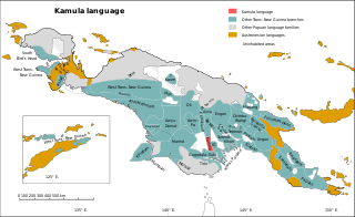
Kamula is a Trans–New Guinea language that is unclassified within that family in the classification of Malcolm Ross (2005). Noting insufficient evidence, Pawley and Hammarström (2018) leave it as unclassified.

Tabo, also known as Waia (Waya), is a Papuan language of Western Province, Papua New Guinea, just north of the Fly River delta. The language has also been known as Hiwi and Hibaradai.
The Balima is a river of New Britain, Papua New Guinea. It enters the sea about five miles from Cape Koas. One of its tributaries is the Bumba Stream.
The Lossuk is a river of north-western New Ireland, Papua New Guinea. The sedimentation and mineral deposits of the river was studied in the mid 1980s.
The Vanapa is a river of Papua New Guinea. It flows into Galley Reach of Redscar Bay to the north-west of Port Moresby.
The Aroa is a river of Papua New Guinea. It flows into the sea in the northern end of Redscar Bay, about 11 miles from Cape Suckling, to the north-west of Port Moresby. 1.75 metres to the south are the Kekeni Rocks, reaching a height of 21 metres (69 ft)
The Frieda River is a river in northern Papua New Guinea.
Segero Creek is a creek located in Western Province, Papua New Guinea.
Ambolotarakely is a municipality in Analamanga Region, in the Central Highlands of Madagascar, located in the North from the capital of Antananarivo. Ambolotarakely is situated in Ankazobe, Antananarivo, Madagascar, its geographical coordinates are 18° 16' 0" South, 47° 24' 0" East.
Akiapmin is a small town in Sandaun Province, Papua New Guinea. Its climate is Rainforest Climate. It’s located near the Ogon River, and the Big Limestone River.
| | This Sandaun Province geography article is a stub. You can help Wikipedia by expanding it. |