
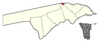
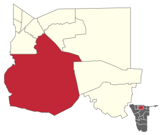
Omusati is one of the fourteen regions of Namibia, its capital is Outapi. The towns of Okahao, Oshikuku and Ruacana as well as the self-governed village Tsandi are situated in this region. As of 2020, Omusati had 148,834 registered voters.
Katima Mulilo UrbanConstituency is an electoral district in Namibia. It is situated in the Zambezi Region. The region's capital, Katima Mulilo, is in this constituency. The constituency has a population of 28,362 people. In the 2020 Regional Council Elections, there were 13,860 registered voters.

Arandis is a constituency in the Erongo Region of central-eastern Namibia. It had a population of 10,093 in 2011, an increase from 7,590 in 2001. As of 2020, the constituency had 8,888 registered voters.
Epupa Constituency is a constituency in the Kunene Region of Namibia. The constituency contains the Epupa Falls after which it is named, located on the Angolan-Namibian border. Its population in 2004 was 12,816. In 2020 it had 12,182 registered voters.

Sesfontein Constituency is an electoral constituency in the Kunene Region of Namibia. Its district capital is the settlement of Sesfontein. The constituency had a population of 7,358 in 2004. As of 2020, it has 5,614 registered voters.

Ongenga is a constituency in the Ohangwena Region of Namibia, on the border to Angola. It had 21,474 in 2004 and 12,682 registered voters in 2020.

Anamulenge Constituency is an electoral constituency in the Omusati Region of northern Namibia. It had 12,470 inhabitants in 2004 and 11,186 registered voters in 2020. Its district capital is the settlement of Anamulenge.

Elim Constituency is an electoral constituency in the Omusati Region of Namibia. It had 15,210 inhabitants in 2004 and 7,883 registered voters in 2020. Its district capital is the settlement of Elim.

Etayi Constituency is an electoral constituency in the Omusati Region of Namibia. It had 34,970 inhabitants in 2004 and 16,716 registered voters in 2020. Its district capital is the settlement of Etayi. The constituency contains the settlements of Iipandayamiti, Oneheke, Onheleiwa, Otindi, Ekangolinene, Oshivanda, Onamhindi, Omutundungu, Olupandu, Onampira, Otshikuyu, Okaleke, Oshipya, and Oikokola.

Okahao Constituency is an electoral constituency in the Omusati Region of Namibia. It had 26,035 inhabitants in 2004 and 12,390 registered voters in 2020. Its district capital is the town of Okahao the birth place of Namibia's Founding Father Sam Nujoma. Okahao Constituency was created in 1998 from existing constituencies of Omusati, following a recommendation of the Second Delimitation Commission of Namibia, and in preparation of the 1998 general election.

Okalongo Constituency is an electoral constituency in the Omusati Region of Namibia on the border to Angola. It has a population of 30,500 and an average household size of 6.30 people. As of 2020, Okalongo had 16,031 registered voters. The constituency's capital is the settlement of Okalongo. Other villages within the constituency include Onandjaba, Omatwadiva, Onaidjimba, Okafitu Kauvale, Olwiili, Ongolo, Ondudu, Onembaba, Ondobe Yehumba, Ondobe Yefidi, Ohakapeke, Olupandu, Epoko, Olupito, Oupale, Oshuundje, Okathitu Konghai, Oikango, Onalumbololo, Uushwa, Orange ya Nashimbuli, Omutundungu, Oshiteyatemo, Aanongo, Ombwana, Eshwa la Hamukwaya and Onambome.

Onesi Constituency is an electoral constituency in the Omusati Region of Namibia on the border to Angola. It had 12,935 inhabitants in 2004 and 9,941 registered voters in 2020. Its district capital is the settlement of Onesi.
Oshikuku Constituency is an electoral constituency in the Omusati Region of Namibia. It had 8,089 inhabitants in 2004 and 9,701 registered voters in 2020. Its district capital is the village of Oshikuku.

Otamanzi Constituency is an electoral constituency in the Omusati Region of Namibia. It had 13,495 inhabitants in 2004 and 7,427 registered voters in 2020. Its district capital is the settlement of Otamanzi, it further contains the settlements of Onandjo, Kelimwe, Etilyasa, Onanyala, Onkani, Iiyekeya, Epato, Amarika, Etsikilo, and Onkaankaa, Okeendapa

Outapi Constituency is an electoral constituency in the Omusati Region of Namibia on the border of Angola. It had 30,313 inhabitants in 2004 and 23,516 registered voters in 2020. Its district capital is the town of Outapi.

Ruacana Constituency is an electoral constituency in the Omusati Region of Namibia on the border to Angola. It had 10,722 inhabitants in 2004 and 9,285 registered voters in 2020. Its district capital is the town of Ruacana.
Tsandi Constituency is an electoral constituency in the Omusati Region of Namibia. It had 26,834 inhabitants in 2004 and 15,618 registered voters in 2020. Its district capital is the settlement of Tsandi.

Okatana Constituency is an electoral constituency in the Oshana Region of Namibia. It had 15,562 inhabitants in 2004 and 9,111 registered voters in 2020. Its district capital is the settlement of Okatana.

Oshakati West is an electoral constituency in the Oshana Region of Namibia. It contains the western parts of the town of Oshakati. The constituency had 20,015 inhabitants in 2004 and 15,120 registered voters in 2020.
Omuthiyagwiipundi Constituency is an electoral constituency in the Oshikoto Region of Namibia. It had 21,884 inhabitants in 2004 and 15,220 registered voters in 2020. The constituency contains the settlements of Omuthiya and Iipundi. The area is predominantly rural.
