
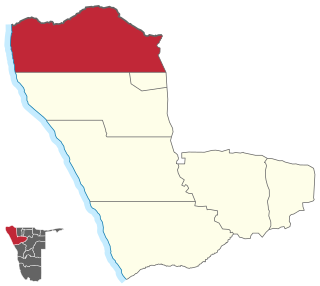
Omusati is one of the fourteen regions of Namibia, its capital is Outapi. The towns of Okahao, Oshikuku and Ruacana as well as the self-governed village Tsandi are situated in this region. As of 2020, Omusati had 148,834 registered voters.

Kunene is one of the fourteen regions of Namibia. Its capital is Opuwo, its governor is Marius Sheya. The region's name comes from the Kunene River which forms the northern border with Angola. Besides the capital Opuwo, the region contains the municipality of Outjo, the town Khorixas and the self-governed village Kamanjab. Kunene is home to the Himba people, a subtribe of the Herero, as well as to Damara people and Nama people. As of 2020, Kunene had 58,548 registered voters.
Epupa Constituency is a constituency in the Kunene Region of Namibia. The constituency contains the Epupa Falls after which it is named, located on the Angolan-Namibian border. Its population in 2004 was 12,816. In 2020 it had 12,182 registered voters.

Outjo is an electoral constituency in the Kunene Region of Namibia. Its district capital is the town of Outjo, its population was 8,947 in 2004. As of 2020, it has 9,197 registered voters.

Kamanjab is a constituency in the Kunene Region of Namibia. In 2004, the population was 6,012. As of 2020, it had 4,862 registered voters. The district capital is the settlement of Kamanjab.

Ruacana is a town in the Omusati Region of northern Namibia and the district capital of the Ruacana electoral constituency. It is located on the border with Angola on the river Kunene. The town is known for the picturesque Ruacana Falls nearby, and for the Ruacana Power Station.

Sesfontein Constituency is an electoral constituency in the Kunene Region of Namibia. Its district capital is the settlement of Sesfontein. The constituency had a population of 7,358 in 2004. As of 2020, it has 5,614 registered voters.

Anamulenge Constituency is an electoral constituency in the Omusati Region of northern Namibia. It had 12,470 inhabitants in 2004 and 11,186 registered voters in 2020. Its district capital is the settlement of Anamulenge.

Elim Constituency is an electoral constituency in the Omusati Region of Namibia. It had 15,210 inhabitants in 2004 and 7,883 registered voters in 2020. Its district capital is the settlement of Elim.

Etayi Constituency is an electoral constituency in the Omusati Region of Namibia. It had 34,970 inhabitants in 2004 and 16,716 registered voters in 2020. Its district capital is the settlement of Etayi. The constituency contains the settlements of Iipandayamiti, Oneheke, Onheleiwa, Otindi, Ekangolinene, Oshivanda, Onamhindi, Omutundungu, Olupandu, Onampira, Otshikuyu, Okaleke, Oshipya, and Oikokola.

Ogongo Constituency is an electoral constituency in the Omusati Region northern part of Namibia. It had 18,498 inhabitants in 2004 and 9,140 registered voters in 2020. Its district capital is the settlement of Ogongo. The constituency further contains the settlements of Eengolo, Eendombe, Pyamukuyu, Iipanda, Ombathi, and Omuthitu.

Okahao Constituency is an electoral constituency in the Omusati Region of Namibia. It had 26,035 inhabitants in 2004 and 12,390 registered voters in 2020. Its district capital is the town of Okahao the birth place of Namibia's Founding Father Sam Nujoma. Okahao Constituency was created in 1998 from existing constituencies of Omusati, following a recommendation of the Second Delimitation Commission of Namibia, and in preparation of the 1998 general election.

Okalongo Constituency is an electoral constituency in the Omusati Region of Namibia on the border to Angola. It has a population of 30,500 and an average household size of 6.30 people. As of 2020, Okalongo had 16,031 registered voters. The constituency's capital is the settlement of Okalongo. Other villages within the constituency include Onandjaba, Omatwadiva, Onaidjimba, Okafitu Kauvale, Olwiili, Ongolo, Ondudu, Onembaba, Ondobe Yehumba, Ondobe Yefidi, Ohakapeke, Olupandu, Epoko, Olupito, Oupale, Oshuundje, Okathitu Konghai, Oikango, Onalumbololo, Uushwa, Orange ya Nashimbuli, Omutundungu, Oshiteyatemo, Aanongo, Ombwana, Eshwa la Hamukwaya and Onambome.

Onesi Constituency is an electoral constituency in the Omusati Region of Namibia on the border to Angola. It had 12,935 inhabitants in 2004 and 9,941 registered voters in 2020. Its district capital is the settlement of Onesi.
Oshikuku Constituency is an electoral constituency in the Omusati Region of Namibia. It had 8,089 inhabitants in 2004 and 9,701 registered voters in 2020. Its district capital is the village of Oshikuku.

Otamanzi Constituency is an electoral constituency in the Omusati Region of Namibia. It had 13,495 inhabitants in 2004 and 7,427 registered voters in 2020. Its district capital is the settlement of Otamanzi, it further contains the settlements of Onandjo, Kelimwe, Etilyasa, Onanyala, Onkani, Iiyekeya, Epato, Amarika, Etsikilo, and Onkaankaa, Okeendapa

Outapi Constituency is an electoral constituency in the Omusati Region of Namibia on the border of Angola. It had 30,313 inhabitants in 2004 and 23,516 registered voters in 2020. Its district capital is the town of Outapi.
Tsandi Constituency is an electoral constituency in the Omusati Region of Namibia. It had 26,834 inhabitants in 2004 and 15,618 registered voters in 2020. Its district capital is the settlement of Tsandi.

Opuwo Rural is an electoral constituency in the Kunene Region of Namibia. The administrative centre of Opuwo Rural is the settlement of Otuani. As of 2020, it has 7,315 registered voters.
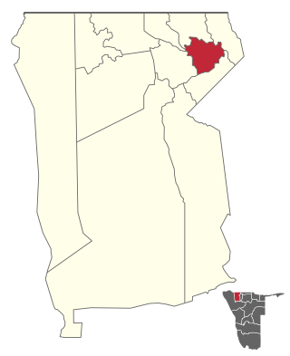
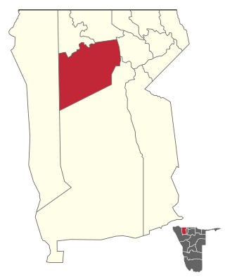
Tsumeb Constituency is an electoral constituency in the Oshikoto Region of Namibia, comprising the town area and surroundings of Tsumeb. It had a population of 44,113 in 2004 and 19,065 registered voters in 2020.
