U.S. Route 43 (US 43) is a 410-mile-long (660 km) north–south United States Highway in the East South Central States of Alabama and Tennessee. It travels from Prichard, Alabama to Columbia, Tennessee. The highway's southern terminus is in Prichard, at an intersection with US 90. Its northern terminus is in Columbia, Tennessee, at an intersection with US 31/US 412/US 412 Bus.

State Route 385 is an east–west state highway in the western portion of Ohio. The western terminus of State Route 385 is at U.S. Route 33 in New Hampshire, at a signalized intersection that doubles as the southern terminus of State Route 196. State Route 385's eastern terminus is at State Route 117 in the unincorporated community of Roundhead, less than two blocks northwest of State Route 117's junction with State Route 235.
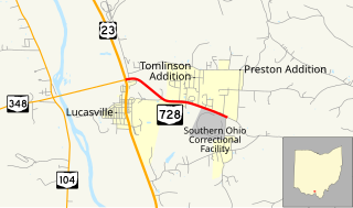
State Route 728 is a short east–west state highway situated in south-central Ohio. At a length of just under 2 miles (3.2 km), the state highway is a spur route that provides access to the Southern Ohio Correctional Facility. The western terminus of SR 728 is at a signalized intersection with U.S. Route 23 (US 23) in Lucasville that doubles as the eastern terminus of SR 348. Its eastern terminus is just east of the Southern Ohio Correctional Facility, at the intersection of Lucasville-Minford Road and Lang Lane (CR 180).

State Route 287 (SR 287) is a 13.69-mile-long (22.03 km) east–west state highway in the western portion of the U.S. state of Ohio. The western terminus of SR 287 is at SR 245 nearly 1.75 miles (2.82 km) east of West Liberty. Its eastern terminus is at an interchange with U.S. Route 33 (US 33) about 5.25 miles (8.45 km) northeast of North Lewisburg that dually serves as the southern terminus of SR 739.

State Route 621 is a north–south state highway in the central part of the U.S. state of Ohio. The southern terminus of SR 621 is at U.S. Route 36 approximately two and a half miles (4.0 km) northeast of Coshocton, and its northern terminus is adjacent to the North Appalachian Experimental Watershed Station, just north of its intersection with White Eyes Township Road 188, about 5 miles (8.0 km) northwest of the hamlet of Fresno. Continuing north after SR 621 ends is County Road 190.
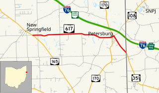
State Route 617 is a short east–west state route in northeastern Ohio, existing entirely within Springfield Township, Mahoning County. The western terminus of SR 617 is at SR 165 in the unincorporated community of New Springfield. Its eastern terminus is at the Pennsylvania State Line just southeast of the hamlet of Petersburg, where SR 617 turns into Pennsylvania Route 351 (PA 351).

State Route 288 (SR 288) is a 6.82-mile (10.98 km) long east–west state highway in the northern portion of the U.S. state of Ohio. The western terminus of SR 288 is at a T-intersection with SR 309 about 3 miles (4.8 km) southwest of Galion. Its eastern terminus is also at a T-intersection, this time with SR 97 approximately 5.50 miles (8.85 km) northwest of Lexington.
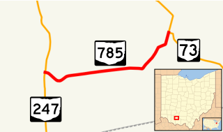
State Route 785 is a short east–west state highway in the southern portion of the U.S. state of Ohio. The western terminus of SR 785 is at SR 247 7.75 miles (12.47 km) north of Seaman in the community of Fairfax. Its eastern terminus is at its junction with SR 73 approximately nine miles (14 km) west of Sinking Spring in the community of Belfast.
State Route 46 (SR 46) is a 21.074-mile-long (33.915 km) state highway in Cleburne County in the eastern part of the U.S. state of Alabama. The western terminus of the highway is at an intersection with U.S. Route 78 (US 78) in Heflin. The eastern terminus of the route is at the Georgia state line, east of Ranburne, where the roadway continues as Georgia State Route 166.
State Route 146 (SR 146) is a 6.334-mile-long (10.194 km) state highway that exists entirely within Jackson County in the northeastern part of the U.S. state of Alabama. The western terminus of the highway is at an intersection with SR 65 in Swaim, an unincorporated community. The eastern terminus of the highway is at an intersection with SR 79 between Skyline and Hytop.
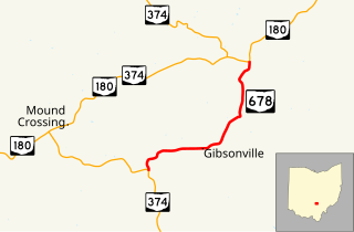
State Route 678 is a short four-mile-long (6.4 km) north–south state highway located in southeast Ohio. Entirely situated within Laurel Township in Hocking County, SR 678 has its southern terminus at SR 374 approximately one and a half miles (2.4 km) southwest of the hamlet of Gibisonville, and its northern terminus is at SR 180 nearly two and a half miles (4.0 km) northeast of Gibisonville. SR 678 provides a shorter alternative for traffic using SR 374 en route from Hocking Hills State Park up to U.S. Route 33 (US 33) at Rockbridge, in conjunction with SR 180.
State Route 136 (SR 136) is a 6.151-mile (9.899 km) state highway in Monroe County in the southwestern part of the U.S. state of Alabama. The western terminus of the highway is at an intersection with SR 21 south of Monroeville. The eastern terminus of the route is at an intersection with U.S. Route 84 and SR 41 near the Monroe–Conecuh county line, at a point east of Excel.
State Route 102 (SR 102) is a 24.281-mile-long (39.076 km) east–west state highway in the western part of the U.S. state of Alabama. The western terminus of the highway is at an intersection with U.S. Route 43 (US 43) approximately six miles (9.7 km) north of Fayette. The eastern terminus of the highway is at an intersection with SR 124 in Townley in western Walker County.

State Route 644 is a north–south state highway running through Columbiana and Carroll counties in northeast Ohio. Its southern terminus is at SR 39 in downtown Salineville, and its northern terminus is at its junction with U.S. Route 30(US 30) and SR 9 in the center of Kensington. The route connects mainly rural and a few unincorporated parts of southeastern Columbiana County. SR 644 only briefly passes into a corner of Carroll County for a 0.41-mile (0.66 km) journey.

State Route 706 is an east–west state route in western Ohio. The western terminus of SR 706 is at SR 29 in the hamlet of Pasco, and its eastern terminus is at a T-intersection with SR 235 just south of Quincy.
State Route 156 (SR 156) is a 7.186-mile (11.565 km) state highway that serves as a connection between Jachin and Pennington in northeastern Choctaw County. SR 156 intersects SR 17 at its western terminus and SR 114 at its eastern terminus.
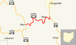
State Route 537 is a short east–west state highway in southeastern Ohio. At a length of just shy of five miles (8.0 km), SR 537 is located entirely within southwestern Monroe County. The state route's western terminus is at SR 260 approximately three and a half miles (5.6 km) southeast of the unincorporated community of Sycamore Valley, and its eastern terminus is at SR 26 one mile (1.6 km) south of the village limits of Graysville.

State Route 155 is an east–west state highway in the southeastern portion of the U.S. state of Ohio. The highway's western terminus is at SR 93 in Shawnee. Its eastern terminus is at a four-way stop intersection with SR 13 in Corning.

State Route 672 (SR 672) is a 3.11-mile-long (5.01 km) east–west state highway in the southeastern part of the U.S. state of Ohio. The highway runs from its western terminus at a Y-intersection with SR 146 nearly 1.75 miles (2.82 km) northeast of Cumberland to its eastern terminus at a T-intersection with SR 821 about 3 miles (4.8 km) southwest of the village of Pleasant City.
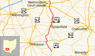
State Route 753 is a state highway in Ohio. The route is 35.35 miles (56.89 km) long and is located in eastern Highland County and southeastern Fayette County. The route's southern terminus is at an intersection with SR 41 in Brush Creek Township and its northern terminus is at an intersection with U.S. Route 62 and SR 3 on the border of Washington Court House and Union Township.