State Route 778 is a short north–south state highway in northern Ohio. The southern terminus of SR 778 is at SR 101 approximately 9 miles (14 km) northeast of Tiffin. The highway's northern terminus is at SR 19 about 3 miles (4.8 km) south of Green Springs. The route was created in 1942 and has not changed since.

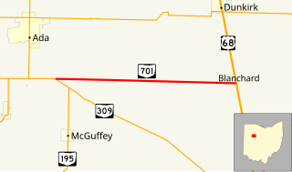
State Route 701 is a 8.96-mile (14.42 km) east–west state highway in western Ohio, a U.S. state. The state highway's western terminus is at a T-intersection with SR 309 nearly 3 miles (4.8 km) southeast of Ada. The eastern terminus of State Route 701 is at U.S. Route 68 (US 68) approximately 3.50 miles (5.63 km) southeast of Dunkirk.
State Route 365 (SR 365) is a very short two-lane east–west state highway in western Ohio. Its western terminus is at a T-intersection with the SR 235/SR 366 concurrency one mile (1.6 km) north of the village of Lakeview. After running east and south for less than 980 feet (300 m), the highway arrives at its eastern terminus in Indian Lake State Park, serving a boat launch on the western shore of Indian Lake.

State Route 287 (SR 287) is a 13.69-mile-long (22.03 km) east–west state highway in the western portion of the U.S. state of Ohio. The western terminus of SR 287 is at SR 245 nearly 1.75 miles (2.82 km) east of West Liberty. Its eastern terminus is at an interchange with U.S. Route 33 (US 33) about 5.25 miles (8.45 km) northeast of North Lewisburg that dually serves as the southern terminus of SR 739.

State Route 161 (SR 161) is an east–west state highway in central Ohio. Its western terminus is in Mutual at State Route 29 and its eastern terminus is near Alexandria at State Route 37. It is 57.46 miles (92.47 km) long. State Route 161 passes through Columbus, Ohio's capital, and a variety of towns including Plain City, Dublin, and New Albany.

State Route 372 (SR 372) is a very short, two-lane east–west state highway in the southern part of the U.S. state of Ohio. The western terminus of this spur route is at a T-intersection with the concurrency of U.S. Route 23 (US 23) and SR 104 about six and a half miles (10.5 km) north of Waverly. Its eastern terminus is just 0.68 miles (1.09 km) to the east of that point at the boundary of Scioto Trail State Forest. Continuing east of that point is Stoney Creek Road, which traverses through the state forest in the direction of the Scioto River. From its inception in the middle of the 1930s, the primary function of SR 372 has been to provide access to the state forest from the state highway system.

State Route 671 is an east-west state highway in the southern portion of Ohio. Existing entirely within Vinton County, the western terminus of this short connector route is at SR 327 three miles (4.8 km) northeast of the hamlet of Londonderry. Its eastern terminus is at U.S. Route 50 (US 50) in the unincorporated community of Ratcliffburg.

State Route 446 is an east–west state highway in the northeastern portion of the U.S. state of Ohio. The western terminus of SR 446 is at a T-intersection with U.S. Route 224 (US 224) in Canfield, approximately one mile (1.6 km) west of the downtown area. Its eastern terminus is at a Y-intersection with SR 46 about one mile (1.6 km) south of Canfield.

State Route 709 is an east–west state route in western Ohio. SR 709 exists entirely in southern Van Wert County. Its western terminus is at SR 118 in Ohio City, and its eastern terminus is at SR 116 just south of Venedocia.

State Route 814 is a 3-mile (5 km), north–south state route in western Ohio. The entirety of SR 814 lies within Champaign County. The southern terminus of SR 814 is at U.S. Route 36 (US 36) approximately three miles (4.8 km) east of Urbana, and its northern terminus is at SR 296 about five and a half miles (8.9 km) northeast of Urbana. The SR 814 designation came about during the early 1980s, being re-numbered from State Route 714 following a major issue with SR 714 shields continually disappearing.

State Route 566 is a north–south state highway in eastern Ohio, a U.S. state. Located exclusively in northern Noble County, SR 566 has its southern terminus at SR 147, at a T-intersection 1.25 miles (2.01 km) north of the unincorporated community of Mount Ephraim. Its northern terminus is at another T-intersection, this time with SR 285 approximately 1.25 miles (2.01 km) south of the village of Senecaville.

State Route 746 is a north–south thirteen-mile-long (21 km) state highway located in central Ohio, a U.S. state. Its southern terminus is at U.S. Route 42 (US 42) approximately three miles (4.8 km) north of Ashley, and its northern terminus is at SR 309 in Caledonia.

State Route 644 is a north–south state highway running through Columbiana and Carroll counties in northeast Ohio. Its southern terminus is at SR 39 in downtown Salineville, and its northern terminus is at its junction with U.S. Route 30(US 30) and SR 9 in the center of Kensington. The route connects mainly rural and a few unincorporated parts of southeastern Columbiana County. SR 644 only briefly passes into a corner of Carroll County for a 0.41-mile (0.66 km) journey.

State Route 310 (SR 310) is a north–south state route in the central portion of Ohio. The highway extends 13.99 miles (22.51 km) from its southern terminus at SR 204 south of the hamlet of Etna to the northern terminus at SR 37 approximately two miles (3.2 km) southeast of Johnstown.

State Route 706 is an east–west state route in western Ohio. The western terminus of SR 706 is at SR 29 in the hamlet of Pasco, and its eastern terminus is at a T-intersection with SR 235 just south of Quincy.

State Route 187 (SR 187) is a 8.22-mile (13.23 km) north–south state highway in the central portion of the U.S. state of Ohio. The southern terminus of SR 187 is at a T-intersection with SR 56 approximately 4.25 miles (6.84 km) northwest of London. Its northern terminus is at a T-intersection with SR 29 about one mile (1.6 km) to the southeast of Mechanicsburg.

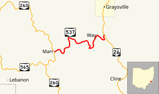
State Route 537 is a short east–west state highway in southeastern Ohio. At a length of just shy of five miles (8.0 km), SR 537 is located entirely within southwestern Monroe County. The state route's western terminus is at SR 260 approximately three and a half miles (5.6 km) southeast of the unincorporated community of Sycamore Valley, and its eastern terminus is at SR 26 one mile (1.6 km) south of the village limits of Graysville.

State Route 363 is a short north–south state highway located in west-central Ohio. The southern terminus of this spur route is along the shores of Lake Loramie approximately two and a half miles (4.0 km) southeast of Minster, where the roadway becomes known as Lotus Road. The northern terminus of SR 363 is at a T-intersection with SR 119 about one mile (1.6 km) east of Minster.

State Route 245 (SR 245) is an east–west state highway in the western portion of the U.S. state of Ohio. The western terminus of SR 245 is at an intersection with SR 29 near Rosewood. Its eastern terminus is at an exit ramp with U.S. Route 33 (US 33), US 36, and SR 4 in Marysville.

State Route 296 is a 10.54-mile (16.96 km) long state highway entirely in Champaign County, Ohio. Routed around the northern side of Urbana, the route runs in two townships, Salem Township and Wayne Township.


