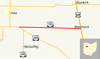
State Route 701 is a 8.96-mile (14.42 km) east–west state highway in western Ohio, a U.S. state. The state highway's western terminus is at a T-intersection with SR 309 nearly 3 miles (4.8 km) southeast of Ada. The eastern terminus of State Route 701 is at U.S. Route 68 (US 68) approximately 3.50 miles (5.63 km) southeast of Dunkirk.
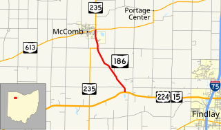
State Route 186 is a north–south state highway in the northwestern part of the U.S. state of Ohio. Traveling through mostly rural areas, State Route 186 has its southern terminus at a T-intersection with the U.S. Route 224/State Route 15 concurrency nearly 3.5 miles (5.6 km) south-southeast of McComb. Following a 1-mile (1.6 km) long concurrency with State Route 235 into McComb, State Route 186 arrives at its northern terminus at its junction with State Route 613. North of State Route 613, State Route 235 carries on as a solo route.

State Route 638 is a two-lane north–south state highway in the west central portion of Ohio, a U.S. state. SR 638 has its southern terminus at an intersection with U.S. Route 68 (US 68) just over six miles (9.7 km) north of the city of Bellefontaine. The northern terminus of the route is at SR 273 at the extreme southeastern corner of the village of Belle Center.
State Route 365 (SR 365) is a very short two-lane east–west state highway in western Ohio. It is currently the shortest signed state route in Ohio. Its western terminus is at a T-intersection with the SR 235/SR 366 concurrency one mile (1.6 km) north of the village of Lakeview. After running east and south for less than 980 feet (300 m), the highway arrives at its eastern terminus in Indian Lake State Park, serving a boat launch on the western shore of Indian Lake.
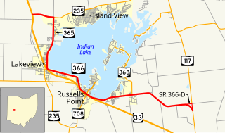
State Route 366 is an east–west state highway in the western portion of the U.S. state of Ohio. SR 366 has its western terminus at a T-intersection with U.S. Route 33 nearly 1.50 miles (2.41 km) northwest of Lakeview. The route's eastern terminus is at State Route 117 about 1.50 miles (2.41 km) north of Huntsville. SR 366 runs along the western and southern edge of Indian Lake and provides access to homes and recreational facilities along the lake shoreline. SR 366 was designated in 1939, and was extended in 1961.

State Route 287 (SR 287) is a 13.69-mile-long (22.03 km) east–west state highway in the western portion of the U.S. state of Ohio. The western terminus of SR 287 is at SR 245 nearly 1.75 miles (2.82 km) east of West Liberty. Its eastern terminus is at an interchange with U.S. Route 33 (US 33) about 5.25 miles (8.45 km) northeast of North Lewisburg that dually serves as the southern terminus of SR 739.

State Route 540 (SR 540) is an east–west state highway in the western portion of the U.S. state of Ohio. SR 540 has its western terminus in downtown Bellefontaine at a signalized intersection with U.S. Route 68 (US 68) and SR 47. Its eastern terminus is at a T-intersection with SR 292 approximately 3.50 miles (5.63 km) southwest of West Mansfield.

State Route 611 is an east–west state highway in the northern portion of the U.S. state of Ohio. The western terminus of SR 611 is at a partial interchange with US 6 in Lorain. Its eastern terminus is at a signalized intersection with SR 254 in Avon.

State Route 554 is an east–west state highway located in the southeastern corner of Ohio, a U.S. state. The western terminus of State Route 554 is at State Route 325 about 1 mile (1.6 km) north of Rio Grande, and just 1 block north of the State Route 325 interchange off of U.S. Route 35. Its eastern terminus is at a signalized intersection with State Route 7 in Cheshire a mere two blocks west of the Ohio River.

State Route 274 is a two-lane east–west state highway located in the western portion of the U.S. state of Ohio. The western terminus of State Route 274 is at a T-intersection with U.S. Route 127 approximately 4 miles (6.4 km) west of Chickasaw. Its eastern terminus is at another T-intersection, this time with State Route 273 about 3.5 miles (5.6 km) northeast of Rushsylvania.

State Route 559 is a north–south state highway in the central portion of the U.S. state of Ohio. The southern terminus of the highway is at the signalized junction of State Route 29 and State Route 4 in downtown Mechanicsburg. Its northern terminus is at a T-intersection with State Route 287 approximately 4 miles (6.4 km) northwest of North Lewisburg.
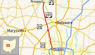
State Route 257 is a 26.19-mile (42.15 km) north - south state highway in the central portion of the U.S. state of Ohio. The highway's southern terminus is in the northwestern Columbus suburb of Dublin at a roundabout intersection with U.S. Route 33 and SR 161. This mainly two-lane highway follows the eastern side of the Scioto River from Dublin to its junction with US 42. After crossing over the river with the U.S. highway, SR 257 parallels the river's western bank. SR 257 has its northern terminus at a T-intersection with SR 47 on the western village limits of Prospect. SR 257 was created in 1926, and extended in 1935 and 1937.

State Route 507 is a short east–west state route in western Ohio, located entirely in the northern portion of Champaign County. The western terminus of SR 507 is at U.S. Route 68 (US 68) one mile (1.6 km) south of West Liberty. Its eastern terminus is at SR 245 near the Ohio Caverns approximately four miles (6.4 km) southeast of West Liberty.

State Route 749 is an east–west state highway in the southwestern portion of the U.S. state of Ohio. Its western terminus is at a signalized intersection with US 52 in the hamlet of New Palestine, and its eastern terminus is at another signalized intersection, this time SR 132, in the unincorporated community of Lindale.

State Route 720 is an east–west state highway in the western portion of the U.S. state of Ohio. The highway runs from its western terminus at SR 65 approximately 3.75 miles (6.04 km) north of Jackson Center to its eastern terminus at US 33 in Russells Point.
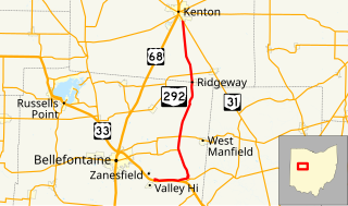
State Route 292 is a two-lane north–south state highway in the western portion of the U.S. state of Ohio. The southern terminus of the highway is at a diamond interchange with the U.S. Route 33 (US 33) expressway approximately one mile (1.6 km) southeast of the village of Zanesfield. Its northern terminus is at a Y-intersection with SR 31 just south of the city limits of Kenton.

State Route 706 is an east–west state route in western Ohio. The western terminus of SR 706 is at SR 29 in the hamlet of Pasco, and its eastern terminus is at a T-intersection with SR 235 just south of Quincy.

State Route 229 is an east-west state highway in the central part of the U.S. state of Ohio. The western terminus of State Route 229 is at a T-intersection with State Route 47 just 0.25 miles (0.40 km) south of the village limits of Waldo. Its eastern terminus is more than 50 miles (80 km) to the east at a T-intersection with U.S. Route 36 about 5.5 miles (8.9 km) west of the village of Nellie.

State Route 347 (SR 347) is an east–west state highway in central portion of the U.S. state of Ohio. The western terminus of SR 347 is at SR 287 near Middleburg, adjacent to the U.S. Route 33 freeway. Its eastern terminus is at a T-intersection with SR 37 just one-quarter mile (0.40 km) south of the village of Magnetic Springs. The route runs through rural areas of Logan and Union counties passing through no incorporated villages.

State Route 520 is an east–west state highway in the central part of Ohio. SR 520's western terminus is at a T-intersection with SR 514 about 4 miles (6.4 km) southwest of Nashville. The highway's eastern terminus is also at a T-intersection, this time with US 62 just 0.5 miles (0.80 km) southwest of the village Killbuck and US 62's junction with SR 60. SR 520 provides access to the village of Glenmont.

