
State Route 600 is an east–west state highway in the northwestern portion of the U.S. state of Ohio. The western terminus of State Route 600 is at US 23 about 5 miles (8.0 km) west of Gibsonburg. Its eastern terminus is at US 20 in the unincorporated community of Hessville approximately 4.25 miles (6.84 km) east of Gibsonburg.

State Route 531 is an east–west state highway in the U.S. state of Ohio. The western terminus of State Route 531 is at the northern terminus of State Route 534 in Geneva-on-the-Lake, at a curve along Lake Road. The route's eastern terminus is at the northern terminus of State Route 7, at a signalized intersection in Conneaut.

State Route 508 is a two-lane east-west state highway in the western portion of Ohio, a U.S. state. The western terminus of State Route 508 is at a signalized intersection with State Route 235 in the village of De Graff. The route's eastern terminus is at a T-intersection with U.S. Route 68 in West Liberty.

State Route 611 is an east–west state highway in the northern portion of the U.S. state of Ohio. The western terminus of SR 611 is at a partial interchange with US 6 in Lorain. Its eastern terminus is at a signalized intersection with SR 254 in Avon.

State Route 554 is an east–west state highway located in the southeastern corner of Ohio, a U.S. state. The western terminus of State Route 554 is at State Route 325 about 1 mile (1.6 km) north of Rio Grande, and just 1 block north of the State Route 325 interchange off of U.S. Route 35. Its eastern terminus is at a signalized intersection with State Route 7 in Cheshire a mere two blocks west of the Ohio River.

State Route 183 is a north/south state Highway in eastern Ohio. Its southern terminus is SR 800 in Sandy Township, approximately 0.5 miles (0.80 km) east of Sandyville and less than two miles (3.2 km) south of East Sparta. Its northern terminus is SR 14 in Edinburg Township near Interstate 76, about 10 miles (16 km) southeast of Ravenna. The current route was commissioned in 1962.

State Route 519 is an east–west state highway situated in eastern Ohio, a U.S. state. The highway runs from its western terminus at U.S. Route 22 approximately 6 miles (9.7 km) northwest of New Athens to its eastern terminus at U.S. Route 250 about 1 mile (1.6 km) northwest of Harrisville.

State Route 507 is a short east–west state route in western Ohio, located entirely in the northern portion of Champaign County. The western terminus of SR 507 is at U.S. Route 68 (US 68) one mile (1.6 km) south of West Liberty. Its eastern terminus is at SR 245 near the Ohio Caverns approximately four miles (6.4 km) southeast of West Liberty.

State Route 297 is a short north–south state highway in the northeastern portion of the U.S. state of Ohio. Its southern terminus is at a long interchange with U.S. Routes 30 and 62 in Perry and Canton township, and its signed northern terminus is at SR 172 at the intersection of Raff Avenue and Tuscarawas Street in western on the border of Perry Township and the city of Canton. SR 297 continues, unsigned, one-half mile (0.80 km) west along SR 172 to its intersection with Whipple Avenue.

State Route 749 is an east–west state highway in the southwestern portion of the U.S. state of Ohio. Its western terminus is at a signalized intersection with US 52 in the hamlet of New Palestine, and its eastern terminus is at another signalized intersection, this time SR 132, in the unincorporated community of Lindale.

State Route 323 is an east–west state highway in southwestern Ohio. State Route 323's western terminus is at State Route 41 in South Solon. Its eastern terminus is at State Route 56 just northwest of Mount Sterling.

State Route 660 is an east–west state highway in the east-central portion of Ohio. Existing entirely within Guernsey County, the western terminus of State Route 660 is at State Route 313 just east of the hamlet of Claysville. Its eastern terminus is at a signalized T-intersection with State Route 209 near Cambridge Municipal Airport, 1.25 miles (2.01 km) south of the city limits of Cambridge, as well as State Route 209's interchange off of Interstate 70.

State Route 517 is an east–west state highway located in the northeastern quadrant of the U.S. state of Ohio. The western terminus of State Route 517 is in downtown Lisbon at a signalized intersection that marks the confluence of U.S. Route 30, State Route 45, State Route 154 and State Route 164. The eastern terminus is at the junction of State Route 7 and State Route 558 approximately 2 miles (3.2 km) north of the village of Rogers.
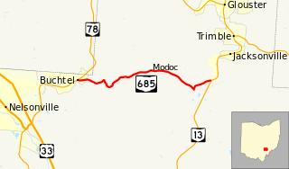
State Route 685 is a short east–west state highway in southeastern Ohio, a U.S. state. The western terminus of SR 685 is at SR 78 in the village of Buchtel. Its eastern terminus is at SR 13 approximately one mile (1.6 km) southwest of Jacksonville.

State Route 211 (SR 211) is a 1.23-mile-long (1.98 km) north–south state highway in the eastern portion of the U.S. state of Ohio. Though physically it runs in a northwesterly–southeasterly direction, according to the Ohio Department of Transportation (ODOT) and signage on the route itself its southern terminus is located north of its northern terminus. The unusual directional signage is a vestige of when SR 211 traveled further south acting as a bypass of New Philadelphia and Dover. The highway runs from its signed southern terminus at a signalized intersection with SR 39 on the border of the city of Dover and Dover Township, just one block east of exit 83 off the Interstate 77 (I-77)/U.S. Route 250 (US 250) freeway, to its signed northern terminus at a signalized intersection with SR 800 near downtown Dover.
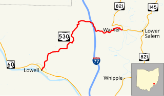
State Route 530 is a nearly 8-mile (13 km) long, east-west state highway in the southeastern corner of the U.S. state of Ohio. The western terminus of State Route 530 is at a signalized T-intersection with State Route 60 in downtown Lowell. Its eastern terminus is at State Route 821 in the community of Warner, nearly 1 mile (1.6 km) west of Lower Salem.

State Route 751 is an east–west state highway located in the east-central portion of Ohio. The highway runs between its western terminus at SR 93 in West Lafayette and its eastern terminus at a diamond interchange with I-77 on the outskirts of the village of Stone Creek.

State Route 212 is a two-lane east–west state highway that runs within Stark, Tuscarawas, Carroll, and Harrison Counties in eastern Ohio. The western terminus of SR 212 is at U.S. Route 250 near Beach City, and its eastern terminus is at SR 151 in Bowerston. The route passes through rural areas but passes through small villages including Beach City, Bolivar, Zoar, Sherrodsville, and Leesville. It largely follows the valleys formed by the Tuscarawas River and Conotton Creek.
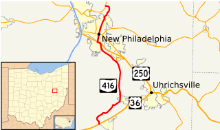
State Route 416 is a north–south state highway in the east-central portion of Ohio. The southern terminus of State Route 416 is at a T-intersection with U.S. Route 36 just west of Gnadenhutten. Its northern terminus is at a T-intersection with State Route 800 approximately 2 miles (3.2 km) east of Dover.
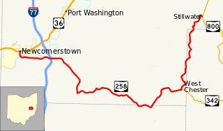
State Route 258 is a state highway that runs 25.64 miles (41.26 km) in eastern Ohio. It travels from US 36 in Newcomerstown to SR 800 in Rush Township community of Stillwater. Most of the route is in Tuscarawas County but the route briefly enters Guernsey and Harrison Counties.

