State Route 21 (SR 21) is a north–south state highway in the northeastern portion of the U.S. state of Ohio. The southern terminus of SR 21 is north of Strasburg on U.S. Route 250. The northern terminus of SR 21 is at an interchange with Interstate 77 in Cuyahoga Heights.
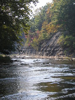
The Huron River is a 14.9-mile-long (24.0 km) waterway in the north central Ohio in the United States. The watershed drains large portions of Erie County and Huron County, the northeast corners of Seneca County and Crawford County, and northern portions of Richland County.

State Route 638 is a two-lane north–south state highway in the west central portion of Ohio, a U.S. state. SR 638 has its southern terminus at an intersection with U.S. Route 68 (US 68) just over six miles (9.7 km) north of the city of Bellefontaine. The northern terminus of the route is at SR 273 at the extreme southeastern corner of the village of Belle Center.

State Route 708 (SR 708) is a short two-lane north–south state route that runs exclusively within Logan County, Ohio. The southern terminus of SR 708 approximately two miles (3.2 km) south of Russells Point at SR 235, near the Russells Point Honda manufacturing facility, and its northern terminus is just north of Russells Point at Indian Lake State Park, where the highway becomes Township Road 253 on Orchard Island.

State Route 287 (SR 287) is a 13.69-mile-long (22.03 km) east–west state highway in the western portion of the U.S. state of Ohio. The western terminus of SR 287 is at SR 245 nearly 1.75 miles (2.82 km) east of West Liberty. Its eastern terminus is at an interchange with U.S. Route 33 (US 33) about 5.25 miles (8.45 km) northeast of North Lewisburg that dually serves as the southern terminus of SR 739.
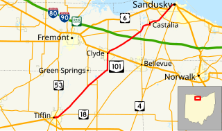
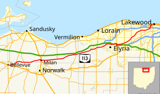
State Route 101 (SR 101) is a southwest-northeast state highway in the north central portion of the U.S. state of Ohio. Its western terminus is at the junction of SR 18 and SR 53 in Tiffin; it runs concurrently with SR 18 for about one mile (1.6 km). Its eastern terminus is at the junction of U.S. Route 6 (US 6) and SR 4 in Sandusky; it runs concurrently with US 6 for just over one and a half miles (2.4 km) to its western terminus.

State Route 510 is a north–south state highway in the northern portion of Ohio. The entirety of SR 510 lies within Sandusky County. Its southern terminus is at SR 101 in Clyde, and its northern terminus is at U.S. Route 6 (US 6) between Fremont and Sandusky.

State Route 745 (SR 745) is a state route in central Ohio that runs in a north-northwesterly direction along the west bank of the Scioto River. Its southern terminus is at the concurrency of U.S. Route 33 (US 33) and SR 161 in Dublin, and it runs for approximately ten miles (16 km) to Concord Township in Delaware County, where it arrives at its northern terminus at the concurrency of US 42 and SR 257. SR 745 was designated in 1937, and its routing has not changed since.

State Route 515 is a north-south state highway located in east-central Ohio. Existing entirely within the northeastern portion of Holmes County in Ohio's Amish Country, SR 515 has its southern terminus at a signalized intersection with SR 39 in the unincorporated community of Walnut Creek. Its northern terminus is at a T-intersection with U.S. Route 62 (US 62) one mile (1.6 km) southwest of the hamlet of Winesburg.

State Route 99 (SR 99) is a north–south state highway in the north-central portion of the U.S. state of Ohio. The highway's southern terminus is in the southern end of Willard at a T-intersection with U.S. Route 224 (US 224). Its northern terminus is at its junction with SR 4 about 6 miles (9.7 km) southwest of the city limits of Sandusky.
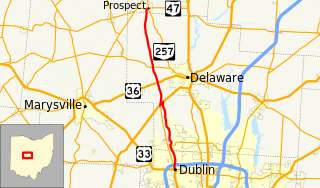
State Route 257 is a 26.19-mile (42.15 km) north - south state highway in the central portion of the U.S. state of Ohio. The highway's southern terminus is in the northwestern Columbus suburb of Dublin at a roundabout intersection with U.S. Route 33 and SR 161. This mainly two-lane highway follows the eastern side of the Scioto River from Dublin to its junction with US 42. After crossing over the river with the U.S. highway, SR 257 parallels the river's western bank. SR 257 has its northern terminus at a T-intersection with SR 47 on the western village limits of Prospect. SR 257 was created in 1926, and extended in 1935 and 1937.

State Route 61 is a north–south state highway in the northern portion of the U.S. state of Ohio. Its southern terminus is at the U.S. Route 36/State Route 3 concurrency in Sunbury, and its northern terminus is at U.S. Route 6 east of Huron, at the southernmost point of Lake Erie. State Route 61 is routed through the communities of Mount Gilead, Galion, Crestline, Shelby, Plymouth, Norwalk, and Berlin Heights.

State Route 709 is an east–west state route in western Ohio. SR 709 exists entirely in southern Van Wert County. Its western terminus is at SR 118 in Ohio City, and its eastern terminus is at SR 116 just south of Venedocia.

State Route 746 is a north–south thirteen-mile-long (21 km) state highway located in central Ohio, a U.S. state. Its southern terminus is at U.S. Route 42 (US 42) approximately three miles (4.8 km) north of Ashley, and its northern terminus is at SR 309 in Caledonia.

State Route 644 is a north–south state highway running through Columbiana and Carroll counties in northeast Ohio. Its southern terminus is at SR 39 in downtown Salineville, and its northern terminus is at its junction with U.S. Route 30(US 30) and SR 9 in the center of Kensington. The route connects mainly rural and a few unincorporated parts of southeastern Columbiana County. SR 644 only briefly passes into a corner of Carroll County for a 0.41-mile (0.66 km) journey.

State Route 310 (SR 310) is a north–south state route in the central portion of Ohio. The highway extends 13.99 miles (22.51 km) from its southern terminus at SR 204 south of the hamlet of Etna to the northern terminus at SR 37 approximately two miles (3.2 km) southeast of Johnstown.
U.S. Route 250 (US 250) is a United States Numbered Highway that runs from Sandusky, Ohio to Richmond, Virginia. Within the state of Ohio, the route runs from US 6 in Sandusky to the West Virginia border at Bridgeport.

U.S. Route 6 is a part of the United States Numbered Highway System that runs from Bishop, California to Provincetown, Massachusetts. US 6 is the second longest federal highway in the United States, second only to U.S. Route 20. In Ohio, the road runs west-east from the Indiana state line near Edgerton to the Pennsylvania state line near Andover. The 248.002 miles (399.121 km) that lie in Ohio are maintained by the Ohio Department of Transportation (ODOT). US 6 serves the major cities of Sandusky, Lorain, and Cleveland. The highway is also called the Grand Army of the Republic Highway to honor the Union forces of the American Civil War. The alternate name was designated in 1953.
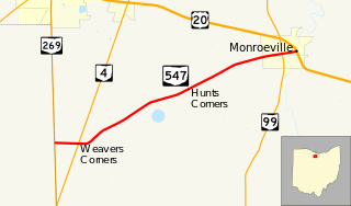
State Route 547 is an east–west state highway in north central Ohio, a U.S. state. The highway's western terminus is at SR 269 approximately four and a half miles (7.2 km) south of Bellevue. The eastern terminus of SR 547 is at the concurrency of U.S. Route 20 (US 20) and SR 18 in downtown Monroeville.
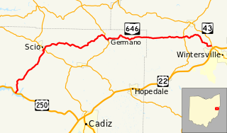
State Route 646 is a 28.78-mile-long (46.32 km) state highway in Harrison and Jefferson Counties in eastern Ohio. The route runs from US 250 in Stock Township, northwest of Cadiz, to SR 43 in Island Creek Township, just outside Wintersville.