State Route 330 is a north–south state highway in the northwestern portion of the U.S. state of Ohio. The southern terminus of SR 330 is at a diamond interchange with the SR 15 expressway just south of the village limits of Vanlue. Its northern terminus is at SR 568 nearly 1.75 miles (2.82 km) north of Vanlue.

State Route 545 (SR 545) is a 17.01-mile (27.37 km) long north–south state highway in the northern portion of the U.S. state of Ohio. The southern terminus of SR 545 is at a T-intersection with SR 39 in the city of Mansfield. Its northern terminus is at the U.S. Route 250 (US 250) and SR 60 concurrency in the village of Savannah.

State Route 532 is a north–south state highway in the northeastern portion of the U.S. state of Ohio. The highway runs from its southern terminus at a signalized intersection with U.S. Route 224 (US 224) on the Summit–Portage county line approximately 0.75 miles (1.21 km) south of Mogadore on the border of Springfield Township and Suffield Township to its northern terminus at a diamond interchange with Interstate 76 (I-76), at its exit 29 within the Tallmadge city limits.

State Route 81 is an east–west route in western Ohio. Its western terminus is at the Indiana state line near Willshire, and its eastern terminus is at SR 53 in Patterson. The route also goes through or close to the towns of Elgin, Lima, Ada, and Dunkirk.

State Route 306 is a north–south state highway in northeastern Ohio, running from its southern terminus at SR 43 in Aurora to its northern terminus at SR 283 in Mentor. Most of the road from Aurora north to Kirtland is part of the former Chillicothe Turnpike and is known as Chillicothe Road. The Kirtland Temple, the first temple built by the Latter Day Saint movement (Mormons), is located on Route 306 in central Kirtland.

State Route 26 is a 67-mile-long (108 km) north–south route in south eastern Ohio spanning from SR 7 in Marietta to SR 148 between Jerusalem and Bethesda. SR 26 also passes through Graysville and Woodsfield. Where the state route designation ends in Wayne Township, the road continues north as Belmont County Road 26 where it connects to the Barkcamp State Park and the National Road. Much of the route parallels the Little Muskingum River and travels through the heart of Wayne National Forest's Marietta Unit.

State Route 772 is a north–south state highway in the south-central portion of the U.S. state of Ohio. Its southern terminus is at SR 73 in Rarden. Leaving Rarden, the route increases in elevation to Mount Joy, the highest point in Scioto County. After weaving between Scioto and Pike County for about four miles (6.4 km), the route joins the Appalachian Highway, SR 32 and subsequently SR 124. Following these concurrences, SR 772 continues its journey north through scenic terrain and small communities until it reaches its northern terminus at the US 50 and SR 104 concurrence in Chillicothe.

State Route 99 (SR 99) is a north–south state highway in the north-central portion of the U.S. state of Ohio. The highway's southern terminus is in the southern end of Willard at a T-intersection with U.S. Route 224 (US 224). Its northern terminus is at its junction with SR 4 about 6 miles (9.7 km) southwest of the city limits of Sandusky.

State Route 56 is a west–east state highway in central Ohio. Its western terminus is at SR 29 near Mutual, and its eastern terminus is at SR 682 in Athens.

State Route 305 is a 33.99-mile (54.70 km) long east–west state highway in the northeastern portion of the U.S. state of Ohio. The western terminus of SR 305 is at a signalized intersection with the duplex of SR 82 and SR 700 in the village of Hiram. Its eastern terminus is at a five-way stop intersection on the Pennsylvania state line nearly 1.75 miles (2.82 km) south of Orangeville. Picking up where SR 305 leaves off heading southeast into Pennsylvania from this intersection is PA 718.

State Route 185 (SR 185) is a 21.70-mile (34.92 km) long east–west state highway in the western part of the U.S. state of Ohio. The western terminus of SR 185 is at U.S. Route 127 (US 127) approximately 3.75 miles (6.04 km) south of North Star. Its eastern terminus is in Piqua. Until 2011, this was at its junction with US 36 and SR 66 in the city's downtown business district, at the intersection of Ash Street and Spring Street. In 2011, SR 185 was re-routed to travel south along Sunset Drive in the western part of Piqua to a new eastern terminus where Sunset Drive meets US 36, which is known as Covington Avenue at that location.

State Route 138 is an east–west state highway in the southwestern portion of the U.S. state of Ohio. Its west terminus is at its intersection with SR 134 in Buford and its eastern terminus is at its intersection with US 22 east of Williamsport.

State Route 211 (SR 211) is a 1.23-mile-long (1.98 km) north–south state highway in the eastern portion of the U.S. state of Ohio. Though physically it runs in a northwesterly–southeasterly direction, according to the Ohio Department of Transportation (ODOT) and signage on the route itself its southern terminus is located north of its northern terminus. The unusual directional signage is a vestige of when SR 211 traveled further south acting as a bypass of New Philadelphia and Dover. The highway runs from its signed southern terminus at a signalized intersection with SR 39 on the border of the city of Dover and Dover Township, just one block east of exit 83 off the Interstate 77 (I-77)/U.S. Route 250 (US 250) freeway, to its signed northern terminus at a signalized intersection with SR 800 near downtown Dover.
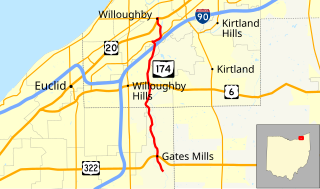
State Route 174 (SR 174) is a 9.56-mile (15.39 km) long north–south state highway in the northeastern quadrant of the U.S. state of Ohio. The highway runs from its southern terminus at a T-intersection with Old Mill Road in a quiet residential neighborhood in the eastern Cleveland suburb of Gates Mills to its northern terminus at a signalized intersection with U.S. Route 20 (US 20) in Willoughby that doubles as the eastern terminus of SR 640.

State Route 175 (SR 175) is a 15.70-mile (25.27 km) long north–south state highway in the northeastern part of the U.S. state of Ohio. The southern terminus of SR 175 is at a signalized intersection with SR 43 in Solon. Its northern terminus is at a signailzed intersection with SR 283 in Euclid.

State Route 560 (SR 560) is a 9.97-mile-long (16.05 km) north–south state highway in the western portion of Ohio, a U.S. state. SR 560 has its southern terminus at SR 55 approximately 3.50 miles (5.63 km) southwest of the county seat of Urbana. The northern terminus of the state route is at a T-intersection with SR 29 nearly 6 miles (9.7 km) southeast of the hamlet of Rosewood.

State Route 291 (SR 291) is a 4.14-mile-long (6.66 km) north–south state highway in the northeastern quadrant of the U.S. state of Ohio. The southern terminus of the highway is at a T-intersection with Fowles Road in Middleburg Heights, nearly 0.50 miles (0.80 km) west of where Fowles Road meets U.S. Route 42. Its northern terminus is at a signalized T-intersection with SR 17 on the border between Brook Park and Cleveland, immediately west of where SR 17 passes underneath Interstate 71 south of Interstate 480. It is known locally as Engle Road through its entire length.

State Route 362 is a 4.56-mile (7.34 km) north–south state highway in the western part of the U.S. state of Ohio. It serves to connect Lake Loramie State Park with SR 66. Its southern terminus is in Fort Loramie at the intersection of North Main Street (SR 66) and Elm Street. near the northern edge of Fort Loramie. SR 362 then runs about 1.1 miles (1.8 km) east, then turns north at its intersection with Fort Loramie–Swanders Road. SR 362 then runs northerly along the western edge of Lake Loramie and Lake Loramie State Park before turning northwesterly then westerly and enters Minster and reaches its northern terminus at the intersection of South Main Street (SR 66) and First Street.
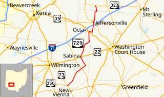
State Route 729 is a state highway in central Ohio. The 33.58-mile-long (54.04 km) route runs from SR 73 and SR 350 in the community of Snow Hill, northwest of New Vienna to SR 323 north of Jeffersonville.