Ohio State Route 685

Last updated

OH-685.svg

State Route 685
OH 685 map.svg
Route information
Maintained by ODOT
Length 5.24 mi [1] (8.43 km)
Existed 1937 – present
Major junctions
West endOH-78.svg SR 78 in Buchtel
North endOH-13.svg SR 13 near Jacksonville
Location
Counties Athens
Highway system
OH-684.svg SR 684 SR 686 OH-686 (1927).svg

State Route 685 (SR 685) is a short eastwest state highway in southeastern Ohio, a U.S. state. The western terminus of SR 685 is at SR 78 in the village of Buchtel. Its eastern terminus is at SR 13 approximately one mile (1.6 km) southwest of Jacksonville.

A state highway, state road, or state route is usually a road that is either numbered or maintained by a sub-national state or province. A road numbered by a state or province falls below numbered national highways in the hierarchy. Roads maintained by a state or province include both nationally numbered highways and un-numbered state highways. Depending on the state, "state highway" may be used for one meaning and "state road" or "state route" for the other.

Ohio State of the United States of America

Ohio is a Midwestern state in the Great Lakes region of the United States. Of the fifty states, it is the 34th largest by area, the seventh most populous, and the tenth most densely populated. The state's capital and largest city is Columbus.

U.S. state constituent political entity of the United States

In the United States, a state is a constituent political entity, of which there are currently 50. Bound together in a political union, each state holds governmental jurisdiction over a separate and defined geographic territory and shares its sovereignty with the federal government. Due to this shared sovereignty, Americans are citizens both of the federal republic and of the state in which they reside. State citizenship and residency are flexible, and no government approval is required to move between states, except for persons restricted by certain types of court orders. Four states use the term commonwealth rather than state in their full official names.

Contents

Existing in the northern portion of Athens County, SR 685 functions as a connector route between SR 78 and SR 13 as it makes its way through the Wayne National Forest. The designation of SR 685 came into being in the early 1960s, replacing what had been known as SR 675, due to the construction of Interstate 675 in the Dayton vicinity, and the fact that Ohio does not duplicate numbers among different types of highways.

Athens County, Ohio County in the United States

Athens County is a county in southeastern Ohio. As of the 2010 census, the population was 64,757. Its county seat is Athens. The county was formed in 1805 from Washington County. Because the original state university was founded there in 1804, the town and the county were named for the ancient center of learning, Athens, Greece.

Wayne National Forest protected area in Ohio, USA

The Wayne National Forest is located in the south-eastern part of the US state of Ohio, in the Unglaciated Allegheny Plateau. It is the only national forest in Ohio. Forest headquarters are located between The Plains and Nelsonville, Ohio, on US Route 33, overlooking the Hocking River.

Interstate 675 (Ohio) highway in Ohio

Interstate 675 (I-675) is an auxiliary interstate highway in the suburbs of Dayton in the U.S. state of Ohio. Interstate 675 serves as an eastern bypass of Dayton. I-675 measures 26.53 miles (42.70 km) in length. As originally proposed, the route was to reconnect with I-75 north of Dayton near Northridge rather than going east towards Springfield and I-70. Construction was completed in 1987, though some have lobbied to extend the highway west of Dayton.

Route description

All of SR 685 is located in the northern portion of Athens County. This state highway is not included as a part of the National Highway System. [2]

National Highway System (United States) highway system in the United States

The National Highway System (NHS) is a network of strategic highways within the United States, including the Interstate Highway System and other roads serving major airports, ports, rail or truck terminals, railway stations, pipeline terminals and other strategic transport facilities. Altogether, it constitutes the largest highway system in the world.

SR 685 begins at its junction with SR 78 in the village of Buchtel. The highway starts out heading easterly along Green Run Road, and as a side street called Oakley Drive arcs out to the northeast, the state highway bends to the east, departs the village and enters into Dover Township. The rural portion of SR 685 passes through Wayne National Forest. It is very curvy through the wooded terrain, generally trending easterly. As it bends to the southeast, the highway encounters Big Bailey Run Road (County Road 29). SR 685 then bends back to the east, and as it turns more northeasterly, it passes Carr Bailey Road. The highway turns easterly briefly, straddles the township boundary as it intersects Oregon Ridge Road, then curves back to the east-northeast into Trimble Township. Continuing easterly, SR 685 passes a few homes amid the unincorporated community of Modoc, where it also intersects Koches Road. As the highway bends back to the east-southeast, it meets Greens Run Road, then passes back into Dover Township. The highway comes very tightly into its intersection with Truetown Road (County Road 95), traveling in a "U" shape from southeast to northeast. The landscape opens up a bit as the highway runs northeasterly back into Trimble Township, with a few homes appearing along the way, along with some grassy knolls. SR 685 bends to the east as it arrives at its endpoint, a T-intersection with SR 13 one mile (1.6 km) southwest of Jacksonville. [3]

Dover Township, Athens County, Ohio Township in Ohio, United States

Dover Township is one of the fourteen townships of Athens County, Ohio, United States. The 2010 census found 3,626 people in the township, 2,577 of whom lived in the unincorporated portions of the township.

Trimble Township, Athens County, Ohio Township in Ohio, United States

Trimble Township is one of the fourteen townships of Athens County, Ohio, United States. The 2010 census found 4,480 people in the township, 1,818 of whom lived in the unincorporated portions of the township.

Modoc, Ohio Unincorporated community in Ohio, United States

Modoc is an unincorporated community in Athens County, Ohio, United States. Modoc is located on Ohio State Route 685 east of Buchtel.

History

When first added to the state highway system in 1937, the highway running between SR 78 at Buchtel and SR 13 near Jacksonville that currently carries the SR 685 designation was identified as SR 675. [4] [5] With the coming of the Interstate Highway System into Ohio in 1962, because by rule, no Interstate or U.S. highways can have a duplicate state highway of the same number, SR 675 was re-designated as SR 685 in that year. No other changes of major significance have taken place to the highway since then. [6] [7]

Interstate Highway System United States highway system

The Dwight D. Eisenhower National System of Interstate and Defense Highways, commonly known as the Interstate Highway System, is a network of controlled-access highways that forms part of the National Highway System in the United States. The system is named for President Dwight D. Eisenhower, who championed its formation. Construction was authorized by the Federal Aid Highway Act of 1956, and the original portion was completed 35 years later, although some urban routes were cancelled and never built. The network has since been extended. In 2016, it had a total length of 48,181 miles (77,540 km). As of 2016, about one-quarter of all vehicle miles driven in the country use the Interstate system. In 2006, the cost of construction was estimated at about $425 billion.

Major intersections

The entire route is in Athens County.

Locationmi [1] kmDestinationsNotes
Buchtel 0.000.00OH-78.svg SR 78 (Burr Oak Boulevard)
Trimble Township 5.248.43OH-13.svg SR 13
1.000 mi = 1.609 km; 1.000 km = 0.621 mi

Related Research Articles

Ohio State Route 385 highway in Ohio

State Route 385 is an east–west state highway in the western portion of Ohio. The western terminus of State Route 385 is at U.S. Route 33 in New Hampshire, at a signalized intersection that doubles as the southern terminus of State Route 196. State Route 385's eastern terminus is at State Route 117 in the unincorporated community of Roundhead, less than two blocks northwest of State Route 117's junction with State Route 235.

State Route 55 (SR 55) is an east–west state route in western Ohio. Its western terminus is near the town of Laura at SR 571, and its eastern terminus is south of downtown Urbana at U.S. Route 68 (US 68).

Ohio State Route 373 highway in Ohio

State Route 373 is north–south state highway in the southern portion of Ohio. Its southern terminus is just over eleven miles (18 km) north of Ironton at SR 93 at the hamlet of Bartles, and its northern terminus is at about three miles (4.8 km) to the north of its southern terminus, also at SR 93.

Ohio State Route 515 highway in Ohio

State Route 515 is a north-south state highway located in east-central Ohio. Existing entirely within the northeastern portion of Holmes County in Ohio's Amish Country, SR 515 has its southern terminus at a signalized intersection with SR 39 in the unincorporated community of Walnut Creek. Its northern terminus is at a T-intersection with U.S. Route 62 (US 62) one mile (1.6 km) southwest of the hamlet of Winesburg.

Ohio State Route 502 highway in Ohio

State Route 502 is an east–west state highway in western Ohio, a U.S. state. The western terminus of the highway is at the Indiana state line approximately six miles (9.7 km) south of Union City, with the road continuing into the Hoosier State being locally maintained Greenville Pike. The eastern terminus of the highway is in downtown Greenville at a traffic circle where it meets a conglomeration of four other state highways: SR 49, 118, 121 and 571.

Ohio State Route 507 highway in Ohio

State Route 507 is a short east–west state route in western Ohio, located entirely in the northern portion of Champaign County. The western terminus of SR 507 is at U.S. Route 68 (US 68) one mile (1.6 km) south of West Liberty. Its eastern terminus is at SR 245 near the Ohio Caverns approximately four miles (6.4 km) southeast of West Liberty.

Ohio State Route 579 highway in Ohio

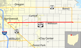
State Route 579 is an east–west state highway in northwestern Ohio, a U.S. state. The western terminus of SR 579 is at SR 51 just south of the city limits of Northwood. Its eastern terminus is at a T-intersection with SR 2 approximately four miles (6.4 km) to the east of Williston.

Ohio State Route 785 highway in Ohio

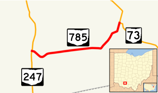
State Route 785 is a short east–west state highway in the southern portion of the U.S. state of Ohio. The western terminus of SR 785 is at SR 247 7.75 miles (12.47 km) north of Seaman in the community of Fairfax. Its eastern terminus is at its junction with SR 73 approximately nine miles (14 km) west of Sinking Spring in the community of Belfast.

Ohio State Route 678 highway in Ohio

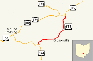
State Route 678 is a short four-mile-long (6.4 km) north–south state highway located in southeast Ohio. Entirely situated within Laurel Township in Hocking County, SR 678 has its southern terminus at SR 374 approximately one and a half miles (2.4 km) southwest of the hamlet of Gibisonville, and its northern terminus is at SR 180 nearly two and a half miles (4.0 km) northeast of Gibisonville. SR 678 provides a shorter alternative for traffic using SR 374 en route from Hocking Hills State Park up to U.S. Route 33 (US 33) at Rockbridge, in conjunction with SR 180.

Ohio State Route 761 highway in Ohio

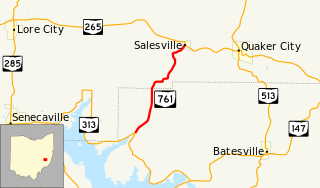
State Route 761 (SR 761) is a short state highway in the east-central portion of Ohio. The highway runs for 4.3 miles (6.9 km) from a T-intersection with SR 313 approximately four miles (6.4 km) southwest of Salesville to its junction with SR 265 in Salesville. This state route is also known as Kennonsburg Road for its entire length.

Ohio State Route 644 highway in Ohio

State Route 644 is a north–south state highway running through Columbiana and Carroll counties in northeast Ohio. Its southern terminus is at SR 39 in downtown Salineville, and its northern terminus is at its junction with U.S. Route 30(US 30) and SR 9 in the center of Kensington. The route connects mainly rural and a few unincorporated parts of southeastern Columbiana County. SR 644 only briefly passes into a corner of Carroll County for a 0.41-mile (0.66 km) journey.

Ohio State Route 691 highway in Ohio

Ohio State Route 691 is a north–south state route in southern Ohio. The entirety of SR 691 is within Athens County. Its southern terminus is at OH 56 about 1.5 miles (2.4 km) northwest of New Marshfield, and its northern terminus is at an interchange with US 33 and SR 78 in Nelsonville.

Ohio State Route 282 highway in Ohio

State Route 282 is a north–south state highway in northeastern Ohio, a U.S. state. The southern terminus of SR 282 is at a T-intersection with SR 305 near the hamlet of Nelson. Its northern terminus is also at a T-intersection, this time with the four-lane divided U.S. Route 422 (US 422) approximately two miles (3.2 km) southeast of Parkman. SR 282 primarily serves as an access route for Nelson Kennedy Ledges State Park. For its duration, the highway is also known as Nelson Ledge Road.

U.S. Route 24 in Ohio highway in Ohio

U.S. Route 24 (US 24) is a United States Numbered Highway that runs from Minturn, Colorado, to Independence Township, Michigan. In Ohio, it is an expressway and freeway for much of its length, from the Indiana state line to Maumee. From there northeasterly to the Michigan state line at Toledo, it is a surface highway.

U.S. Route 20 is a United States Numbered Highway that runs from Newport, Oregon to Boston, Massachusetts. Within the state of Ohio, the route runs from the Indiana border near Edon to the Pennsylvania border at Conneaut. The route passes through rural areas west of Toledo, and passes through Public Square in Cleveland. It is one of 9 other routes to enter downtown Cleveland at Public Square, and it serves some of Cleveland's northeastern suburbs.

Ohio State Route 215 highway in Ohio

State Route 215 is an east–west state highway in the southeastern portion of the U.S. state of Ohio. The western terminus of SR 215 is at a T-intersection with SR 821 just one-half mile (0.80 km) southeast of the village of Belle Valley and SR 821's junction with Interstate 77. Its eastern terminus is at another T-intersection, this time with SR 285 just outside the village of Sarahsville.

Ohio State Route 537 highway in Ohio

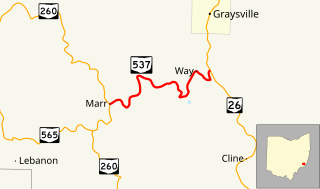
State Route 537 is a short east–west state highway in southeastern Ohio. At a length of just shy of five miles (8.0 km), SR 537 is located entirely within southwestern Monroe County. The state route's western terminus is at SR 260 approximately three and a half miles (5.6 km) southeast of the unincorporated community of Sycamore Valley, and its eastern terminus is at SR 26 one mile (1.6 km) south of the village limits of Graysville.

Ohio State Route 216 highway in Ohio

State Route 216 is a north–south state highway in the southeastern quadrant of the U.S. state of Ohio. The southern terminus of SR 216 is at a three-way stop T-intersection with SR 78 in Murray City. SR 216's northern terminus is also at a three-way stop T-intersection, this time with SR 93 in New Straitsville.

Ohio State Route 565 highway in Ohio

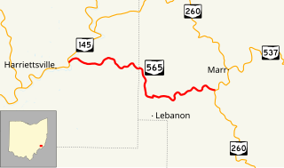
State Route 565 (SR 565) is a 6.98-mile-long (11.23 km) east–west state highway in the southeastern portion of the U.S. state of Ohio. The western terminus of SR 565 is at a T-intersection with SR 145 nearly 8 miles (13 km) northeast of the village of Lower Salem. Its eastern terminus is also at a T-intersection, this time at SR 260 approximately 7.25 miles (11.67 km) southwest of Graysville.

References

Route map: Google

KML file (edithelp)
KML is from Wikidata
  1. 1 2 "DESTAPE - Athens County" (PDF). Ohio Department of Transportation. June 24, 2015. Retrieved November 17, 2015.
  2. National Highway System: Ohio (PDF) (Map). Federal Highway Administration. December 2003. Retrieved 2010-07-23.
  3. Google (2010-07-23). "Overview Map of State Route 685" (Map). Google Maps . Google. Retrieved 2010-07-23.
  4. Ohio State Map (Map). Ohio Department of Transportation. 1936.
  5. Ohio State Map (Map). Ohio Department of Transportation. 1937.
  6. Ohio State Map (Map). Ohio Department of Transportation. 1961.
  7. Ohio State Map (Map). Ohio Department of Transportation. 1962.