State Route 247 (SR 247) is a 30.49-mile (49.07 km) long north–south state highway in the southern part of the U.S. state of Ohio. SR 247 has its southern terminus at a dead end overlooking the Ohio River 0.35 miles (0.56 km) south of its junction with U.S. Route 52 (US 52), nearly 4.75 miles (7.64 km) northeast of Manchester. The northern terminus of SR 247 is at a signalized intersection with State Route 73 in Hillsboro.

State Route 770 is a north–south state highway in the southern portion of the U.S. state of Ohio. The southern terminus of State Route 770 is at State Route 247 in Seaman. Its northern terminus is at its junction with State Route 73 about 10.5 miles (16.9 km) north of Seaman, just inside of the Adams-Highland County Line.

State Route 511 (SR 511) is a 50.27-mile-long (80.90 km) north–south state highway in the northern portion of the U.S. state of Ohio. The southern terminus of SR 511 is at a T-intersection with SR 39 about 2 miles (3.2 km) north of Perrysville. Its northern terminus is at a trumpet interchange with the U.S. Route 20 (US 20) freeway 0.75 miles (1.21 km) east of Oberlin.

State Route 595 is a north–south state highway in southeastern Ohio, a U.S. state. The route's southern terminus is at a diamond interchange with the U.S. Route 33 (US 33) expressway approximately three and a half miles (5.6 km) southeast of Logan. Its northern terminus is at a T-intersection with SR 216 in New Straitsville, just two blocks southeast of SR 216's northern terminus at SR 93.
State Route 266 (SR 266) is a 14-mile-long (23 km) east–west state highway located in the southeastern portion of Ohio. SR 266's western terminus is at an intersection with SR 377 nearly 3 1⁄2 miles (5.6 km) northwest of Stockport, and its eastern terminus is an intersection with SR 60 approximately 4 1⁄2 miles (7.2 km) northwest of Beverly.

State Route 566 is a north–south state highway in eastern Ohio, a U.S. state. Located exclusively in northern Noble County, SR 566 has its southern terminus at SR 147, at a T-intersection 1.25 miles (2.01 km) north of the unincorporated community of Mount Ephraim. Its northern terminus is at another T-intersection, this time with SR 285 approximately 1.25 miles (2.01 km) south of the village of Senecaville.

State Route 325 is a north–south state highway in the southeastern corner of the U.S. state of Ohio. The southern terminus of SR 325 is at SR 141 about 6 miles (9.7 km) south of Rio Grande. Its northern terminus is at a T-intersection with SR 124 approximately 5 miles (8.0 km) west of the village of Rutland.

State Route 339 (SR 339) is a north–south state highway in southeastern Ohio, a U.S. state. The southern terminus of SR 339 is at SR 618 approximately 2 miles (3.2 km) west of Belpre, and less than 0.50 miles (0.80 km) south of the U.S. Route 50 (US 50)/SR 7/SR 32 expressway. The highway's northern terminus is a T-intersection with SR 821 about 0.75 miles (1.21 km) south of Dexter City.

State Route 726 is a north–south state highway in western Ohio, a U.S. state. The southern terminus of the state route is at a T-intersection with US 127 about 1 mile (1.6 km) north of the city limits of Eaton. The northern terminus of SR 726 is at a signalized intersection with SR 121 in downtown New Madison.
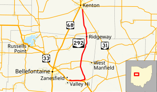
State Route 292 is a two-lane north–south state highway in the western portion of the U.S. state of Ohio. The southern terminus of the highway is at a diamond interchange with the U.S. Route 33 (US 33) expressway approximately one mile (1.6 km) southeast of the village of Zanesfield. Its northern terminus is at a Y-intersection with SR 31 just south of the city limits of Kenton.

State Route 278 is a north–south state highway located in the southeastern part of the U.S. state of Ohio. The southern terminus of SR 278 is at US 50 approximately 4.75 miles (7.64 km) east of McArthur. The highway's northern terminus is at the T-intersection it has with SR 595 nearly 5.50 miles (8.85 km) northwest of Nelsonville.

State Route 282 is a north–south state highway in northeastern Ohio, a U.S. state. The southern terminus of SR 282 is at a T-intersection with SR 305 near the hamlet of Nelson. Its northern terminus is also at a T-intersection, this time with the four-lane divided U.S. Route 422 (US 422) approximately two miles (3.2 km) southeast of Parkman. SR 282 primarily serves as an access route for Nelson Kennedy Ledges State Park. For its duration, the highway is also known as Nelson Ledge Road.
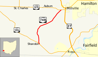
State Route 748 is a north–south state highway in southwestern Ohio, a U.S. state. Situated in west-central Butler County, SR 748 has its southern terminus at SR 126 in the unincorporated community of Shandon. Its northern terminus is at SR 129 near Millville, just one-half mile (0.80 km) west of SR 129's junction with U.S. Route 27.
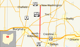
State Route 602 (SR 602) is a 14.47-mile-long (23.29 km) north–south state highway in the northern portion of the U.S. state of Ohio. Its southern terminus is at a T-intersection with SR 19 approximately 2.50 miles (4.02 km) northwest of Galion, and its northern terminus is at SR 103 in New Washington.
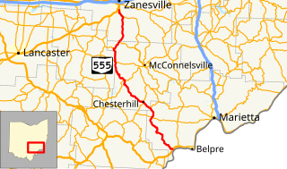
State Route 555 is a 62.36-mile-long (100.36 km), north–south running state highway that passes through four counties in southeastern Ohio. State Route 555's southern terminus is at the concurrency of US 50, SR 7 and SR 32 in the unincorporated community of Little Hocking in extreme southwestern Washington County. Its northern terminus is at SR 60 in Wayne Township, just outside Zanesville. The route passes through primarily rural portions of Washington, Morgan, Perry, and Muskingum counties, connecting unincorporated villages along the way. Its emergence into southern Zanesville at the route's northern end takes the route into a more suburban setting before it terminates.
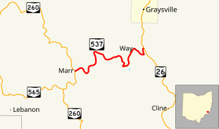
State Route 537 is a short east–west state highway in southeastern Ohio. At a length of just shy of five miles (8.0 km), SR 537 is located entirely within southwestern Monroe County. The state route's western terminus is at SR 260 approximately three and a half miles (5.6 km) southeast of the unincorporated community of Sycamore Valley, and its eastern terminus is at SR 26 one mile (1.6 km) south of the village limits of Graysville.

State Route 743 is a short east–west state highway in southwestern Ohio, a U.S. state. The highway's western terminus is in the village of Moscow at the intersection of Wells Street and 5th Street, a mere two blocks off of U.S. Route 52 (US 52). Traversing Clermont County's Moscow and Washington Township, SR 743 ultimately arrives at its eastern terminus at SR 222 approximately four and a half miles (7.2 km) northwest of Felicity.
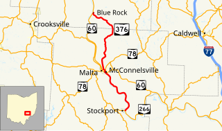
State Route 376 is a north–south state highway in the southeastern portion of the U.S. state of Ohio. SR 376 has its southern terminus at a T-intersection with SR 266 just across the Muskingum River from Stockport. Its northern terminus is at SR 60 in the unincorporated community of Blue Rock.

State Route 145 is a 46.14-mile (74.26 km) long north–south state highway in the southeastern quadrant of the U.S. state of Ohio. The western terminus of SR 145 is at a T-intersection with SR 821 in Lower Salem. Its eastern terminus is at a T-intersection with SR 148 approximately 5.25 miles (8.45 km) northeast of Beallsville.