Ohio State Route 799

Last updated

OH-799.svg

State Route 799
OH 799 map.svg
Route information
Maintained by ODOT
Length 6.05 mi [1] (9.74 km)
Existed 1949 [2] [3] – present
Major junctions
West endOH-800.svg SR 800 near Freeport
East endCR 21 jct (OH).svg CR 21 near Deersville
Location
Counties Harrison
Highway system
OH-798.svg SR 798 SR 800 OH-800.svg

State Route 799 (SR 799) is an eastwest state highway located in the eastern portion of the U.S. state of Ohio. The highway runs from its western terminus at a T-intersection with SR 800 approximately 1.25 miles (2.01 km) northeast of Freeport to its eastern terminus at its intersection with Redeye Road (County Road 60 or CR 60) about three miles (4.8 km) south of Deersville. Continuing north from SR 799's eastern terminus is Mallarnee Road (CR 21).

A state highway, state road, or state route is usually a road that is either numbered or maintained by a sub-national state or province. A road numbered by a state or province falls below numbered national highways in the hierarchy. Roads maintained by a state or province include both nationally numbered highways and un-numbered state highways. Depending on the state, "state highway" may be used for one meaning and "state road" or "state route" for the other.

U.S. state constituent political entity of the United States

In the United States, a state is a constituent political entity, of which there are currently 50. Bound together in a political union, each state holds governmental jurisdiction over a separate and defined geographic territory and shares its sovereignty with the federal government. Due to this shared sovereignty, Americans are citizens both of the federal republic and of the state in which they reside. State citizenship and residency are flexible, and no government approval is required to move between states, except for persons restricted by certain types of court orders. Four states use the term commonwealth rather than state in their full official names.

Ohio State of the United States of America

Ohio is a Midwestern state in the Great Lakes region of the United States. Of the fifty states, it is the 34th largest by area, the seventh most populous, and the tenth most densely populated. The state's capital and largest city is Columbus.

Contents

SR 799 was created in the late 1940s. This two-lane spur route was established to improve access to the Clendening Lake region. In addition, it provides an improved route from SR 800 to the village of Deersville. SR 799 is designated as a part of the Tappan-Moravian Trail Scenic Byway. [4]

Spur route

A spur route is a short road forming a branch from a longer, more important road such as a freeway, Interstate Highway, or motorway. A bypass or beltway should not be considered a true spur route as it typically reconnects with another or the same major road.

Clendening Lake

Clendening Lake is a reservoir located in Harrison County, Ohio, in the United States, formed by damming Brushy Fork, 0.5 miles (0.80 km) East of Tippecanoe.

Village Small clustered human settlement smaller than a town

A village is a clustered human settlement or community, larger than a hamlet but smaller than a town, with a population ranging from a few hundred to a few thousand. Though villages are often located in rural areas, the term urban village is also applied to certain urban neighborhoods. Villages are normally permanent, with fixed dwellings; however, transient villages can occur. Further, the dwellings of a village are fairly close to one another, not scattered broadly over the landscape, as a dispersed settlement.

Route description

Clendening Lake from SR 799 Clendening Lake.JPG
Clendening Lake from SR 799

This state highway exists entirely within the western part of Harrison County. SR 799 is not a part of the National Highway System. [5]

Harrison County, Ohio County in the United States

Harrison County is a county located in the U.S. state of Ohio. As of the 2010 census, the population was 15,864, making it the fifth-least populous county in Ohio. Its county seat is Cadiz. The county is named for General William Henry Harrison, who was later President of the United States.

National Highway System (United States) highway system in the United States

The National Highway System (NHS) is a network of strategic highways within the United States, including the Interstate Highway System and other roads serving major airports, ports, rail or truck terminals, railway stations, pipeline terminals and other strategic transport facilities. Altogether, it constitutes the largest highway system in the world.

SR 799 begins at a T-intersection with SR 800 in Washington Township 1.25 miles (2.01 km) northeast of Freeport. From this point, passing first amidst some open fields before entering into a more forested terrain, with the occasional house appearing along the way, SR 799 roughly parallels the Clendening Lake shoreline about one-quarter mile (0.40 km) to the south, in the process entering Nottingham Township, dipping briefly into Moorefield Township before turning north, re-entering Nottingham Township, and then following Clendening Lake's eastern edge. SR 799 crosses small bays formed by the lake twice, and comes to an end at its intersection with CR 60 (Redeye Road) just past the lake's northernmost extent. The road continues another three miles (4.8 km) north to Deersville as CR 21 (Mallarnee Road). [6]

Washington Township, Harrison County, Ohio Township in Ohio, United States

Washington Township is one of the fifteen townships of Harrison County, Ohio, United States. As of the 2010 census the population was 638.

Nottingham Township, Harrison County, Ohio Township in Ohio, United States

Nottingham Township is one of the fifteen townships of Harrison County, Ohio, United States. As of the 2010 census the population was 324, down from 392 at the 2000 census.

Moorefield Township, Harrison County, Ohio Township in Ohio, United States

Moorefield Township is one of the fifteen townships of Harrison County, Ohio, United States. As of the 2010 census the population was 403.

History

SR 799 was designated in 1949. The highway has been a spur route since its inception, following the same alignment through the Clendening Lake vicinity from that point to this very day. It has not experienced any major changes to its routing since it was established. [2] [3]

Major intersections

The entire route is in Harrison County.

Locationmi [1] kmDestinationsNotes
Washington Township 0.000.00OH-800.svg SR 800  Freeport, Dennison
Nottingham Township 6.059.74CR 21 jct (OH).svgCR 60 jct (OH).svg CR 21 (Mallarnee Road) / CR 60 (Redeye Road)
1.000 mi = 1.609 km; 1.000 km = 0.621 mi

Related Research Articles

Ohio State Route 330 highway in Ohio

State Route 330 is a north–south state highway in the northwestern portion of the U.S. state of Ohio. The southern terminus of SR 330 is at a diamond interchange with the SR 15 expressway just south of the village limits of Vanlue. Its northern terminus is at SR 568 nearly 1.75 miles (2.82 km) north of Vanlue.

Ohio State Route 300 highway in Ohio

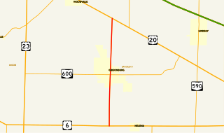
State Route 300 is a 6.33-mile (10.19 km) long north–south state highway in northwestern Ohio, a U.S. state. The southern terminus of SR 300 is at a T-intersection with U.S. Route 6 (US 6) approximately 1.50 miles (2.41 km) west of the village of Helena. Its northern terminus is at US 20 just over 2.50 miles (4.02 km) southeast of Woodville.

Ohio State Route 368 highway in Ohio

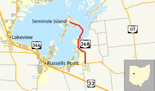
State Route 368 is a short north–south state highway in western Ohio, a U.S. state. SR 368 travels from its southern terminus at SR 366 approximately 1.75 miles (2.82 km) east of Russells Point to its northern terminus on Seminole Island in the eastern half of Indian Lake, at an intersection where it meets Logan County Road 272 (CR 272) and CR 286. Having made its debut in the late 1930s, SR 368 is a two-lane spur route that serves both Indian Lake State Park and communities of cottages that are on two eastern Indian Lake islands: Shawnee and Seminole.

Ohio State Route 287 highway in Ohio

State Route 287 (SR 287) is a 13.69-mile-long (22.03 km) east–west state highway in the western portion of the U.S. state of Ohio. The western terminus of SR 287 is at SR 245 nearly 1.75 miles (2.82 km) east of West Liberty. Its eastern terminus is at an interchange with U.S. Route 33 (US 33) about 5.25 miles (8.45 km) northeast of North Lewisburg that dually serves as the southern terminus of SR 739.

Ohio State Route 161 highway in Ohio

State Route 161 (SR 161) is an east–west state highway in central Ohio. Its western terminus is in Mutual at State Route 29 and its eastern terminus is near Alexandria at State Route 37. It is 57.46 miles (92.47 km) long. State Route 161 passes through Columbus, Ohio's capital, and a variety of towns including Plain City, Dublin, and New Albany.

Ohio State Route 220 highway in Ohio

State Route 220 is an east–west state highway in the south central portion of the U.S. state of Ohio. Its western terminus is at SR 772 about 8.25 miles (13.28 km) west of Waverly, and its eastern terminus is at the SR 32/SR 124 concurrency 3 miles (4.8 km) east of Piketon. The entire route is in Pike County.

Ohio State Route 609 highway in Ohio

State Route 609 (SR 609) is a 2.65-mile (4.26 km) long east–west state highway in the northeastern portion of the U.S. state of Ohio. The highway runs from its western terminus at a T-intersection SR 7 approximately 2 miles (3.2 km) west of the village of Orangeville to its eastern terminus at the Pennsylvania State line in Orangeville, where SR 609 meets a county-maintained road that straddles the border, Brockway–Sharon Road, at a T-intersection.

Ohio State Route 621 highway in Ohio

State Route 621 is a north–south state highway in the central part of the U.S. state of Ohio. The southern terminus of SR 621 is at U.S. Route 36 approximately two and a half miles (4.0 km) northeast of Coshocton, and its northern terminus is adjacent to the North Appalachian Experimental Watershed Station, just north of its intersection with White Eyes Township Road 188, about 5 miles (8.0 km) northwest of the hamlet of Fresno. Continuing north after SR 621 ends is County Road 190.

Ohio State Route 500 highway in Ohio

State Route 500 (SR 500) is a 13.32-mile-long (21.44 km) Ohio State Route that runs between the Indiana state line and Paulding in the US state of Ohio. None of the highway is listed on the National Highway System. Most of the route is a rural two-lane highway and passes through both farmland and residential properties. For much of its path, SR 500 runs generally parallel to the north of Flatrock Creek.

Ohio State Route 383 highway in Ohio

State Route 383 (SR 383) is a 1.50-mile-long (2.41 km) north south state highway in the central portion of the U.S. state of Ohio. The highway is a spur route whose southern terminus is at the entrance to Ohio's oldest Catholic Church, Saint Joseph's, nearly two miles (3.2 km) southeast of Somerset. County Road 60 picks up where SR 383 leaves off heading southeast from the church entrance. The northern terminus of SR 383 is at a T-intersection with SR 13 just 0.50 miles (0.80 km) east of the village limits of Somerset.

Ohio State Route 288 highway in Ohio

State Route 288 (SR 288) is a 6.82-mile (10.98 km) long east–west state highway in the northern portion of the U.S. state of Ohio. The western terminus of SR 288 is at a T-intersection with SR 309 about 3 miles (4.8 km) southwest of Galion. Its eastern terminus is also at a T-intersection, this time with SR 97 approximately 5.50 miles (8.85 km) northwest of Lexington.

Ohio State Route 185 highway in Ohio

State Route 185 (SR 185) is a 21.70-mile (34.92 km) long east–west state highway in the western part of the U.S. state of Ohio. The western terminus of SR 185 is at U.S. Route 127 (US 127) approximately 3.75 miles (6.04 km) south of North Star. Its eastern terminus is in Piqua. Until 2011, this was at its junction with US 36 and SR 66 in the city's downtown business district, at the intersection of Ash Street and Spring Street. In 2011, SR 185 was re-routed to travel south along Sunset Drive in the western part of Piqua to a new eastern terminus where Sunset Drive meets US 36, which is known as Covington Avenue at that location.

Ohio State Route 320 highway in Ohio

State Route 320 (SR 320) is a short north–south state highway in western Ohio, a U.S. state. The southern terminus of SR 320 is at U.S. Route 35 (US 35) approximately three miles (4.8 km) southeast of New Paris, 34 mile (1.2 km) south of US 35's eastern junction with Interstate 70 (I-70). The northern terminus of the state highway is located in New Paris at a signalized intersection with SR 121.

Ohio State Route 557 highway in Ohio

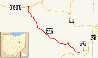
State Route 557 is a two-lane north–south state highway in the central portion of Ohio, a U.S. state. The highway's southern terminus is at a T-intersection with State Route 643 approximately 2 miles (3.2 km) north of Baltic. Its northern terminus is at a T-intersection with the concurrency of U.S. Route 62 and State Route 39 nearly 1.5 miles (2.4 km) west of the unincorporated community of Berlin.

Ohio State Route 565 highway in Ohio

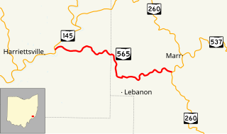
State Route 565 (SR 565) is a 6.98-mile-long (11.23 km) east–west state highway in the southeastern portion of the U.S. state of Ohio. The western terminus of SR 565 is at a T-intersection with SR 145 nearly 8 miles (13 km) northeast of the village of Lower Salem. Its eastern terminus is also at a T-intersection, this time at SR 260 approximately 7.25 miles (11.67 km) southwest of Graysville.

Ohio State Route 643 highway in Ohio

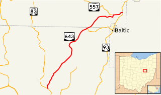
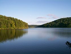
State Route 643 is a two-lane north–south state highway in the central portion of Ohio, a U.S. state. The highway's southern terminus is at a T-intersection with State Route 83 north of Coshocton. Its northern terminus is at a T-intersection with the concurrency of State Route 93 north of Baltic. A section of the route is part of a scenic byway.

Ohio State Route 646

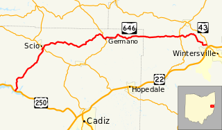
State Route 646 is a 28.78-mile-long (46.32 km) state highway in Harrison and Jefferson Counties in eastern Ohio. The route runs from US 250 in Stock Township, northwest of Cadiz, to SR 43 in Island Creek Township, just outside Wintersville.

References

  1. 1 2 "DESTAPE - Harrison County" (PDF). Ohio Department of Transportation. June 24, 2015. Retrieved November 6, 2015.
  2. 1 2 Ohio Highway Map (MrSID) (Map). Cartography by ODOH. Ohio Department of Highways. 1948. Retrieved 2011-01-16.
  3. 1 2 Ohio Highway Map (MrSID) (Map). Cartography by ODOH. Ohio Department of Highways. 1949. Retrieved 2011-01-16.
  4. "Tappan-Moravian Trail Scenic Byway". Ohio Department of Transportation . Retrieved 2008-10-09.
  5. National Highway System: Ohio (PDF) (Map). Federal Highway Administration. December 2003. Retrieved 2011-01-16.
  6. Google (November 6, 2015). "Ohio State Route 799" (Map). Google Maps . Google. Retrieved November 6, 2015.

Route map: Google

KML file (edithelp)
KML is from Wikidata