Ohiopyle Low Bridge

Last updated
Ohiopyle Low Bridge
Ohiopylelow.jpg
Coordinates 39°52′N79°29′W / 39.87°N 79.49°W / 39.87; -79.49
Carries Great Allegheny Passage trail
Crosses Youghiogheny River
Locale Ohiopyle, Pennsylvania
Characteristics
Design bowstring truss bridge
Total length620 feet (190 m)
History
Opened1912, 1999
Location
Ohiopyle Low Bridge

The Ohiopyle Low Bridge is an American structure that carries the Great Allegheny Passage trail across the Youghiogheny River in Ohiopyle, Pennsylvania. [1]

Contents

History and architectural features

The span was originally opened in 1912 as part of the last major railroad built in Pennsylvania. It served the Western Maryland Railway's expansion from Cumberland, Maryland to Connellsville, Pennsylvania and was one of two bridges to cross a meandering section of the Youghiogheny River in Ohiopyle. The original deck girder bridge was located near the center of the tiny community of Ohiopyle and opened the rugged region to tourism.

By the 1960s, the importance of the Low Bridge had been dramatically reduced. The automobile had replaced the train as the method of transportation to what was now Ohiopyle State Park, and the narrow clearance of Pennsylvania Route 381's passage under the bridge would lead to bottlenecks during the summer tourism season.

The Western Maryland Railway was incorporated into the Chessie System holding company and saw traffic greatly reduced on ancillary lines; in 1975, all service west of Hancock, Maryland was eliminated.

Following the closure of the line, a portion of the old bridge was removed to allow for better truck access along PA 381, while the remainder of the structure sat vacant until its incorporation into the Great Allegheny Passage.

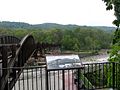
In 1999, a new bowstring truss bridge was opened on the existing piers of its predecessor. The new bridge is the longest of its type in Pennsylvania.

Related Research Articles

<span class="mw-page-title-main">Garrett County, Maryland</span> County in Maryland, United States

Garrett County is the westernmost county of the U.S. state of Maryland. As of the 2020 census, the population was 28,806, making it the third-least populous county in Maryland. Its county seat is Oakland. The county was named for John Work Garrett (1820–1884), president of the Baltimore and Ohio Railroad. Created from Allegany County, Maryland in 1872, it was the last Maryland county to be formed.

<span class="mw-page-title-main">Connellsville, Pennsylvania</span> City in Pennsylvania, United States

Connellsville is a city in Fayette County, Pennsylvania, United States, 36 miles (58 km) southeast of Pittsburgh and 50 miles (80 km) away via the Youghiogheny River, a tributary of the Monongahela River. It is part of the Pittsburgh Metro Area. The population was 7,637 at the 2010 census, a decline from the figure of 9,146 tabulated in 2000.

<span class="mw-page-title-main">Ohiopyle, Pennsylvania</span> Borough in Pennsylvania, United States

Ohiopyle is a borough in Fayette County, Pennsylvania, United States. The population was 38 at the 2020 census. While Ohiopyle has a tiny year-round population, it is often filled with tourists on the weekend, who come for the outdoor recreation opportunities at the surrounding Ohiopyle State Park, as well as the Great Allegheny Passage bicycle trail which connects with the Chesapeake and Ohio Canal towpath trail to form a continuous 335-mile off-road trail from Pittsburgh, Pennsylvania to Washington, D.C. The borough of Ohiopyle is served by the Uniontown Area School District.

<span class="mw-page-title-main">Stewart Township, Fayette County, Pennsylvania</span> Township in Pennsylvania, United States

Stewart Township is a township in Fayette County, Pennsylvania, United States. It is part of the Pittsburgh Metro Area. The population was 619 at the 2020 census.

<span class="mw-page-title-main">Smithton, Pennsylvania</span> Borough in Pennsylvania, United States

Smithton is a borough in Westmoreland County, Pennsylvania, United States. The population was 399 at the 2010 census. As of 2018, the population was listed at 378. Smithton has its own post office, with zip code 15479, and is serviced by Yough School District.

<span class="mw-page-title-main">Youghiogheny River</span> River in Pennsylvania, West Virginia and Maryland, U.S.

The Youghiogheny River, or the Yough for short, is a 134-mile-long (216 km) tributary of the Monongahela River in the U.S. states of West Virginia, Maryland, and Pennsylvania. It drains an area on the west side of the Allegheny Mountains northward into Pennsylvania, providing a small watershed in extreme western Maryland into the tributaries of the Mississippi River. Youghiogheny is a Lenape word meaning "a stream flowing in a contrary direction".

<span class="mw-page-title-main">Great Allegheny Passage</span> Rail trail connecting Cumberland, Maryland and Pittsburgh, Pennsylvania

The Great Allegheny Passage (GAP) is a 150-mile (240 km) rail trail between Pittsburgh, Pennsylvania and Cumberland, Maryland. Together with the C&O Canal towpath, the GAP is part of a 335 mi (539 km) route between Pittsburgh and Washington, D.C., that is popular with through hikers and cyclists.

<span class="mw-page-title-main">Laurel Highlands</span> Region in Pennsylvania

The Laurel Highlands is a region in southwestern Pennsylvania made up of Fayette County, Somerset County, and Westmoreland County. It has a population of about 600,000 people.

<span class="mw-page-title-main">Bear Run</span> Stream in Pennsylvania, USA

Bear Run is a 5.0-mile-long (8.0 km) tributary of the Youghiogheny River in Fayette County, Pennsylvania, in the United States.

<span class="mw-page-title-main">Western Maryland Scenic Railroad</span> Heritage railroad based in Cumberland, Maryland, United States

The Western Maryland Scenic Railroad (WMSR) is a heritage railroad based in Cumberland, Maryland, that operates passenger excursion trains and occasional freight trains using both steam and diesel locomotives over ex-Western Maryland Railway (WM) tracks between Cumberland and Frostburg. The railroad offers coach and first class service, murder mystery excursions, and special seasonal trips.

<span class="mw-page-title-main">Ohiopyle State Park</span>

Ohiopyle State Park is a Pennsylvania state park on 20,500 acres (8,300 ha) in Dunbar, Henry Clay and Stewart Townships, Fayette County, Pennsylvania in the United States. The focal point of the park is the more than 14 miles (23 km) of the Youghiogheny River Gorge that passes through the park. The river provides some of the best whitewater boating in the Eastern United States. Ohiopyle State Park is bisected by Pennsylvania Route 381 south of the Pennsylvania Turnpike. The park opened to the public in 1965 but was not officially dedicated until 1971.

<span class="mw-page-title-main">Casselman River</span> Stream in Pennsylvania, USA

The Casselman River is a 56.5-mile-long (90.9 km) tributary of the Youghiogheny River in western Maryland and Pennsylvania in the United States. The Casselman River drains an area of 576 square miles.

<span class="mw-page-title-main">Laurel Hill (Pennsylvania)</span> Mountain in Pennsylvania, United States

Laurel Hill, also known as Laurel Ridge or Laurel Mountain, is a 70-mile-long (110 km) mountain that is located in Pennsylvania's Allegheny Mountains. This ridge is flanked by Negro Mountain to its east and Chestnut Ridge to its west. The mountain is home to six state parks: Laurel Ridge State Park, Laurel Mountain State Park, Linn Run State Park, Kooser State Park, Laurel Hill State Park, and Ohiopyle State Park. The 70-mile-long (110 km) Laurel Highlands Hiking Trail runs the length of the ridge.

The Memorial Bridge is a structure that crosses the Youghiogheny River, connecting the eastern and western shores of Connellsville, Pennsylvania, USA.

The Fifteenth Street Bridge is a girder bridge across the Youghiogheny River connecting the Pittsburgh industrial suburbs of Port Vue and McKeesport, Pennsylvania. The 1995 structure replaced a 1906 truss bridge. The bridge's length is significantly longer than that of several surrounding structures because its crosses both the river and a large water treatment facility.

The Sutersville Bridge is a structure that crosses the Youghiogheny River between Sutersville and Elizabeth Township, Pennsylvania. It connects a rural southeastern corner of Allegheny County with a small Westmoreland County town.

The Ohiopyle High Bridge is a structure that carries the Great Allegheny Passage trail across the Youghiogheny River in Ohiopyle, Pennsylvania.

<span class="mw-page-title-main">Ohiopyle Highway Bridge</span> Bridge in Ohiopyle, Pennsylvania

The Ohiopyle Highway Bridge is a structure that carries two lanes of Pennsylvania Route 381 Youghiogheny River in Ohiopyle, Pennsylvania

<span class="mw-page-title-main">Blair Gap</span>

Blair Gap, one of the gaps of the Allegheny, is a water gap along the eastern face atop the Allegheny Front escarpment. Like other gaps of the Allegheny, the slopes of Blair Gap were amenable to foot travel, pack mules, and possibly wagons allowing Amerindians, and then, after about 1778-1780 settlers, to travel west into the relatively depopulated Ohio Country decades before the railroads were born and tied the country together with steel.

<span class="mw-page-title-main">Gaps of the Allegheny</span>

The gaps of the Allegheny, meaning gaps in the Allegheny Ridge in west-central Pennsylvania, is a series of escarpment eroding water gaps along the saddle between two higher barrier ridge-lines in the eastern face atop the Allegheny Ridge or Allegheny Front escarpment. The front extends south through Western Maryland and forms much of the border between Virginia and West Virginia, in part explaining the difference in cultures between those two post-Civil War states. While not totally impenetrable to daring and energetic travelers on foot, passing the front outside of the water gaps with even sure footed mules was nearly impossible without navigating terrain where climbing was necessary on slopes even burros would find extremely difficult.

References

  1. "Ohiopyle Low Bridge on the Great Allegheny Passage" . Retrieved 11 November 2014.

Coordinates: 39°52′14″N79°29′37″W / 39.87060°N 79.49368°W / 39.87060; -79.49368