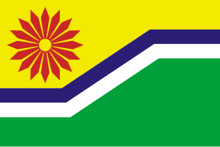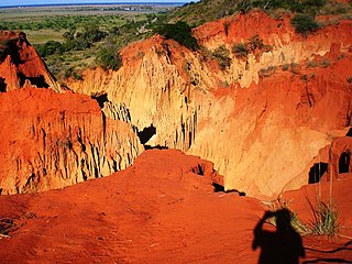
Mpumalanga is one of the nine provinces of South Africa. The name means "East", or literally "The Place Where the Sun Rises" in the Nguni languages. Mpumalanga lies in eastern South Africa, bordering Eswatini and Mozambique. It shares borders with the South African provinces of Limpopo to the north, Gauteng to the west, the Free State to the southwest, and KwaZulu-Natal to the south. The capital is Mbombela.

Maputo Province is a province of Mozambique; the province excludes the city of Maputo. The province has an area of 22,693 km2 (8,762 sq mi) and a population of 1,968,906. Its capital is the city of Matola.

The Highveld is the portion of the South African inland plateau which has an altitude above roughly 1,500 m (4,900 ft), but below 2,100 m (6,900 ft), thus excluding the Lesotho mountain regions to the south-east of the Highveld. It is home to some of the country's most important commercial farming areas, as well as its largest concentration of metropolitan centres, especially the Gauteng conurbation, which accommodates one-third of South Africa's population.

The Olifants River,Lepelle, iBhalule or Obalule is a river in South Africa and Mozambique, a tributary of the Limpopo River. It falls into the Drainage Area B of the Drainage basins of South Africa. The historical area of the Pedi people, Sekhukhuneland, is located between the Olifants River and one of its largest tributaries, the Steelpoort River.

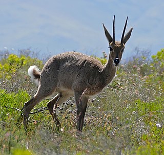
The grey rhebok, locally known as the vaalribbok in Afrikaans, is a species of antelope native to South Africa, Lesotho, and Eswatini (Swaziland). The specific name capreolus is Latin for 'little goat'.

The R36 is a provincial route in South Africa that connects the N1 at Bandelierkop with Ermelo, via Tzaneen and Lydenburg. It is co-signed with the N4 for 8 kilometres between Machadodorp and Patattanek, with a tollgate on this section. It used to extend further south past Ermelo to Amersfoort, but that section is now designated as part of the N11.
The Treur River barb or simply Treur barb is a species of cyprinid fish. It is endemic to northern Mpumalanga, South Africa.

Protea comptonii, also known as saddleback sugarbush, is a smallish tree of the genus Protea in the family Proteaceae. It is found in South Africa and Eswatini.

Protea laetans, the Blyde River protea or Blyde sugarbush, is a species of flowering plant in the family Proteaceae. It was recognised as a species in 1970, and is endemic to the Blyde River Canyon of the Mpumalanga escarpment, South Africa. The slender plants are up to 5m tall and flower from mid to late summer. The bracts of their closed flower heads are shiny and silvery in appearance. They are most easily viewed near the F.H. Odendaal camp of the Blyde River Canyon Nature Reserve. Laetans means joyous, i.e. Blyde.

South African National Parks (SANParks) is the body responsible for managing South Africa's national parks. SANParks was formed in 1926, and currently manages 19 parks consisting of 3,751,113 hectares (37,511.13 km2), over 3% of the total area of South Africa.
The Mpumalanga Tourism and Parks Agency (MTPA) Board is a governmental organisation responsible for maintaining wilderness areas and public nature reserves in Mpumalanga Province, South Africa.
Blyde River Canyon Nature Reserve is situated in the Drakensberg escarpment region of eastern Mpumalanga, South Africa. The reserve protects the Blyde River Canyon, including sections of the Ohrigstad and Blyde Rivers and the geological formations around Bourke's Luck Potholes, where the Treur River tumbles into the Blyde below. Southwards of the canyon, the reserve follows the escarpment, to include the Devil's and God's Window, the latter a popular viewpoint to the lowveld at the reserve's southern extremity.
Mkhombo Nature Reserve is a protected area in Mpumalanga, South Africa. It is a large, 11,223 ha reserve which conserves an easterly Kalahari thornveld environment around the shores of a Mkhombo dam. The reserve has typical Highlands grassland with a network of wetlands and rocky outcrops.

Blyderivierpoort Dam is a gravity-arch dam on the Blyde River, in the lower Blyde River Canyon, near Hoedspruit in Mpumalanga, South Africa. It also floods the lower reaches of the Blyde's Ohrigstad River tributary. The dam was completed in 1974. The 71 m high dam wall and 22 m deep is situated 3 km from Swadini resort by road.
Ohrigstad Dam is a rockfill type dam located close to Ohrigstad in Mpumalanga, South Africa. It was established in 1955 and serves primarily for irrigation purposes. The hazard potential of the dam has been ranked high (3).

The Motlatse River, Blyde River, or Umdhlazi River is a river in the Mpumalanga and Limpopo provinces of South Africa. It has a northwards course in steep-sided valleys and ravines of the Mpumalanga Drakensberg, before it enters the lowveld region of the Limpopo province. It has its ultimate origins at around 2,000 m altitude in the Hartebeesvlakte conservation area, to the north of Long Tom Pass. It runs through the Blyde River Canyon.
Ohrigstad River is located in Mpumalanga, South Africa. The Ohrigstad River joins the Blyde River at the Blyderivierpoort Dam in the Blyde River Canyon Nature Reserve. Like the Blyde, it has its ultimate origin at around 2,000 m altitude to the south, on the verge of the Hartebeesvlakte conservation area, but follows a more westerly course.
The R532 is a Regional Route in South Africa that connects the Blyde River Canyon with Sabie via Graskop.
Voortrekker Fort/Ohrigstad Fort was constructed before 1847 to act as a refuge for local Voortrekker families due to the constant attacks of local Bantu tribes. It is situated in the Ohrigstad area of northern Mpumalanga province which was first settled by Europeans under the leadership of Andries Hendrik Potgieter.


