The protected areas of South Africa include national parks and marine protected areas managed by the national government, public nature reserves managed by provincial and local governments, and private nature reserves managed by private landowners. Most protected areas are intended for the conservation of flora and fauna. National parks are maintained by South African National Parks (SANParks). A number of national parks have been incorporated in transfrontier conservation areas.

Andries Hendrik Potgieter, known as Hendrik Potgieter was a Voortrekker leader and the last known Champion of the Potgieter family. He served as the first head of state of Potchefstroom from 1840 and 1845 and also as the first head of state of Zoutpansberg from 1845 to 1852.

The Olifants River, Lepelle or Obalule is a river in South Africa and Mozambique, a tributary of the Limpopo River. It falls into the Drainage Area B of the Drainage basins of South Africa. The historical area of the Pedi people, Sekhukhuneland, is located between the Olifants River and one of its largest tributaries, the Steelpoort River.
The Treur River barb or simply Treur barb is a species of cyprinid fish. It is endemic to northern Mpumalanga, South Africa.

Protea laetans, the Blyde River protea or Blyde sugarbush, is a localized plant of the family Proteaceae. It was recognised as a species in 1970, and is endemic to the Blyde River Canyon of the Mpumalanga escarpment, South Africa. The slender plants are up to 5m tall and flower from mid to late summer. The bracts of their closed flower heads are shiny and silvery in appearance. They are most easily viewed near the F.H. Odendaal camp of the Blyde River Canyon Nature Reserve. Laetans means joyous, i.e. Blyde.
The Mpumalanga Tourism and Parks Agency (MTPA) Board is a governmental organisation responsible for maintaining wilderness areas and public nature reserves in Mpumalanga Province, South Africa.

Blyde River Canyon Nature Reserve is situated in the Drakensberg escarpment region of eastern Mpumalanga, South Africa. The reserve protects the Blyde River Canyon, including sections of the Ohrigstad and Blyde Rivers and the geological formations around Bourke's Luck Potholes, where the Treur River tumbles into the Blyde below. Southwards of the canyon, the reserve follows the escarpment, to include the Devil's and God's Window, the latter a popular viewpoint to the lowveld at the reserve's southern extremity.
Ohrigstad Dam Nature Reserve Mpumalanga, Situated on the edge of the highveld plateau, the Ohrigstad Dam Nature Reserve covers an area of 2,400 ha around the dam which impounds a stretch of the Ohrigstad River.
Caspersnek Pass is an untarred Drakensberg pass that straddles the border between the Limpopo and Mpumalanga provinces of South Africa, to connect the Ohrigstad and Blyde valleys.
Olifants WMA, or Olifants Water Management Area , Includes the following major rivers: the Elands River, Wilge River, Steelpoort River and Olifants River, and covers the following dams:

Blyderivierpoort Dam is a gravity-arch dam on the Blyde River, in the lower Blyde River Canyon, near Hoedspruit in Mpumalanga, South Africa. It also floods the lower reaches of the Blyde's Ohrigstad River tributary. The dam was completed in 1974. The 71 m high dam wall is situated 3 km from Swadini resort by road.
Ohrigstad Dam is a rockfill type dam located close to Ohrigstad in Mpumalanga, South Africa. It was established in 1955 and serves primarily for irrigation purposes. The hazard potential of the dam has been ranked high (3).
The Kruger to Canyons Biosphere is a biosphere reserve. There are currentlysix biosphere reserves established within South Africa, of which the Kruger to Canyons is the largest, encompassing savannahs, grasslands and forests that roughly cover over 4.8 million hectares of land in South Africa and Mozambique. After a lengthy 5-year period in which the application form was completed, the Kruger to Canyons Biosphere received UNESCO registration in October 2001.
Andronymus caesar, the white dart or common dart, is a butterfly of the family Hesperiidae. It is found in tropical Africa. The habitat consists of forests, moist savannah and riverine bush, from sea level to altitudes of 1,500 metres.

The Treur River is a small river in the Drakensberg escarpment region of eastern Mpumalanga province, South Africa. The R532 motor route intersects it twice. Its ultimate origin is inside the Blyde River Canyon Nature Reserve, though most of its course is to the west of this protected area. It is a tributary of the Blyde River, and has no major tributaries of its own. There are two sharp drops in its course, at Poe Falls 24°45′S30°52′E and Bourke's Luck Potholes respectively.
The R532 is a Regional Route in South Africa. Its north-western origin is in Limpopo from the R36 between Abel Erasmus Pass to the north and Ohrigstad to the south. It initially heads east, crossing into Mpumalanga province. It then turns to a more southerly direction, on the western edge of the Blyde River Canyon Nature Reserve. It passes close to Bourke's Luck Potholes. Further south, the R534 forms a scenic detour to God's Window, also a part of the Reserve. At Graskop, the route intersects and is cosigned with the R533 heading west for 5 kilometres before continuing south to Sabie where the route ends at an intersection with the R536.

Mariepskop, at 1,945 m above sea level, is one of the highest peaks in the northern Drakensberg, and the highest point of the Blyde River Canyon, South Africa. It is situated at the junction of three conservation areas, namely the Mariepskop Forest Reserve, Mariepskop State Forest, and the Blyde River Canyon Nature Reserve. The mountain is bordered by sheer cliff faces on several sides, and is composed of Proterozoic sedimentary rocks of the Transvaal Supergroup. It is named for the 19th century Pulana chief, Maripe Mashile, whose tribe used the mountain as a stronghold. Some infrastructure and roads were built in the 1950s to service a military radar station. Mariepskop is flanked by Tshwateng (1,628 m) at the opposite side of the Blyde River, and by Hebronberg (1,767 m) in the south.
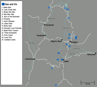
The Panorama Route is a scenic road in South Africa connecting several cultural and natural points of interest. This route, steeped in the history of South Africa, is situated in the Mpumalanga province. The route is centred around the Blyde River Canyon, the world’s third largest canyon, and features numerous waterfalls, one of the largest afforested areas in South Africa, and several natural landmarks. The route starts at the foot of the Long Tom Pass just outside Lydenburg, following the natural descent from the Great Escarpment to the Lowveld, and ending at the border of the Mpumalanga and Limpopo provinces near the Echo Caves.