Okatibbee Dam

Last updated
Okatibbee Dam
USACE Okatibbee Lake and Dam.jpg
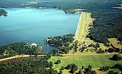
Okatibbee Lake and Dam on Okatibbee Creek, a tributary of the Chickasawhay River
CountryUnited States
Location Lauderdale County, Mississippi.
StatusOperational
Opening date1968
Designed byUnited States Army Corps of Engineers

Okatibbee Dam is a dam in Lauderdale County, Mississippi.

The earthen gravity dam was constructed in 1968 by the United States Army Corps of Engineers with a height of 72 feet and a length of 6620 at its crest. It impounds Okatibbee Creek for flood control and municipal drinking water. The dam is owned and operated by the Corps of Engineers. [1]

The reservoir it creates, Okatibbee Lake, has a water surface of 5.9 square miles, about 28 linear miles of shoreline, a maximum capacity of 59,481 acre-feet, and a normal storage capacity of 46,538 acre-feet. [2] Recreation includes boating, fishing, camping, hunting, and enjoying the five parks maintained by the Corps, one full service campground and four day-use parks. Directly north of the lake is the state's Okatibbee State Wildlife Area.

Related Research Articles

<span class="mw-page-title-main">Detroit Lake</span> Reservoir in Oregon, United States

Detroit Lake is a reservoir impounded by the Detroit Dam on the North Santiam River 46 miles (74 km) southeast of Salem, Oregon, United States. The lake is adjacent to Oregon Route 22 near the city of Detroit. This mesotrophic lake stores water for use by the city of Salem and other nearby communities.

<span class="mw-page-title-main">Keystone Lake</span> Dam in Oklahoma Pawnee / Osage / Creek / Tulsa counties, Oklahoma

Keystone Lake is a reservoir in northeastern Oklahoma on the Arkansas and Cimarron rivers. It is located upstream about 23 miles (37 km) from Tulsa. It was created in 1968 when the Keystone Dam was completed. The primary purposes are: flood control, hydroelectric power generation, wildlife management and recreation.

<span class="mw-page-title-main">Table Rock Lake</span> Man-made lake in Missouri and Arkansas, United States

Table Rock Lake is an artificial lake or reservoir in the Ozarks of southwestern Missouri and northwestern Arkansas in the United States. Designed, built and operated by the U.S. Army Corps of Engineers, the lake is impounded by Table Rock Dam, which was constructed from 1954 to 1958 on the White River.

<span class="mw-page-title-main">Yatesville Lake</span> Reservoir in Kentucky, United States

Yatesville Lake is a reservoir in Lawrence County, Kentucky in the far eastern part of the state, close to the town of Louisa.

<span class="mw-page-title-main">Wilson Lake (Kansas)</span> Reservoir in Russell and Lincoln counties in Kansas

Wilson Lake is a reservoir in the U.S. state of Kansas, on the border of Russell County and Lincoln County. Built and managed by the U.S. Army Corps of Engineers for flood control, it is also used for wildlife management and recreation. Several parks are located along its shoreline, including Wilson State Park.

<span class="mw-page-title-main">Isabella Dam</span> Dam in Kern County, California

Isabella Dam is an embankment dam located in the Kern River Valley, about halfway down the Kern River course, between the towns of Kernville and Lake Isabella in Kern County, California.

<span class="mw-page-title-main">Perry Lake (Kansas)</span> Reservoir in Jefferson County, Kansas

Perry Lake is a US Army Corps of Engineers operated reservoir in northeast Kansas. Its primary purposes are flood control, water reserve for nearby areas and regional recreation. The lake is approximately 11,150 acres (45 km²) in size, with over 160 miles (260 km) of shoreline. Perry Lake's full multi-purpose pool elevation is 891.5 feet (271.7 m) above sea level. Perry Lake is located about 40 miles (64 km) west of Kansas City, just northwest of Lawrence, Kansas. Its close proximity to Kansas City, Lawrence, and the state capitol, Topeka, make it a very popular destination, with the nickname "Paradise on the Plains".

<span class="mw-page-title-main">Optima Lake</span> Abandoned reservoir

Optima Lake was built to be a reservoir in Texas County, Oklahoma. The site is just north of Hardesty and east of Guymon in the Oklahoma Panhandle.

Green River Lake is a 8,210-acre (33 km2) reservoir in Adair, Taylor, and Casey counties in Kentucky lying in the section of Kentucky known as the Highland Rim.

<span class="mw-page-title-main">El Dorado Lake</span> Reservoir in Butler County, Kansas

El Dorado Lake is a reservoir on the Walnut River 0.5 miles (0.80 km) northeast of El Dorado in the Flint Hills region of Kansas. Built and managed by the U.S. Army Corps of Engineers, it is used for flood control, recreation, and water supply. El Dorado State Park is located on its shore.

<span class="mw-page-title-main">Grapevine Lake</span> Reservoir in Texas, United States

Grapevine Lake is a reservoir located in the North Texas region, about 20 mi (32 km) northwest of Dallas and northeast of Fort Worth. It was impounded in 1952 by the US Army Corps of Engineers when they dammed Denton Creek, a tributary of Trinity River.

<span class="mw-page-title-main">Lost Creek Lake</span> Reservoir in Jackson County, Oregon

Lost Creek Lake is a reservoir located on the Rogue River in Jackson County, Oregon, United States. The lake is impounded by William L. Jess Dam which was constructed by the U.S. Army Corps of Engineers in 1977 for flood control and fisheries enhancement. The lake and dam were the first completed elements of the multi-purpose Rogue River Basin Project, consisting of Lost Creek Lake, Applegate Lake and the Elk Creek project. The lake is located approximately 27 miles (43 km) northeast of Medford.

<span class="mw-page-title-main">Hugo Lake</span> Reservoir in Choctaw County, Oklahoma

Hugo Lake is manmade lake located 7 miles (11 km) east of Hugo, in Choctaw County, Oklahoma, United States. It is formed by Hugo Lake Dam on the Kiamichi River 18 miles (29 km) upstream from the Red River. The dam is visible from U.S. Route 70, which crosses its spillway just west of Sawyer. Lake Hugo features approximately 110 miles (180 km) of shoreline and covers over 13,250 acres (53.6 km2), or 20 square miles (52 km2). Its normal pool elevation is 404.5 feet (123.3 m) above sea level and its normal storage capacity is 157,600 acre-feet (194,400,000 m3). At flood stage its elevation is at 437.5 feet (133.4 m) above sea level and it is capable of storing 966,700 acre-feet (1.1924×10⁹ m3) of flood waters. The lake's primary functions are to provide flood control, water storage, and recreational opportunities.

<span class="mw-page-title-main">John Redmond Reservoir</span> Reservoir in Coffey County, Kansas

John Redmond Reservoir is a reservoir on the Neosho River in eastern Kansas. Built and managed by the U.S. Army Corps of Engineers, it is used for flood control, recreation, water supply, and wildlife management. It borders the Flint Hills National Wildlife Refuge to the northwest.

<span class="mw-page-title-main">Kanopolis Lake</span> Reservoir in Ellsworth County, Kansas

Kanopolis Lake is a reservoir in Ellsworth County in the Smoky Hills of central Kansas, about 31 miles southwest of Salina and a few miles southeast of the town of Kanopolis. The lake is formed by Kanopolis Dam. Completed in 1948 as a flood control and water conservation project of the United States Army Corps of Engineers, the dam impounds the Smoky Hill River.

<span class="mw-page-title-main">Council Grove Lake</span> Reservoir in Morris County, Kansas

Council Grove Lake is a reservoir on the Neosho River in east-central Kansas. Built and managed by the U.S. Army Corps of Engineers, it is used for flood control, recreation, and water supply.

<span class="mw-page-title-main">Cherry Creek Dam</span> Dam

Cherry Creek Dam is a dam in Arapahoe County, Colorado southeast of Denver.

<span class="mw-page-title-main">Copan Dam</span> Dam in Washington County, Oklahoma

Copan Dam is a dam in Washington County, Oklahoma, in the northeastern part of the state.

<span class="mw-page-title-main">Mahoning Creek Dam</span> Dam in Armstrong County, Pennsylvania, US

The Mahoning Creek Dam is a dam in Armstrong County, Pennsylvania.

<span class="mw-page-title-main">John Martin Reservoir</span> Reservoir in Colorado, United States

John Martin Reservoir is a reservoir on the Arkansas River in Bent County in southeastern Colorado. Built and managed by the U.S. Army Corps of Engineers, it is used for flood control, irrigation, and recreation. John Martin Reservoir State Park lies on its shore.

References

  1. "Woolen Lake Gassoway Lake Horseshoe Lake Area". Archived from the original on 2012-09-15. Retrieved 2012-08-17.
  2. "Okatibbee Lake". Archived from the original on January 13, 2008. Retrieved June 9, 2008.

32°28′33″N88°47′52″W / 32.4759°N 88.7979°W / 32.4759; -88.7979