This is a list of the extreme points of the United Kingdom: the points that are farther north, south, east or west than any other location. Traditionally the extent of the island of Great Britain has stretched "from Land's End to John o' Groats".
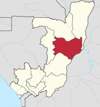
Cuvette is a department of the Republic of the Congo in the central part of the country. It borders the departments of Cuvette-Ouest, Likouala, Plateaux, and Sangha, and internationally, the Democratic Republic of the Congo. The capital is Owando. Cities and towns include Boundji, Makoua and Okoyo.

USS Strong (DD-467), was a Fletcher-class destroyer and the first ship of the United States Navy to be named after Rear Admiral James H. Strong (1814–1882), who rammed the Confederate ironclad CSS Tennessee during the Battle of Mobile Bay, receiving a commendation and promotion to captain.

The Usarp Mountains are a major mountain range in North Victoria Land, Antarctica. They are west of the Rennick Glacier and trend north to south for about 190 kilometres (118 mi). The mountains are bounded to the north by Pryor Glacier and the Wilson Hills. They are west of the Bowers Mountains.

The Alima River is a tributary of the Congo River. It is formed by the confluence of two streams, the Lékéti and the Dziélé.
The Departments of the Republic of the Congo are divided into 86 districts and 6 communes; which are further subdivided into urban communities and rural communities ; which are further subdivided into quarters or neighborhoods (quartiers) and villages. Note the departments of Brazzaville and Pointe-Noire are made of 1 commune each, then divided in urban districts (arrondissements).

Tepuka Vili Vili or Tepuka Savilivili is an islet of Funafuti, Tuvalu.

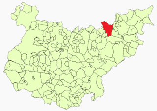
Calzadilla de Tera is a municipality located in the province of Zamora, Castile and León, Spain. According to the 2004 census (INE), the municipality has a population of 467 inhabitants.
Táborfalva is a village in Pest county, Hungary.
Kəhrəmanlı is a village in the Yevlakh Rayon of Azerbaijan.
Dortlyar is a village in the Neftchala Rayon of Azerbaijan. The village forms part of the municipality of Boyat.
Navalvillar de Pela is a Spanish municipality in the province of Badajoz, Extremadura. It has a population of 4,816 (2007) and an area of 251.2 km2.
Buen Pasto is a village and municipality in Chubut Province in southern Argentina.
Kingli is a village in Saaremaa Parish, Saare County in western Estonia.
Zaborani is a village in the municipality of Nevesinje, Republika Srpska, Bosnia and Herzegovina.
Mackellar Inlet is an inlet forming the northwestern head of Admiralty Bay, at King George Island in the South Shetland Islands. It was probably named by the Fourth French Antarctic Expedition under Jean-Baptiste Charcot, who charted Admiralty Bay in December 1909. Wegger Peak stands on the west side of the inlet entrance.

Haut-Katanga District is a former district located in the former Katanga Province of the Democratic Republic of the Congo. The copper mining centers of Lubumbashi and Likasi were surrounded by the district but were administratively separate.
Okoyo Airport is an airstrip serving the town of Okoyo in the Cuvette Department of the Republic of the Congo. The runway is 1.5 kilometres (1 mi) north of the town.
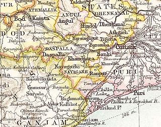
Narsinghpur State was one of the princely states of India during the British Raj. The state was founded in the 17th century and had its capital in Narasinghpur town. The last ruler of Narsinghpur joined the state to the Indian Union in 1948 and Narsinghpur state was made part of the Cuttack district of Odisha.
