Olcott-Newfane Airport

Last updated
Olcott-Newfane Airport
Summary
Airport type Public use
Owner Bruce Erck
Serves Olcott, New York
Elevation  AMSL 315 ft / 96 m
Coordinates 43°19′18″N078°43′30″W / 43.32167°N 78.72500°W / 43.32167; -78.72500 Coordinates: 43°19′18″N078°43′30″W / 43.32167°N 78.72500°W / 43.32167; -78.72500
Map
USA New York location map.svg
Airplane silhouette.svg
D80
Location of airport in New York
Runways
Direction Length Surface
ft m
9/27 2,500 762 Turf
6/24 2,408 734 Turf

Olcott-Newfane Airport( FAA LID : D80) is a privately owned, public use airport located two  nautical miles (4  km) southwest of Olcott, a hamlet in the Town of Newfane, Niagara County, New York, United States. [1] This airport is currently closed indefinitely. [1]

Federal Aviation Administration United States Government agency dedicated to civil aviation matters

The Federal Aviation Administration (FAA) is a governmental body of the United States with powers to regulate all aspects of civil aviation in that nation as well as over its surrounding international waters. Its powers include the construction and operation of airports, air traffic management, the certification of personnel and aircraft, and the protection of U.S. assets during the launch or re-entry of commercial space vehicles. Powers over neighboring international waters were delegated to the FAA by authority of the International Civil Aviation Organization.

A location identifier is a symbolic representation for the name and the location of an airport, navigation aid, or weather station, and is used for manned air traffic control facilities in air traffic control, telecommunications, computer programming, weather reports, and related services.

Airport location where aircraft take off and land

An airport is an aerodrome with extended facilities, mostly for commercial air transport. Airports often have facilities to store and maintain aircraft, and a control tower. An airport consists of a landing area, which comprises an aerially accessible open space including at least one operationally active surface such as a runway for a plane to take off or a helipad, and often includes adjacent utility buildings such as control towers, hangars and terminals. Larger airports may have airport aprons, taxiway bridges, air traffic control centres, passenger facilities such as restaurants and lounges, and emergency services. In some countries, the US in particular, they also typically have one or more fixed-base operators, serving general aviation.

Contents

Facilities

Olcott-Newfane Airport covers an area of 60 acres (24 ha) at an elevation of 315 feet (96 m) above mean sea level. It has two runways with turf surfaces: 9/27 is 2,500 by 60 feet (762 x 18 m) and 6/24 is 2,408 by 30 feet (734 x 9 m). [1]

Acre unit of area

The acre is a unit of land area used in the imperial and US customary systems. It is traditionally defined as the area of one chain by one furlong, which is exactly equal to 10 square chains, ​1640 of a square mile, or 43,560 square feet, and approximately 4,047 m2, or about 40% of a hectare. Based upon the International yard and pound agreement of 1959, an acre may be declared as exactly 4,046.8564224 square metres. The acre is a statute measure in the United States and was formerly one in the United Kingdom and almost all countries of the former British Empire, although informal use continues.

Hectare metric unit of area

The hectare is an SI accepted metric system unit of area equal to a square with 100-metre sides, or 10,000 m2, and is primarily used in the measurement of land. There are 100 hectares in one square kilometre. An acre is about 0.405 hectare and one hectare contains about 2.47 acres.

Elevation Height of a geographic location above a fixed reference point

The elevation of a geographic location is its height above or below a fixed reference point, most commonly a reference geoid, a mathematical model of the Earth's sea level as an equipotential gravitational surface . The term elevation is mainly used when referring to points on the Earth's surface, while altitude or geopotential height is used for points above the surface, such as an aircraft in flight or a spacecraft in orbit, and depth is used for points below the surface.

Related Research Articles

Newfane, New York Town in New York, United States

Newfane is a town in Niagara County, New York, United States. The population was 9,666 at the 2010 census. The name was suggested by an early settler.

North Palm Beach County General Aviation Airport airport in Florida, United States of America

North Palm Beach County Airport, also known as North County Airport, is an uncontrolled general aviation airport located 12 nautical miles (22 km) northwest of West Palm Beach off the Bee Line Highway in Palm Beach Gardens, Florida. The airport is owned by Palm Beach County and operated by the Palm Beach County Airports Department.

Willows-Glenn County Airport airport in California, United States of America

Willows-Glenn County Airport is a county-owned, public-use airport located one nautical mile (2 km) west of the central business district of Willows, a city in Glenn County, California, United States. This airport is included in the National Plan of Integrated Airport Systems for 2011–2015, which categorized it as a general aviation facility. It is also known as Willows-Glenn Airport.

Oakes Municipal Airport is a public airport located two miles (3 km) north of the central business district of Oakes, a city in Dickey County, North Dakota, United States. It is owned by the Oakes Airport Authority.

Orlando Apopka Airport airport in Florida, United States of America

Orlando Apopka Airport is a privately owned, uncontrolled, public-use airport located four nautical miles (7 km) northwest of the central business district of Apopka, in Orange County, Florida, United States. It was previously known as Orlando Country Airport and McDonald Airport prior to that, the latter due its proximity to the unincorporated community of McDonald, Florida.

Wetumpka Municipal Airport airport in Alabama, United States of America

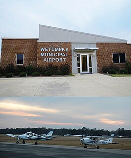
Wetumpka Municipal Airport is a city-owned, public-use airport located six nautical miles west of the central business district of Wetumpka, a city in Elmore County, Alabama, United States. It is included in the FAA's National Plan of Integrated Airport Systems for 2011–2015, which categorized it as a general aviation facility. During World War II the airport, known then as Elmore Auxiliary Field, served as an auxiliary field for Gunter Army Airfield training operations. In 2013 the airport was listed in the Alabama Register of Landmarks and Heritage.

Clayton Municipal Airport (Alabama) airport in Alabama, United States of America

Clayton Municipal Airport is a city-owned, public-use airport located two nautical miles west of the central business district of Clayton, a city in Barbour County, Alabama, United States.

Headland Municipal Airport airport in Alabama, United States

Headland Municipal Airport is a city-owned, public-use airport located two nautical miles northeast of the central business district of Headland, a city in Henry County, Alabama, United States.

Fremont Airport is a public-use airport located two nautical miles (4 km) southwest of the central business district of Fremont, a city in Sandusky County, Ohio, United States. It is privately owned by Fremont Airport LLC.

Delta Junction Airport airport in Alaska, United States of America

Delta Junction Airport is a public use airport located in and owned by Delta Junction, a city in the Southeast Fairbanks Census Area of the U.S. state of Alaska.

Post Mills Airport airport in Orange County, United States of America

Post Mills Airport is a privately owned, public use airport in Orange County, Vermont, United States. It is located within the central business district of the Village of Post Mills.

Luther Airport is a public use airport located one nautical mile east of the central business district of Chittenango, a village in the Town of Sullivan in Madison County, New York, United States.

Frank Sikes Airport airport in Alabama, United States of America

Frank Sikes Airport is a city-owned public-use airport located two nautical miles north of the central business district of Luverne, a city in Crenshaw County, Alabama, United States.

Stevenson Airport is a city-owned public-use airport located two nautical miles southwest of the central business district of Stevenson, a city in Jackson County, Alabama, United States.

Moundville Airport is a privately owned, public-use airport in Hale County, Alabama, United States. It is located two nautical miles south of the central business district of Moundville, Alabama.

Pine Hill Municipal Airport is a town-owned public-use airport located one nautical mile south of the central business district of Pine Hill, a town in Wilcox County, Alabama, United States.

Sher-Wood Airport is a public use airport located one nautical mile (2 km) northeast of the central business district of Plentywood, a city in Sheridan County, Montana, United States. It is owned by the city and county. This airport is included in the National Plan of Integrated Airport Systems for 2011–2015, which categorized it as a general aviation facility.

Arcade Tri-County Airport airport in New York, United States of America

Arcade Tri-County Airport is a privately owned, public use airport located two nautical miles (4 km) north of Arcade, a village in the Town of Arcade, Wyoming County, New York, United States.

Plymouth Municipal Airport (Indiana) airport in Indiana, United States of America

Plymouth Municipal Airport is a public use airport located two nautical miles (4 km) north of the central business district of Plymouth, a city in Marshall County, Indiana, United States. It is owned by the Plymouth Board of Aviation of Commissioners. This airport is included in the National Plan of Integrated Airport Systems for 2011–2015, which categorized it as a general aviation facility.

Crivitz Municipal Airport airport in Marinette County, United States of America

Crivitz Municipal Airport, is a city owned public use airport located 3 miles (5 km) southwest of the central business district of Crivitz, Wisconsin, a city in Marinette County, Wisconsin, United States. It is included in the Federal Aviation Administration (FAA) National Plan of Integrated Airport Systems for 2019–2023, in which it is categorized as a basic general aviation facility.

References

  1. 1 2 3 4 FAA Airport Master Record for D80 ( Form 5010 PDF ). Federal Aviation Administration. Effective November 15, 2012.
The National Map

The National Map is a collaborative effort of the United States Geological Survey (USGS) and other federal, state, and local agencies to improve and deliver topographic information for the United States. The purpose of the effort is to provide "...a seamless, continuously maintained set of public domain geographic base information that will serve as a foundation for integrating, sharing, and using other data easily and consistently".