
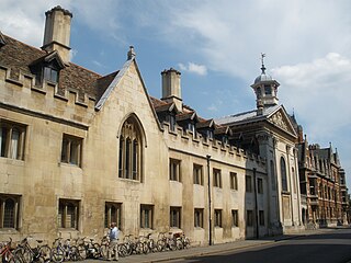
Peterhouse is the oldest constituent college of the University of Cambridge in England, founded in 1284 by Hugh de Balsham, Bishop of Ely. Peterhouse has around 300 undergraduate and 175 graduate students, and 54 fellows.

Cambridge is a city and non-metropolitan district in the county of Cambridgeshire, England. It is the county town of Cambridgeshire and is located on the River Cam, 55 miles (89 km) north of London. As of the 2021 United Kingdom census, the population of the City of Cambridge was 145,700; the population of the wider built-up area was 181,137. Cambridge became an important trading centre during the Roman and Viking ages, and there is archaeological evidence of settlement in the area as early as the Bronze Age. The first town charters were granted in the 12th century, although modern city status was not officially conferred until 1951.

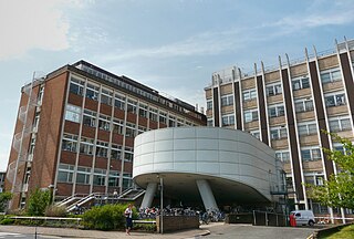
Fitzwilliam College is a constituent college of the University of Cambridge.

St Catharine's College is a constituent college of the University of Cambridge. Founded in 1473 as Katharine Hall, it adopted its current name in 1860. The college is nicknamed "Catz". The college is located in the historic city-centre of Cambridge, and lies just south of King's College and across the street from Corpus Christi College. The college is notable for its open court that faces towards Trumpington Street.

The Fitzwilliam Museum is the art and antiquities museum of the University of Cambridge. It is located on Trumpington Street opposite Fitzwilliam Street in central Cambridge. It was founded in 1816 under the will of Richard FitzWilliam, 7th Viscount FitzWilliam (1745–1816), and comprises one of the best collections of antiquities and modern art in western Europe. With over half a million objects and artworks in its collections, the displays in the museum explore world history and art from antiquity to the present. The treasures of the museum include artworks by Monet, Picasso, Rubens, Vincent van Gogh, Renoir, Rembrandt, Cézanne, Van Dyck, and Canaletto, as well as a winged bas-relief from Nimrud. Admission to the public is always free.

Addenbrooke's Hospital is a large teaching hospital and research centre in Cambridge, England, with strong affiliations to the University of Cambridge. Addenbrooke's Hospital is located on the Cambridge Biomedical Campus. It is run by Cambridge University Hospitals NHS Foundation Trust and is a designated academic health science centre. It is also the East of England's major trauma centre and was the first such centre to be operational in the United Kingdom.

The A1309 is a short road which links the two ends of the A10 to north and south of Cambridge city centre in Cambridgeshire, England. It was numbered as part of the A10 prior to the construction of the Cambridge Western Bypass and the Northern Bypass.

Cambridge Judge Business School is the business school of the University of Cambridge. The School is a provider of management education. It is named after Sir Paul Judge, a founding benefactor of the school. The School is a department of the university's School of Technology administrative group.

The Downing Site is a major site of the University of Cambridge, located in the centre of the city of Cambridge, England, on Downing Street and Tennis Court Road, adjacent to Downing College. The Downing Site is the larger and newer of two city-centre science sites of the university. Largely populated with utilitarian brick buildings dating from the 1930s, the more notable buildings include the Zoology Laboratory (1900–04), Sedgwick Museum of Earth Sciences (1904–11) and Downing Street entrance (1904–11).

Hobson's Conduit, also called Hobson's Brook, is a watercourse that was built from 1610 to 1614 by Thomas Hobson and others to bring fresh water into the city of Cambridge, England from springs at Nine Wells, a Local Nature Reserve, near the village of Great Shelford. It is now a Scheduled Ancient Monument and historical relic. The watercourse currently runs overground until Cambridge University Botanic Garden and Brookside, where it is at its widest. At the corner of Lensfield Road stands a hexagonal monument to Hobson, which once formed part of the market square fountain, and was moved to this location in 1856, after a fire in the Market. The flow of water runs under Lensfield Road, and subsequently runs along both sides of Trumpington Street in broad gutters towards Peterhouse and St Catharine's College, and also St Andrew's Street. The conduit currently ends at Silver Street.

The Museum of Archaeology and Anthropology, also known as MAA, at the University of Cambridge houses the university's collections of local antiquities, together with archaeological and ethnographic artefacts from around the world. The museum is located on the university's Downing Site, on the corner of Downing Street and Tennis Court Road. In 2013 it reopened following a major refurbishment of the exhibition galleries, with a new public entrance directly on to Downing Street.
Trumpington Street is a major historic street in central Cambridge, England. At the north end it continues as King's Parade where King's College is located. To the south it continues as Trumpington Road, an arterial route out of Cambridge, at the junction with Lensfield Road.

Trumpington Road is an arterial road in southeast central Cambridge, England. It runs between the junction of Trumpington Street and Lensfield Road at the northern end to the junction of the High Street in the village of Trumpington and Long Road at the southern end. The Fen Causeway leads off to the west near the northern end, over Coe Fen and the River Cam.

Pembroke Street is a street in central Cambridge, England. It runs between Downing Street and Tennis Court Road at the eastern end and a junction with Trumpington Street at the western end. It continues west on the other side of Trumpington Street as Mill Lane.

Tennis Court Road is a historic street in central Cambridge, England. It runs parallel with Trumpington Street to the west and Regent Street to the east. At the northern end is a junction with Pembroke Street to the west and Downing Street to the east. To the south as a T-junction with Lensfield Road. Fitzwilliam Street leads off the road to the west towards the Fitzwilliam Museum.
Hills Road is an arterial road in southeast Cambridge, England. It runs between Regent Street at the junction with Lensfield Road and Gonville Place to the northwest and a roundabout by the Cambridge Biomedical Campus, continuing as Babraham Road to the southeast.
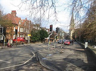
Lensfield Road is a road in southeast central Cambridge, England. It runs between the junction of Trumpington Street and Trumpington Road to the west and the junction of Regent Street and Hills Road to the west. It continues as Gonville Place to the northeast past Parker's Piece, a large grassy area with footpaths.
David Wyn Roberts was a British architect and educator, who designed more university buildings for Cambridge University than any other architect. With a modernist practice based in Cambridge, he also designed many city housing projects, schools, and private residences.
