
An arch bridge is a bridge with abutments at each end shaped as a curved arch. Arch bridges work by transferring the weight of the bridge and its loads partially into a horizontal thrust restrained by the abutments at either side, and partially into a vertical load on the arch supports. A viaduct may be made from a series of arches, although other more economical structures are typically used today.

Bridgend is a town in the Bridgend County Borough of Wales, 20 miles (32 km) west of Cardiff and 20 miles (32 km) east of Swansea. The town is named after the medieval bridge over the River Ogmore. The River Ewenny also flows through the town. The population was 49,597 in 2021. Bridgend is within the Cardiff Capital Region which in 2019 had a population of approximately 1.54 million.

Bridgend County Borough is a county borough in the south-east of Wales. The county borough has a total population of 139,200 people, and contains the town of Bridgend, after which it is named. Its members of the Senedd are Sarah Murphy MS, representing the Bridgend Constituency, and Huw Irranca-Davies MS representing the Ogmore Constituency, and its members of the UK parliament are Chris Bryant, Chris Elmore, and Stephen Kinnock.

The River Ogmore is a river in South Wales that is popular with anglers. It runs generally from north to south from the Ogmore Vale and Gilfach Goch, past Bridgend and Ogmore. The River Ogmore rises at Craig Ogwr in the Ogmore Valley as the Ogwr Fawr before it links with the Ogwr Fach at Blackmill. The River Llynfi, the River Garw and finally the River Ewenny in its estuary are all tributaries of the Ogmore which flows into the sea between Ogmore-by-Sea and the Merthyr Mawr sand-dunes.

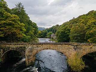
Ogmore Castle is a Grade I listed castle ruin located near the village of Ogmore in the Vale of Glamorgan, Wales, east of Ogmore-by-Sea, and south of the town of Bridgend. It is situated on the south bank of the Ewenny River and the east bank of the River Ogmore.

Ogmore was a constituency created in 1918, represented in the House of Commons of the UK Parliament.

Merthyr Mawr is a village and community in Bridgend, Wales. The village is about 2+1⁄2 miles from the centre of Bridgend town. The population of the community at the 2011 census was 267. The community occupies the area west of the Ewenny River, between Bridgend and Porthcawl. It takes in the settlement of Tythegston and a stretch of coastal sand dunes known as Merthyr Mawr Warren. It is in the historic county of Glamorgan.

The Welsh Bridge is a masonry arch viaduct in the town of Shrewsbury, England, which crosses the River Severn. It connects Frankwell with the town centre. It is a Grade II* listed building.

William Edwards was a Welsh Methodist minister who also practised as a stonemason, architect and bridge engineer.

Pontarddulais, also spelled Pontardulais, is town and community in Swansea, Wales. It is 10 miles (16 km) northwest of the city centre. It is in the Pontarddulais ward of the City and County of Swansea Council. Pontarddulais adjoins the village of Hendy in Carmarthenshire. The built-up population was 9,073.
The Garw Valley Railway is the trading name of the Bridgend Valleys Railway Company Limited. It operates a short section of 4 ft 8+1⁄2 instandard gauge railway located in South Wales, which is being recreated as a heritage railway. Formerly part of the Llynvi and Ogmore Railway (L&OR) and built by the Great Western Railway (GWR), the line was used for freight and passenger services, with most of the track still in place between Brynmenyn and Pontycymer. The project currently has a train shed at Pontycymer, and hopes to initially offer brake van rides between Pontycymer and Pant-y-Gog, a distance of 0.5 miles (0.8 km).

The Patterson Viaduct was built by the Baltimore and Ohio Railroad (B&O) as part of its Old Main Line during May to December 1829. The viaduct spanned the Patapsco River at Ilchester, Maryland. It was heavily damaged by a flood in 1868 and subsequently replaced with other structures. In 2006, it was restored to limited service when a footbridge was built atop the surviving arch and abutments.

The Ewenny River is a river in South Wales. For most of its 10 miles (16 km) length, it forms the border between the Vale of Glamorgan and Bridgend. It is a major tributary of the River Ogmore, which it joins near its estuary.

Perth Bridge is a toll-free bridge in the city of Perth, Scotland. A Category A listed structure, it spans the River Tay, connecting Perth, on the western side of the river, to Bridgend, on its eastern side, carrying both automotive and pedestrian traffic of West Bridge Street. An earlier bridge was demolished at the same location in 1621, and many unsuccessful attempts were made to replace it. A subscription was started by James VI and several noblemen to help with the construction cost, but the king's death in 1625 suspended the scheme and a series of ferryboats were instead used.

The Old Bridge, which is now also known as the William Edwards Bridge or Pontypridd Bridge, was originally known as the New Bridge or Newbridge, is an arched single-span footbridge that spans the River Taff at Pontypridd in Wales. The bridge was built by William Edwards and was completed in 1756. The bridge now has statutory protection as a scheduled ancient monument and is grade I listed.

Ynysawdre is a small community in Bridgend County Borough, south Wales. It is located to the east of Aberkenfig in Wales, and comprises the two villages of Tondu and Brynmenyn. The name Ynysawdre is also usually used for a small section of Tondu. At the 2001 census, the population of the community was 3,698, reducing to 3,367 at the 2011 Census.

St Brides Major is a community on the western edge of the Vale of Glamorgan, South Wales. Its largest settlement is the village of St Brides Major, and also includes the villages of Ogmore-by-Sea and Southerndown, and the hamlets of Ogmore Village, Castle-upon-Alun, Heol-y-Mynydd, Norton and Pont-yr-Brown It is notable for coastal geology and scenery, limestone downlands and fossilised primitive mammals, sea cliffs and beaches, two Iron Age hillforts, three medieval castle sites,, two stepping stone river crossings and a clapper bridge. Three long distance paths cross the community. It is the western limit of the Vale of Glamorgan Heritage Coast, and has a visitor centre and tourist facilities.
Pont Cysyllte, also known as Cysylltau Bridge or Bont Bridge, is a 17th-century road bridge crossing the River Dee near the village of Trevor, Wrexham County Borough, Wales. It lies 200 m west of Thomas Telford's Pontcysyllte Aqueduct and, carrying the B5434 road, is the main connection between Trevor and nearby Froncysyllte.
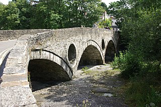
Cenarth Bridge, also spelt Kenarth Bridge, is a three arch bridge which spans the River Teifi at Cenarth, Carmarthenshire in Wales. The bridge was built between 1785 and 1787 and designed by David Edwards, the son of William Edwards who built the Old Bridge at Pontypridd. The bridge straddles the border between Carmarthenshire and Ceredigion. It is both a Grade II* listed structure and a scheduled monument.

Pont Minllyn is a bridge spanning the River Dyfi, south of the village of Dinas Mawddwy, in Gwynedd, Wales. It was built by John Davies, rector of Mallwyd between 1603 and 1644 and a famed Welsh scholar who wrote a Welsh grammar and worked on early Welsh translations of the Bible and the Book of Common Prayer. Pont Minllyn was designed as a packhorse bridge to facilitate the transportation of goods. It is a Grade II listed building and a Scheduled monument.


