Richmond Lock and Footbridge is a lock, rising and falling low-tide barrage integrating controlled sluices and pair of pedestrian bridges on the River Thames in south west London, England and is a Grade II* listed structure. It is the furthest downstream of the forty-five Thames locks and the only one owned and operated by the Port of London Authority. It was opened in 1894 and is north-west of the centre of Richmond in a semi-urban part of south-west London. Downstream are Syon Park and Kew Gardens on opposite banks. It connects the promenade at Richmond with the neighbouring district of St. Margarets on the west bank during the day and is closed at night to pedestrians - after 19:30 GMT or after 21:30 when BST is in use. At high tide the sluice gates are raised and partly hidden behind metal arches forming twin footbridges.

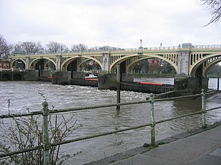
Teddington Lock is a complex of three locks and a weir on the River Thames in England between Ham and Teddington in the London Borough of Richmond upon Thames. It was first built in 1810.

Caversham Lock is a lock and main weir on the River Thames in England at Reading, Berkshire. Both structures connect to De Bohun Island, a long island. The original lock was built by the Thames Navigation Commissioners in 1778. Additional sluices north of verdant View Island and multiple home Heron Island form the whole weir complex. A footbridge passes over all three islands to connect Lower Caversham to Reading via an alternative route than George Street and Reading Bridge.

Cookham Lock is a lock with weirs situated on the River Thames near Cookham, Berkshire. The lock is set in a lock cut which is one of four streams here and it is surrounded by woods. On one side is Sashes Island and on the other is Mill Island connected to Formosa Island, the largest on the non-tidal Thames.

The Thames Path is a National Trail following the River Thames from its source near Kemble in Gloucestershire to the Thames Barrier at Charlton, south east London. It is about 184 miles (296 km) long. A path was first proposed in 1948 but it only opened in 1996.
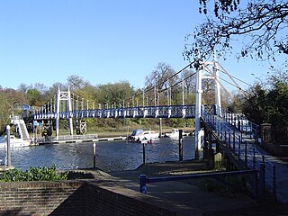
Teddington Lock Footbridge consists of two separate bridges across the River Thames in England situated just upstream of Teddington Lock at Teddington. There is a small island between the bridges.

Folly Bridge is a stone bridge over the River Thames carrying the Abingdon Road south from the centre of Oxford, England. It was erected in 1825–27, to designs of a little-known architect, Ebenezer Perry, who practised in London.

The Thames Conservancy was a historical body responsible for the management of the River Thames in England. It was founded in 1857, initially replacing the jurisdiction of the City of London up to Staines and later taking responsibility for the whole river from Cricklade in Wiltshire to the sea at Yantlet Creek on the Isle of Grain. Responsibilities were reduced when the Tideway was transferred to the Port of London Authority in 1909 and in 1974 the Conservancy was taken into the Thames Water Authority.

Benson Lock is a lock on the River Thames in England, close to Benson, Oxfordshire but on the opposite bank of the river. The first pound lock here was built by the Thames Navigation Commission in 1788 and it was replaced by the present masonry lock in 1870. The distance between Benson Lock and Cleeve Lock downstream is 6.5 miles (10.4 km) - the longest distance between locks on the River Thames.

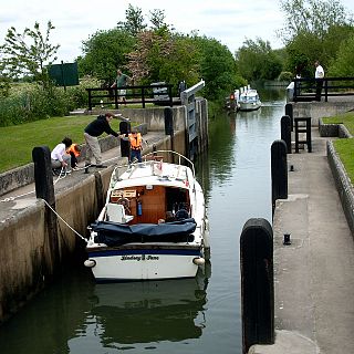
Sunbury Lock is a lock complex of the River Thames in England near Walton-on-Thames in north-west Surrey, the third lowest of forty four on the non-tidal reaches. The complex adjoins the right, southern bank about 1⁄2 mile (0.80 km) downstream of the Weir Hotel.

Old Windsor Lock is a lock on the River Thames in England on the right bank beside Old Windsor, Berkshire. The lock marks the downstream end of the New Cut, a meander cutoff built in 1822 by the Thames Navigation Commissioners which created Ham Island. The lock and a wider footbridge give access to the island. Two weirs are associated; the smaller adjoins and the larger is upstream. The lock is the ninth lowest of the forty-five on the river.
Boveney Lock is a lock on the River Thames situated on the Buckinghamshire bank opposite the Windsor Racecourse and close to Eton Wick. Boveney is a village a little way upstream on the same side. The lock was first built in 1838 by the Thames Navigation Commission. The lock was rebuilt in 1898 closer to the Buckinghamshire bank, and a set of boat rollers were installed on the old site.
Shifford Lock is a lock on the River Thames in England. It is in the centre of a triangle formed by the small villages of Shifford, Duxford and Chimney in Oxfordshire. It is at the start of a navigation cut built with the lock by the Thames Conservancy in 1898. It replaced a flash lock in a weir about 3/4 mile downstream.
Radcot Lock is a lock on the River Thames in England just downstream of Radcot, Oxfordshire, on the southern bank.

Tenfoot Bridge is a wooden footbridge across the River Thames in Oxfordshire, England. It is situated on the reach above Shifford Lock and was built in 1869. It connects Buckland on the south bank to Chimney on the north.
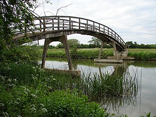
Hart's Weir Footbridge is a single-span concrete footbridge across the River Thames in Oxfordshire, England. Locally, it is also known as Rainbow Bridge, due to its rainbow-arc appearance as seen from the horizon. It is situated on the reach above Northmoor Lock, the nearest village being Appleton, Oxfordshire to the east.

Eaton Footbridge is a wooden footbridge across the River Thames in Oxfordshire, England. It is situated on the reach above Grafton Lock.

Bloomers Hole Footbridge is a footbridge across the River Thames in Oxfordshire, England. It is situated on the reach above Buscot Lock and was installed in 2000 to carry the Thames Path across the Thames. It is built of steel encased in wood to make it look like a timber structure.