Marlborough may refer to:

Concord is a town in Middlesex County, Massachusetts, in the United States. At the 2020 census, the town population was 18,491. The United States Census Bureau considers Concord part of Greater Boston. The town center is near where the confluence of the Sudbury and Assabet rivers forms the Concord River.

Sudbury is a town in Middlesex County, Massachusetts, United States. At the 2020 census, it had a population of 18,934. The town, located in Greater Boston's MetroWest region, has a rich colonial history.

Maynard is a town in Middlesex County, Massachusetts, United States. The town is located 22 miles west of Boston, in the MetroWest and Greater Boston region of Massachusetts and borders Acton, Concord, Stow and Sudbury. The town's population was 10,746 as of the 2020 United States Census.
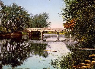
The Concord River is a 16.3-mile-long (26.2 km) tributary of the Merrimack River in eastern Massachusetts in the United States. The river drains a small rural and suburban region northwest of Boston. One of the most notable small rivers in U.S. history, it was the scene of an important early battle of the American Revolutionary War and was the subject of a 19th-century book by Henry David Thoreau.

The Assabet River is a small, 34.4-mile (55.4 km) long river located about 20 miles (30 km) west of Boston, Massachusetts, United States. The Assabet rises from a swampy area known as the Assabet Reservoir in Westborough, Massachusetts, and flows northeast before merging with the Sudbury River at Egg Rock in Concord, Massachusetts, to become the Concord River. The Organization for the Assabet, Sudbury and Concord Rivers, headquartered in West Concord, Massachusetts, is a non-profit organization dedicated to the preservation, protection, and enhancement of the natural and recreational features of these three rivers and their watershed. As the Concord River is a tributary of the Merrimack River, it and the Assabet and Sudbury rivers are part of the larger Merrimack River watershed.

The Old Connecticut Path was the Native American trail that led westward from the area of Massachusetts Bay to the Connecticut River Valley, the first of the North American trails that led west from the settlements close to the Atlantic seacoast, towards the interior. The earliest colonists of Massachusetts Bay Colony used it, and rendered it wider by driving cattle along it. The old route is still followed, for part of its length, by Massachusetts Route 9 and Massachusetts Route 126.
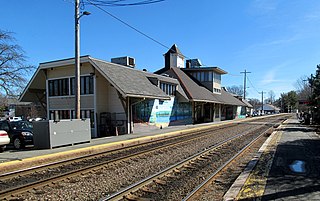
Concord Depot is a commuter rail station on the MBTA Commuter Rail Fitchburg Line at 90 Thoreau Street in downtown Concord, Massachusetts. As well as providing commuter service to Boston, the station offers tourists access to the various popular historic sites in Concord. It has two side platforms, which are low-level and not handicapped accessible, serving the line's two tracks. Although the station is within walking distance of the most heavily populated area of Concord, a small number of free parking spots are also available.
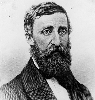
Walking, or sometimes referred to as "The Wild", is a lecture by Henry David Thoreau first delivered at the Concord Lyceum on April 23, 1851. It was written between 1851 and 1860, but parts were extracted from his earlier journals. Thoreau read the piece a total of ten times, more than any other of his lectures. "Walking" was first published as an essay in the Atlantic Monthly after his death in 1862.

The Assabet River Rail Trail (ARRT) is a partially-completed multi-use rail trail running through the cities and towns of Marlborough, Hudson, Stow, Maynard, and Acton, Massachusetts, United States. It is a conversion of the abandoned Marlborough Branch of the Fitchburg Railroad. The right-of-way parallels the Assabet River in the trail's midsection. At the north end it veers north to the South Acton MBTA train station while the south end veers south to Marlborough. When fully completed, the end-to-end length will be 12.5 miles (20.1 km). As of June 2020, the southwest 5.1-mile (8.2 km) portion of the trail from Marlborough to Hudson and the northeast 3.4-mile (5.5 km) portion running from the South Acton MBTA station to the Maynard–Stow border are completed. No current plans exist for paving the 4.0-mile (6.4 km) gap in Stow and Hudson between the two trail ends.

The Assabet River National Wildlife Refuge is a 2,230-acre (9.0 km2) protected National Wildlife Refuge located approximately 25 miles (40 km) west of Boston and 4 miles (6.4 km) west of the Eastern Massachusetts National Wildlife Refuge Complex Headquarters, along the Assabet River. It is located in portions of the towns of Hudson, Maynard, Stow and Sudbury. The Assabet River National Wildlife Refuge consists of two separate pieces of land. The larger northern section is just north of Hudson Road, extending north to the Assabet River. The southern section is located to the south of Hudson Road. There is a visitor center located in the northern section on Winterberry Way.
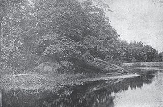
Egg Rock is an outcrop of Silurian Straw Hollow Diorite at the confluence of the Assabet and Sudbury rivers, where they form the Concord River in Concord, Massachusetts. The outcrop is located on a roughly oval intermittent island of about 100 by 50 meters. Egg Rock is usually accessible using foot trails over land, but during high river levels the island is separated from the mainland by a narrow channel. The highest point of Egg Rock is about 39 meters above mean sea level and about 6 meters above normal river level.

The Sudbury Fight was a battle of King Philip's War, fought in what is today Sudbury and Wayland, Massachusetts, when approximately five hundred Wampanoag, Nipmuc, and Narragansett Native Americans raided the frontier settlement of Sudbury in Massachusetts Bay Colony. Disparate companies of English militiamen from nearby settlements marched to the town's defense, two of which were drawn into Native ambushes and suffered heavy losses. The battle was the last major Native American victory in King Philip's War before their final defeat in southern New England in August 1676.

Fairhaven Bay is a lake located within the Sudbury river in Concord, Massachusetts, United States (US). It was frequented by Henry David Thoreau who, together with Edward Hoar, accidentally set fire to the woods near the bay in April 1844, as later described in Thoreau's journal.

White Pond is a 58.5 acre lake and reservoir within the towns of Stow and Hudson, in Middlesex County, Massachusetts. The lake has historically provided a source of drinking water to the town of Maynard, and Maynard maintains water rights to the pond and owns some of the land surrounding it. White Pond is adjacent to Lake Boon but their waters are not connected.
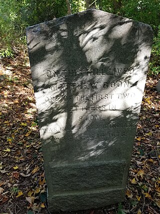
Matthew Boon was the first English settler in what is now Stow, Massachusetts. After his murder in 1676 by Native Americans, he became the namesake of what is now Lake Boon.

Summer Hill is a 351-foot (107 m) hill overlooking the Assabet River in Maynard, Massachusetts "with a gradual slope to the north and west". Today the hill is largely conservation land with 24 acres of public hiking trails, and the summit of hill also contains a radio tower and the town's steel and concrete water tanks. It is the highest point in Maynard.
"The Old Marlborough Road" is a poem written by Trascendentalist philosopher Henry David Thoreau in 1850.

Mount Misery is a 284-foot hill and public conservation land in Lincoln, Massachusetts, on Route 117 and on the Bay Circuit Trail near the Sudbury River. Containing 227 acres (92 ha), Mount Misery is the largest piece of conservation land in the town and contains seven miles of public hiking trails through hills, wetlands and agricultural fields.