
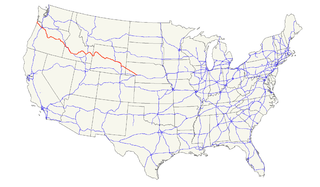
U.S. Route 101, or U.S. Highway 101 (US 101) is a north–south United States Numbered Highway that runs through the states of California, Oregon, and Washington, on the West Coast of the United States. It is also known as El Camino Real where its route along the southern and central California coast approximates the old trail which linked the Spanish missions, pueblos, and presidios. It merges at some points with California State Route 1 (SR 1).

U.S. Route 12 is an east–west United States highway, running from Aberdeen, Washington, to Detroit, Michigan, for almost 2,500 miles (4,000 km). As a thoroughfare, it has mostly been supplanted by I-90 and I-94, but remains an important road for local and regional travel.

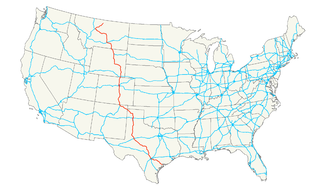
U.S. Route 30 or U.S. Highway 30 is an east–west main route in the system of the United States Numbered Highways, with the highway traveling across the northern tier of the country. With a length of 3,073 miles, it is the third longest U.S. highway, after U.S. Route 20 and U.S. Route 6. The western end of the highway is at US 101 in Astoria, Oregon; the eastern end is at Virginia Avenue, Absecon Boulevard, and Adriatic Avenue in Atlantic City, New Jersey. Despite long stretches of parallel and concurrent Interstate Highways, it has not been decommissioned unlike other long haul routes such as U.S. Route 66.
U.S. Route 26 is an east–west United States highway. It started in Ogallala, Nebraska, and was subsequently extended to the West Coast in Oregon. When the U.S. highway system was first defined, it was limited to Nebraska and Wyoming; by the 1950s, it continued into Idaho and Oregon. The highway's eastern terminus is in Ogallala, Nebraska at an intersection with Interstate 80. Its western terminus is south of Seaside, Oregon at an intersection with U.S. Route 101. Prior to 2004, the route's last 20 miles (32 km) were co-signed with U.S. Route 101 from the highways' junction south of Seaside north to Astoria where its intersection with U.S. Route 30 was also U.S. 30's western terminus.

U.S. Route 20 or U.S. Highway 20 (US 20) is an east–west United States highway that stretches from the Pacific Northwest all the way to New England. The "0" in its route number indicates that US 20 is a coast-to-coast route and major route. Spanning 3,365 miles (5,415 km), it is the longest road in the United States, and particularly from Newport, Oregon to Boston, Massachusetts, the route is roughly parallel to that of the newer Interstate 90 (I-90), which is in turn the longest Interstate Highway in the U.S.. There is a discontinuity in the official designation of US 20 through Yellowstone National Park, with unnumbered roads used to traverse the park.
U.S. Route 28 (US 28) is a defunct designation of an east–west highway that was located completely in the U.S. state of Oregon. It connected US 99 in Eugene with US 20 in Ontario.

U.S. Route 99 (US 99) was a main north–south United States Numbered Highway on the West Coast of the United States until 1964, running from Calexico, California, on the US–Mexico border to Blaine, Washington, on the U.S.-Canada border. It was assigned in 1926 and existed until it was replaced for the most part by Interstate 5. Known also as the "Golden State Highway" and "The Main Street of California", US 99 was important throughout much of the 1930s as a route for Dust Bowl immigrant farm workers to traverse the state. Large portions are now California's State Route 99 (SR 99), Oregon Route 99, 99W, 99E and Washington's SR 99. The highway connected to British Columbia Highway 99 at the Canada–US border.
U.S. Route 18 is an east–west U.S. highway in the Midwestern United States. The western terminus is in Orin, Wyoming at an interchange with Interstate 25. Its eastern terminus is in downtown Milwaukee, Wisconsin. However, US 18 runs concurrent with other U.S. routes from its western terminus to Mule Creek Junction, Wyoming.

U.S. Route 34 (US 34) is an east–west United States highway that runs for 1,122 miles (1,806 km) from north-central Colorado to the western suburbs of Chicago. Through Rocky Mountain National Park it is known as the Trail Ridge Road where it reaches elevation 12,183 feet (3,713 m), making it the highest paved through highway in the United States. The highway's western terminus is Granby, Colorado at US 40. Its eastern terminus is in Berwyn, Illinois at Illinois Route 43 and Historic US 66.
U.S. Highway 87 is a north–south United States highway that runs for 1,998 miles (3,215 km) from northern Montana to southern Texas. Most of the portion from Billings, Montana, to Raton, New Mexico, is co-signed along Interstates 90 and 25. It is also co-signed along the majority of Interstate 27 in Texas.

U.S. Route 101 (US 101), is a major north–south U.S. Highway in Oregon that runs through the state along the coastline near the Pacific Ocean. It runs from the California border, south of Brookings, to the Washington state line on the Columbia River, between Astoria, Oregon, and Megler, Washington.

In the U.S. state of Oregon, U.S. Route 30, a major east–west U.S. Highway, runs from its western terminus in Astoria to the Idaho border east of Ontario. West of Portland, US 30 generally follows the southern shore of the Columbia River; east of Portland the highway has largely been replaced with Interstate 84, though it is signed all the way across the state, and diverges from the I-84 mainline in several towns, as a de facto business route. Out of all the states U.S. Route 30 traverses, it spends the most time in Oregon.

State Route 401 (SR 401) is a 12.13-mile (19.52 km) long state highway in Pacific County within the U.S. state of Washington. The highway originates at the north end of the Astoria–Megler Bridge west of Megler at an intersection with U.S. Route 101 (US 101). The roadway travels northeast, paralleling cliffs, the Columbia River and the South Fork of the Naselle River to Naselle, ending at SR 4. The road was designated Secondary State Highway 12B (SSH 12) between 1937 and 1964, when SR 401 was created to replace SSH 12B. The Astoria–Megler Bridge, completed in 1966, replaced a ferry east of the bridge, where the highway originally ended, and is known locally as Kingston Ferry Road. The roadway was extended west to the north end of the bridge, where it currently terminates. The former ferry terminal became the Dismal Nitch rest area, named after the Lewis and Clark Expedition's description of the place.
Wyoming Highway 220 is the principal highway connecting the city of Casper to US 287/WYO 789. WYO 220 lies in northwestern Carbon and southern Natrona counties and along the famous Oregon Trail.
Interstate 25 (I-25) is a part of the Interstate Highway System that runs from Las Cruces, New Mexico, to Buffalo, Wyoming. In Wyoming, the Interstate Highway runs 300.530 miles (483.656 km) from the Colorado state line near Cheyenne north to its national terminus at I-90 near Buffalo. I-25 connects Wyoming's largest city and capital, Cheyenne, with its second largest city, Casper, and the smaller communities of Wheatland, Douglas, and Buffalo. The highway also connects those cities with Denver and Billings via I-90. I-25 runs concurrently with U.S. Route 87 for almost its entire course in Wyoming. The highway also has extensive concurrencies with US 20 and US 26 along its east–west segment through the North Platte River valley. The Interstate has business loops through Cheyenne, Chugwater, Wheatland, Douglas, Glenrock, Casper, and Buffalo.

U.S. Highway 26 (US‑26) is an east–west highway in western Nebraska. It enters the state from Wyoming just west of Henry. The eastern terminus of US‑26 is in Ogallala at an interchange with Interstate 80 (Nebraska) (I-80). The highway largely parallels the North Platte River for the majority of its route in Nebraska and as such, runs at a northwest-southeast angle. The highway also parallels the original paths of the Oregon Trail, the California Trail and the Mormon Pioneer Trail.
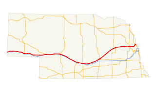
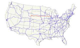
U.S. Highway 30 (US 30) is part of the United States Numbered Highway System that runs for 3,073 miles (4,946 km) from Astoria, Oregon to Atlantic City, New Jersey. Within the state of Nebraska it is a state highway that travels 451.74 miles (727.01 km) west to east across the state from the Wyoming state line west of Bushnell to the Missouri River in Blair on the Iowa state line. For much of its length it travels within the Platte River valley, adjacent or near the river between Brule and Fremont, a distance of just over 300 miles (480 km). This corridor was also highly traveled during Westward Expansion along the California and Oregon Trails, it was also used by the Pony Express and the Transcontinental Railroad. The landscape is dominated by vast agricultural fields within the fertile Platte River valley across the center of the state, while the western portion passes through higher plains and the eastern portion through the rolling hills adjacent to the Missouri River valley.

U.S. Route 26 (US-26) is a major cross-state United States highway with its western terminus in the U.S. state of Oregon, connecting U.S. Route 101 on the Oregon Coast near Seaside with the Idaho state line east of Nyssa. Local highway names include the Sunset Highway No. 47, Mount Hood Highway No. 26, and John Day Highway No. 5 before continuing into Idaho and beyond.
Wyoming Highway 387 is a state road that travels from extreme northeast Natrona County, Wyoming through extreme southeast Johnson County, Wyoming and into southwest Campbell County, Wyoming.
Wyoming Highway 320 (WYO 320) is a 12.33-mile-long (19.84 km) north–south state highway in central Platte County, Wyoming that connects Interstate 25 Business and U.S. Route 87 Business in Wheatland to US 26 in Dwyer, and was once part of the Yellowstone Highway.


