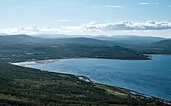
Village | |
Coordinates: 70°28′25″N25°04′16″E / 70.47361°N 25.07111°E | |
Country | Norway |
Region | Northern Norway |
County | Finnmark |
District | Vest-Finnmark |
Municipality | Porsanger |
Elevation | 5 m (16 ft) |
Time zone | UTC+01:00 (CET) |
• Summer (DST) | UTC+02:00 (CEST) |
Post Code | 9713 Russenes |
Olderfjord (Norwegian), Leaibevuotna (Northern Sami), or Leipovuono (Kven) [2] is a village in Porsanger Municipality in Finnmark county, Norway. The village lies at the end of Olderfjorden on the eastern coast of the Porsanger Peninsula, along the shore of the Porsangerfjorden.
The village sits at the junction of the European route E6 and European route E69 highways, about 10 kilometres (6.2 mi) northwest of the smaller village of Kistrand, where the historic Kistrand Church is located. In terms of its longitude, Olderfjord is located further east than any location in Sweden and just east of Helsinki. Being well above 70°N, there is a prolonged midnight sun and polar night in the village.
The village hosts a tourist centre with hotel rooms and apartments, a camping site and a cafeteria.
Nordkapp is a municipality in Finnmark county, Norway. The administrative centre of the municipality is the town of Honningsvåg, where most residents live. Other settlements in Nordkapp include the villages of Gjesvær, Kåfjord, Kamøyvær, Kjelvik, Nordvågen, Repvåg, Skarsvåg, and Valan.
Porsanger is a municipality in Finnmark county, Norway. The administrative centre of the municipality is the village of Lakselv. Other villages in the municipality include Børselv, Brenna, Indre Billefjord, Kistrand, Olderfjord, and Skoganvarre.
The Garrison of Porsanger, is a garrison based at Porsangmoen in Porsanger Municipality, in Finnmark county, Norway. It is located about 18 kilometres (11 mi) from the village of Lakselv. The garrison is located immediately adjacent to Halkavarre, the largest military training area in Norway.
Magerøya (Norwegian) or Máhkarávju (Northern Sami) is a large island in Finnmark county, in the extreme northern part of Norway. The island lies along the Barents Sea in Nordkapp Municipality, just north of the Porsanger Peninsula. The mouth of Porsangerfjorden lies off the east coast of the island.
, Leavdnja (Northern Sami) or Lemmijoki (Kven) is the largest village and administrative centre of Porsanger Municipality in Finnmark county, Norway. The village lies at the southern end of the large Porsangerfjorden. The 2.36-square-kilometre (580-acre) village has a population (2023) of 2,224 which gives the village a population density of 942 inhabitants per square kilometre (2,440/sq mi).
European route E69 is an E-road between Olderfjord and North Cape in northern Norway. The road is 129 km (80 mi) long. It contains five tunnels, totalling 15.5 km (9.6 mi). The longest, the North Cape Tunnel, is 6.9 km (4.3 mi) long and reaches 212 m (696 ft) below sea level.
Kistrand (Norwegian), Čuđegieddi (Northern Sami), or Ryssämarkka (Kven) is a village in Porsanger Municipality in Finnmark county, Norway. It is located on the eastern side of the Porsanger Peninsula, along the western shore of the Porsangerfjorden. The village lies along the European route E06 highway, about 10 kilometres (6.2 mi) southeast of the village of Olderfjord.
Børselv (Norwegian), Bissojohka (Northern Sami), or Pyssyjoki (Kven) is a village in Porsanger Municipality in Finnmark county, Norway. It is located at the base of the Sværholt Peninsula, along the east side of the Porsangerfjorden, at the outlet of the river Børselva. The village of Brenna lies about 30 kilometres (19 mi) to the north and about 40 kilometres (25 mi) northeast of the municipal centre of Lakselv.
Station Group Banak, formerly Banak Air Station, is a military airbase located at Banak, just north of Lakselv in Porsanger Municipality in Finnmark, Norway. Operated by the Royal Norwegian Air Force (RNoAF), it serves a detachment of the 330 Squadron, which operates two Westland Sea King helicopters used for search and rescue operations in Finnmark, Svalbard and surrounding Arctic sea areas. Of the station's two helicopters, one is on standby at any given time. The station group is co-located with the civilian Lakselv Airport, Banak and is administratively under the 132nd Air Wing and Bodø Main Air Station. Banak is RNoAF's most northerly base and has fifty employees.
Kjæsvannet is a lake on the border of Porsanger Municipality and Lebesby Municipality in Finnmark county, Norway. The 5.16-square-kilometre (1.99 sq mi) lake is located on the Sværholt Peninsula, about half-way between the villages of Veidnes and Brenna.
Kåfjord is a small village in Nordkapp Municipality in Finnmark county, Norway. It is located on the Porsanger Peninsula, along the Kåfjorden, an arm off of the main Porsangerfjorden.
The Porsangerfjorden is a fjord in Finnmark county, Norway.
Lakselva is a river in Finnmark county in northern Norway. It begins in Karasjok Municipality runs north through Porsanger Municipality into the Porsangerfjorden, a fjord off of the Barents Sea. The 103-kilometre (64 mi) long river runs past the village of Lakselv. The European route E06 highway runs along the river for much of its course. The river is famous for its Atlantic salmon fishing.
Gákkajávri (Northern Sami) or Gaggavann (Norwegian) is a lake that lies in Porsanger Municipality in Finnmark county, Norway. The 7.4-square-kilometre (2.9 sq mi) lake lies just east of the European route E06 highway, between the villages of Lakselv and Karasjok.
The Porsanger Peninsula is a peninsula in Finnmark county, Norway. The large peninsula sits between the Altafjorden and the Porsangerfjorden and includes parts of the municipalities of Alta, Hammerfest, Måsøy, Nordkapp, and Porsanger. Stabbursdalen National Park lies on the southern end of the peninsula.
Kåfjorden is a fjord in Nordkapp Municipality in Finnmark county, Norway. The 4.5-kilometre (2.8 mi) long fjord is located on the Porsanger Peninsula and it flows past the village of Kåfjord. It is located about 12 kilometres (7.5 mi) southeast of the town of Honningsvåg. The fjord flows out into the Magerøysundet strait and then into the Porsangerfjorden. The European route E69 highway follows the southern coast of the fjord, and the entrance to the North Cape Tunnel lies on the western coast of the fjord.
Lakselv Church is a parish church of the Church of Norway in Porsanger Municipality in Finnmark county, Norway. It is located in the village of Lakselv. It is one of the churches for the Porsanger parish which is part of the Indre Finnmark prosti (deanery) in the Diocese of Nord-Hålogaland. The white, wooden church was built in a long church style in 1963 using plans drawn up by the architect Eyvind Moestue. The church seats about 400 people.
Kistrand Church is a parish church of the Church of Norway in Porsanger Municipality in Finnmark county, Norway. It is located in the village of Kistrand. It is the main church for the Porsanger parish which is part of the Indre Finnmark prosti (deanery) in the Diocese of Nord-Hålogaland. The white, wooden church was built in a long church style in 1856 using plans drawn up by the architect Christian Heinrich Grosch. The church seats about 160 people.
Skoganvarre (Norwegian), Skuvvanvárri (Northern Sami), or Skuukanvaara (Kven) is a village in Porsanger Municipality in Finnmark county, Norway. The village is located along the Lakselva river and the European route E06 highway, about half-way between the villages of Lakselv and Karasjok. The lake Gákkajávri lies just east of the village. The village is an old settlement, located on old roads crossing Finnmark. The Skoganvarre Chapel is located in the village.