Related Research Articles

The Samoan Islands are an archipelago covering 3,030 km2 (1,170 sq mi) in the central South Pacific, forming part of Polynesia and of the wider region of Oceania. Administratively, the archipelago comprises all of the Independent State of Samoa and most of American Samoa. The land masses of the two Samoan jurisdictions are separated by 64 km (40 mi) of ocean at their closest points.
The National Park of American Samoa is a national park in the United States territory of American Samoa, distributed across three islands: Tutuila, Ofu, and Ta‘ū. The park preserves and protects coral reefs, tropical rainforests, fruit bats, and the Samoan culture. Popular activities include hiking and snorkeling. Of the park's 8,257 acres (3,341 ha), 2,500 acres (1,000 ha) is coral reefs and ocean. The park is the only American National Park Service system unit south of the equator.

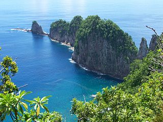
Taʻū is the largest island in the Manuʻa Group and the easternmost volcanic island of the Samoan Islands. Taʻū is part of American Samoa. In the early 19th century, the island was sometimes called Opoun.
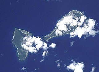
Ofu and Olosega are parts of a volcanic doublet in the Manu‘a Island Group, which is part of American Samoa in the Samoan Islands. These twin islands, formed from shield volcanoes, have a combined length of 6 km and a combined area of 12 square kilometers. Together, they have a population of about 500 people. Geographically, the islands are volcanic remnants separated by the narrow, 137-meter-wide (449-foot)) Āsaga Strait, composed of shallow-water coral reef. Before 1970, people crossed between the two islands by waiting until low tide and then wading across the shallow water of the strait. Since 1970, there has been a bridge over the strait, providing a single-lane road that connects the two islands.

The Manuʻa Islands, or the Manuʻa tele, in the Samoan Islands, consists of three main islands: Taʻū, Ofu and Olosega. The latter two are separated only by the shallow, 137-meter-wide Āsaga Strait, and are now connected by a bridge over the strait. The islands are located some 110 kilometers east of Tutuila and are a part of American Samoa, an unincorporated territory of the United States. Their combined area is 56 square kilometers, and they have a total population of 1,400. Taʻu is the largest of these islands, with an area of 44 km2 (17 sq mi), and it has the highest point of the Manuʻa, at 931 meters. Politically, the islands form the Manuʻa District, one of the three administrative divisions of American Samoa.

The American Samoa Fono is the territorial legislature of American Samoa. Like most state and territorial legislatures of the United States, it is a bicameral legislature with a House of Representatives and a Senate. The legislature is located in Fagatogo along Pago Pago harbor.
The American Samoa House of Representatives is the lower house of the American Samoa Fono. The House consists of 21 members serving two-year terms, with 20 popularly elected representatives, and one delegate from Swains Island elected in a public meeting.
The American Samoa Senate is the upper house of the American Samoa Fono. The Senate, like the lower House of Representatives, is a nonpartisan body. It is composed of 18 senators, serving a four-year term.
Fagali'i or Fagali'i-uta is a village on the island of Upolu in the Samoa archipelago approximately 5 kilometres south-east of Apia. It is in the electoral constituency of Vaimauga East which forms part of the larger political district of Tuamasaga.

The following outline is provided as an overview of and topical guide to American Samoa:
Velega Savali Savali Jr. is an American Samoan politician. Savali was a candidate for Lieutenant Governor of American Samoa in the American Samoan gubernatorial election in 2008. He served as the American Samoa Treasurer from 2005 until 2008, and a senator from 2009 to 2012.
Olosega may refer to one of multiple places in American Samoa:

The Manuʻa District is one of the three primary administrative divisions of American Samoa. The district comprises the Manuʻa Islands, which are located approximately 61 miles east of the main island, Tutuila. The Manuʻa District is considered to be a county-equivalent by the U.S. Census Bureau.
Lalomoana is a small settlement located in Olosega island in Ofu-Olosega on the slopes on Piumafua, in Manu‘a Group of the Samoan Islands—part of American Samoa. No roads connect to the settlement.
Sili is a tiny village on the island of Olosega on Ofu-Olosega. Sili, situated on the northwestern-facing shore, in the present day consists of but one standing inhabited residence after much of the village was destroyed by cyclones. Its closest place is Lalomoana.
Faiava is a tribal settlement on the island of Olosega on Ofu-Olosega
Ofu County is a county in the Manu'a District in American Samoa. It was the result of the subdivision of the prior Luanuu County in two, with the other newly created county being Olosega, first reported on the 1930 U.S. Census. It is now contiguous with its only village, Ofu.
Olosega County is a county in the Manu'a District in American Samoa. It was the result of the subdivision of the prior Luanuu County in two, with the other newly created county being Ofu, first reported on the 1930 U.S. Census. It contains the two villages of Olosega and Sili.
Luanuu County is a former county in the Manu'a District in American Samoa. It reported on the 1912 special census and the 1920 U.S. Census. It was subdivided into the present Ofu and Olosega Counties in 1930. It contained the villages of Ofu, Olosega and Sili.
References
- ↑ "Ofu-Olosega".
- ↑ "Olosega · Manu'a, American Samoa".
- ↑ Hills, J.W. (2010). O upu muamua i le Tala i le Lalolagi mo e ua faatoa a'oa'oina u lea mataupu: Elementary Geography. Nabu Press. Page 64. ISBN 9781147952896.
- ↑ as.geoview.info/olosega_elementary_school,5881559
Coordinates: 14°10′38″S169°37′22″W / 14.177183°S 169.622839°W
| | This American Samoa–related article is a stub. You can help Wikipedia by expanding it. |