Olta | |
|---|---|
Municipality and village | |
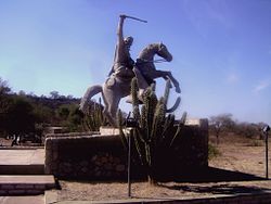 Monument of Chacho Peñaloza, at the north entrance of Olta | |
| Country | |
| Province | La Rioja Province |
| Time zone | UTC−3 (ART) |
| Climate | BSh |
Olta is a municipality and village in La Rioja Province in northwestern Argentina. [1]
Olta | |
|---|---|
Municipality and village | |
| Monument of Chacho Peñaloza, at the north entrance of Olta | |
| Country | |
| Province | La Rioja Province |
| Time zone | UTC−3 (ART) |
| Climate | BSh |
Olta is a municipality and village in La Rioja Province in northwestern Argentina. [1]

The Arctic Archipelago, also known as the Canadian Arctic Archipelago, is an archipelago lying to the north of the Canadian continental mainland, excluding Greenland and Iceland.
Cudgegong River, a perennial stream that is part of the Macquarie catchment within the Murray–Darling basin, is located in the central western and Orana districts of New South Wales, Australia.
The Alexandra Mountains are a group of low, separated mountains in the north portion of Edward VII Peninsula, just southwest of Sulzberger Bay in Marie Byrd Land, Antarctica.
The Deep Freeze Range is a rugged mountain range, over 80 nautical miles long and about 10 nautical miles wide, rising between Priestley and Campbell Glaciers in Victoria Land, Antarctica, and extending from the edge of the polar plateau to Terra Nova Bay. It is southwest of the Southern Cross Mountains, south of the Mesa Range and northeast of the Eisenhower Range of the Prince Albert Mountains.
The Behrendt Mountains is a group of mountains, 20 nautical miles long, aligned in the form of a horseshoe with the opening to the southwest, standing 7 nautical miles southwest of the Merrick Mountains in Ellsworth Land, Antarctica.

Tomás Barrón is a province in the northern parts of the Bolivian department of Oruro.

The Prince Charles Mountains are a major group of mountains in Mac. Robertson Land in Antarctica, including the Athos Range, the Porthos Range, and the Aramis Range. The highest peak is Mount Menzies, with a height of 3,228 m (10,591 ft). Other prominent peaks are Mount Izabelle and Mount Stinear. These mountains, together with other scattered peaks, form an arc about 420 km (260 mi) long, extending from the vicinity of Mount Starlight in the north to Goodspeed Nunataks in the south.

Liédena is a town and municipality located in the province and autonomous community of Navarre, northern Spain.

Mirafuentes is a town and municipality located in the province and autonomous community of Navarre, northern Spain.

Llano de Olmedo is a municipality located in the province of Valladolid, Castile and León, Spain. According to the 2004 census (INE), the municipality had a population of 82 inhabitants.
Sillard Islands is a group of small ice-covered islands lying close to Cape Mascart, the northeast extremity of Adelaide Island. Discovered by the French Antarctic Expedition, 1908–10, under Charcot, and named for Director Sillard of the French Montevideo Co., Montevideo, Uruguay, whose company made repairs on Charcot's ship, the Pourquoi Pas ?.
Tucumanao is a village and municipality in Catamarca Province in northwestern Argentina.

Bader Glacier is a small glacier draining the west slopes of Rudozem Heights and flowing to Bourgeois Fjord just south of Thomson Head on German Peninsula, Fallières Coast on the west side of Graham Land, Antarctica.
Charpentier Pyramid is a pyramid-shaped peak rising to 1,080 metres (3,540 ft) in the northwest part of the Herbert Mountains, Shackleton Range. In association with the names of glacial geologists grouped in this area, it was named by the UK Antarctic Place-Names Committee in 1971 after Jean de Charpentier, a Swiss engineer and mineralogist who in 1835 gave additional proof on the former extension of glaciers.
Meridian Glacier is a broad glacier, 9 nautical miles (17 km) long, which flows south along the west side of Godfrey Upland and joins Clarke Glacier between Behaim Peak and Elton Hill, in southern Graham Land, Antarctica. Finn Ronne and Carl R. Eklund of the United States Antarctic Service travelled along this glacier in January 1941. It was photographed from the air by the Ronne Antarctic Research Expedition in November 1947, and was surveyed by the Falkland Islands Dependencies Survey in December 1958. The glacier was so named by the UK Antarctic Place-Names Committee because the glacier flows from north to south along the meridian.
Rigsby Islands is a small group of ice-capped islands lying off the northeast coast of Adelaide Island, about 2 nautical miles (3.7 km) south of Sillard Islands. Mapped from air photos taken by Ronne Antarctic Research Expedition (RARE) (1947–48) and Falkland Islands and Dependencies Aerial Survey Expedition (FIDASE) (1956–57). Named by United Kingdom Antarctic Place-Names Committee (UK-APC) for George P. Rigsby, American geologist who has specialized in the investigation of ice crystal structure and the plasticity of ice.
Banco San Miguel is a neighbourhood (barrio) of Asunción, Paraguay.
Virgen de la Asunción is a neighbourhood (barrio) of Asunción, Paraguay.
Bañado de Santa Ana is a neighbourhood (barrio) of Asunción, Paraguay.
30°37′S66°16′W / 30.617°S 66.267°W
| | This article about a place in La Rioja Province, Argentina is a stub. You can help Wikipedia by expanding it. |