Related Research Articles

Vice-Admiral William Bligh was a British officer in the Royal Navy and a colonial administrator. He is best known for the mutiny on HMS Bounty, which occurred in 1789 when the ship was under his command. The reasons behind the mutiny continue to be debated. After being set adrift in Bounty's launch by the mutineers, Bligh and those loyal to him stopped for supplies on Tofua, losing a man to natives. Bligh and his men reached Timor alive, after a journey of 3,618 nautical miles.

The maritime European exploration of Australia consisted of several waves of European seafarers who sailed the edges of the Australian continent. Dutch navigators were the first Europeans known to have explored and mapped the Australian coastline. The first documented encounter was that of Dutch navigator Willem Janszoon, in 1606. Dutch seafarers also visited the west and north coasts of the continent, as did French explorers.
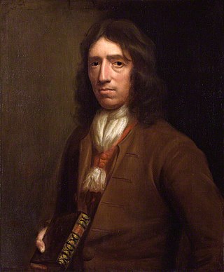
William Dampier was an English explorer, pirate, privateer, navigator, and naturalist who became the first Englishman to explore parts of what is today Australia, and the first person to circumnavigate the world three times. He has also been described as Australia's first natural historian, as well as one of the most important British explorers of the period between Sir Francis Drake and Captain James Cook ; he "bridged those two eras" with a mix of piratical derring-do of the former and scientific inquiry of the latter. His expeditions were among the first to identify and name a number of plants, animals, foods, and cooking techniques for a European audience, being among the first English writers to use words such as avocado, barbecue, and chopsticks. In describing the preparation of avocados, he was the first European to describe the making of guacamole, named the breadfruit plant, and made frequent documentation of the taste of numerous foods foreign to the European palate at the time, such as flamingo and manatee.

Willem Hesselsz de Vlamingh was a Dutch sea captain who explored the central west coast of New Holland (Australia) in the late 17th century, where he landed in what is now Perth on the Swan River. The mission proved fruitless, but he charted parts of the continent's western coast.
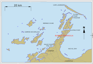
Dampier is a major industrial port in the Pilbara region in the northwest of Western Australia. It is located near the city of Karratha and Port Walcott.

Pepys Island is a phantom island, once said to lie about 230 nautical miles north of the Falkland Islands at 47°S. Pepys Island is now believed to have been a misidentified account of the Falkland Islands.

Woodes Rogers was an English sea captain, privateer, slave trader and, from 1718, the first Royal Governor of the Bahamas. He is remembered as the captain of the vessel that rescued marooned Alexander Selkirk, whose plight is generally believed to have inspired Daniel Defoe's Robinson Crusoe.
William Wright was an English privateer in French service and later buccaneer who raided Spanish towns in the late 17th century.

New Holland is a historical European name for mainland Australia.

Cape Horn is the southernmost headland of the Tierra del Fuego archipelago of southern Chile, and is located on the small Hornos Island. Although not the most southerly point of South America, Cape Horn marks the northern boundary of the Drake Passage and marks where the Atlantic and Pacific Oceans meet.

Tryal Rocks, sometimes spelled Trial Rocks or Tryall Rocks, formerly known as Ritchie's Reef or Greyhound's Shoal, is a reef of rock located in the Indian Ocean off the northwest coast of Australia, 14 kilometres (8.7 mi) northwest of the outer edge of the Montebello Islands group. It is named for the Tryall, the first known shipwreck in Australian waters, which sank after striking the then-uncharted rocks in 1622. Described as "the theme and dread of every voyager to the eastern islands", their location was sought for over three centuries before finally being determined in 1969.

HMS Roebuck was a fifth-rate warship in the Royal Navy which, under the command of William Dampier, carried the first British scientific expedition to Australia in 1699. The wreck of the ship has since been located by a team from the Western Australian Maritime Museum at a site on the coast of Ascension Island where it foundered more than 300 years ago.

The first voyage of James Cook was a combined Royal Navy and Royal Society expedition to the south Pacific Ocean aboard HMS Endeavour, from 1768 to 1771. It was the first of three Pacific voyages of which James Cook was the commander. The aims of this first expedition were to observe the 1769 transit of Venus across the Sun, and to seek evidence of the postulated Terra Australis Incognita or "undiscovered southern land".

Dampier Strait in Papua New Guinea separates Umboi Island and New Britain, linking the Bismarck Sea to the north with the deeper Solomon Sea to the south.

William Ambrosia Cowley, also known as Ambrose Cowley and Captain Cowley, was a 17th-century English buccaneer who surveyed the Galápagos Islands during his 1683–1686 circumnavigation of the world while serving under several captains such as John Eaton, John Cook, and later Edward Davis. Cowley drafted the first chart of the islands in 1684, first published with the account of his voyage in 1699. In his diary he reported the discovery of the phantom Pepys Island, allegedly situated north of the Falkland Islands, prompting a number of mariners to look in vain for the nonexistent rock.
Abraham Bristow (c1771-1846) was a British mariner, sealer and whaler. In August 1806 he discovered the Auckland Islands.
Early Polynesian explorers reached nearly all Pacific islands by 1200 CE, followed by Asian navigation in Southeast Asia and the West Pacific. During the Middle Ages, Muslim traders linked the Middle East and East Africa to the Asian Pacific coasts, reaching southern China and much of the Malay Archipelago. Direct European contact with the Pacific began in 1512, with the Portuguese encountering its western edges, soon followed by the Spanish arriving from the American coast.
Rosemary Island is an island in the Dampier Archipelago in the Pilbara region of Western Australia. With Enderby Island it forms Class A Nature Reserve 36915, part of a proposed national park.

The Mauritius was an early 17th century Dutch wooden-hulled sailing ship, documented as being in service to the Dutch East India Company between 1618 and 1622.
Iris was launched in France in 1794 and came into British hands in 1803, probably by purchase. She became a whaler in the British southern whale fishery. In 1805 she made an unsuccessful attack on a Batavian vessel. Iris was condemned as unseaworthy in late 1805 on her way home after her first voyage as a whaler.
References
- ↑ Dampier, William (1699). "A Continuation of a Voyage to New Holland" . Retrieved April 7, 2022.
- ↑ "Ship News", Sydney Gazette and New South Wales Advertiser 13 October 1805, p. 2.
| | This Indonesia location article is a stub. You can help Wikipedia by expanding it. |