| Ometepec River | |
|---|---|
 Location of mouth | |
| Location | |
| Country | Mexico |
| State | Guerrero |
| Physical characteristics | |
| Mouth | |
• coordinates | 16°32′57″N98°35′02″W / 16.54913°N 98.58382°W Coordinates: 16°32′57″N98°35′02″W / 16.54913°N 98.58382°W |
| Ometepec River | |
|---|---|
| Location of mouth | |
| Location | |
| Country | Mexico |
| State | Guerrero |
| Physical characteristics | |
| Mouth | |
• coordinates | 16°32′57″N98°35′02″W / 16.54913°N 98.58382°W Coordinates: 16°32′57″N98°35′02″W / 16.54913°N 98.58382°W |

The Pecos River originates in north-central New Mexico and flows into Texas, emptying into the Rio Grande. Its headwaters are on the eastern slope of the Sangre de Cristo mountain range in Mora County north of Pecos, NM, at an elevation of over 12,000 feet (3,700 m) feet. The river flows for 926 miles (1,490 km) before reaching the Rio Grande near Del Rio. Its drainage basin encompasses about 44,300 square miles (115,000 km2).

Ricardo Antonio La Volpe Guarchoni is an Argentine former professional footballer and manager. He is a World Cup-winning goalkeeper who played for most of his career in Argentina and Mexico.

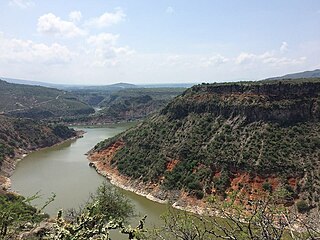
The Costa Chica of Guerrero is an area along the south coast of the state of Guerrero, Mexico, extending from just south of Acapulco to the Oaxaca border. Geographically, it consists of part of the Sierra Madre del Sur, a strip of rolling hills that lowers to coastal plains to the Pacific Ocean. Various rivers here form large estuaries and lagoons that host various species of commercial fish.

Ometepec is one of the 81 municipalities of Guerrero, in south-western Mexico. The municipal seat lies at Ometepec. The municipality covers an area of 1,100.6 km².
Xochistlahuaca Municipality is one of the 81 municipalities of Guerrero, in south-western Mexico. The municipal seat lies at Xochistlahuaca. The municipality covers an area of 321.1 km².
Ometepec is a city and the seat of the municipality of Ometepec, in the state of Guerrero, south-western Mexico.
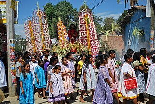
Xochistlahuaca is a town in Xochistlahuaca Municipality located in the southeast corner of the Mexican state of Guerrero. It is part of this state's Costa Chica region and while near the Pacific Ocean, most of the territory is mountainous. The population is dominated by the indigenous Amuzgo ethnicity, whose women are noted for their traditional hand woven garments, especially the huipil, which is made both for home use and for sale outside the area.

The Cazones River is a river of Mexico.

The SabinasRiver is a river of Mexico. It is a tributary of the Rio Salado, which in turn flows into the Rio Grande.
Río Verde,, is a river of San Luis Potosí state in eastern Mexico.
The Moctezuma River is a river in Mexico that drains the eastern side of the Trans-Mexican Volcanic Belt. It is a tributary of the Pánuco River and flows through the Mexican states of Hidalgo, Querétaro, and San Luis Potosí.
The Lacantún River is a river of Mexico.
The Jataté River is a river of Chiapas, Mexico. The river runs through a canyon and is a jade-green color.
The Cutzamala River is a river of Mexico.

The 2012 Guerrero–Oaxaca earthquake struck southern Mexico with a moment magnitude of 7.4 at 12:02 local time on Tuesday, 20 March. Its epicenter was near Ometepec, in the border between the states of Guerrero and Oaxaca. With a shallow focus of 15 to 20 km, the earthquake caused strong shaking over a large area along the Oaxaca–Guerrero border and the adjacent Pacific coastline. Significant tremors were felt in areas up to several hundred kilometers away, including Mexico City and also in Guatemala. Two people were killed and over 30,000 houses were damaged or destroyed.
Central Nahuatl is a group of Nahuatl languages of central Mexico, in the regions of central Puebla, Tlaxcala, central Veracruz, Morelos, Mexico State, and Guerrero.
Ometepec Nahuatl, also known as Southern Guerrero Nahuatl, is one of the Central Nahuatl languages of south-central Mexico. The dialects of the three areas where Ometepec Nahuatl is spoken are distinct enough to potentially be considered separate languages.
The Amuzgos are an indigenous people of Mexico. They primarily live in a region along the Guerrero/Oaxaca state border, chiefly in or near four municipalities: Xochistlahuaca, Tlacoachistlahuaca and Ometepec in Guerrero, and San Pedro Amuzgos in Oaxaca. The origin of the Amuzgos is not known, but their Amuzgo language is similar to the Mixtec language and their territory overlaps that of the Mixtec region. In the past, they dominated a larger area, but Mixtec domination, followed by the Spanish and the arrival of Afro-Mexicans pushed them into the more inaccessible mountain regions and away from the coast. The Amuzgos maintain much of their language and dress and are known for their textiles handwoven on backstrap looms with two-dimensional designs which can be complicated. The Amuzgo area is very poor with an economy mostly dependent on subsistence agriculture and handcraft production.
The 1982 Ometepec earthquake that struck Mexico's southwestern coast near Ometepec (Guerrero) on 7 June was a doublet earthquake that ruptured in two steps. The first happened at 06:52 UTC, the second five hours later at 10:59 UTC. Estimated magnitudes are 6.9 and 7.0 on the Ms scale, and 5.8 and 6.0 on the mb scale. The maximum MM intensities were VII and VIII, respectively.
| | This article related to a river in Mexico is a stub. You can help Wikipedia by expanding it. |