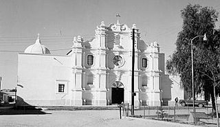
Huatabampo is a city in Huatabampo Municipality in the state of Sonora, in northwestern Mexico. It is situated on the Gulf of California, near the mouth of the Mayo River. It is located at latitude 26°49′N109°40′W. Huatabampo is 34 km southwest of Navojoa via Sonora State Highway 56 and Sonora State Highway 149. Mexican Federal Highway 15 can be accessed via Sonora State Highway 176. It is notable as the home of revolutionary general Álvaro Obregón, a successful chickpea farmer before the Mexican Revolution, and now his burial site.

Arivechi is a town in Arivechi Municipality in the Mexican state of Sonora. It is located in the east of Sonora at 28°55'"N 109°11'"W, at an elevation of 556 meters.
Bacanora is a small town in Bacanora Municipality in the east of the Mexican state of Sonora. It is located at the geographical coordinates of 28°59′N109°24′W.

Bacoachi is a small town in Bacoachi Municipality in the north of the Mexican state of Sonora. The area of the municipality is 487 square miles (1,260.65 km²) and the population was 1,456 in 2005, with 924 inhabitants residing in the municipal seat. The elevation of the municipal seat is 4,429 feet above sea level.
Divisaderos the municipal seat of Divisaderos Municipality of the Mexican state of Sonora. It is located at 29°36′N109°28′W, about 20 mi/30 km SE of Moctezuma. Access is by an unpaved road to Moctezuma and Sahuaripa. Almost all he inhabitants live in the municipal seat, which lies at an elevation of 850 m.

Fronteras is the seat of Fronteras Municipality in the northeastern part of the Mexican state of Sonora. Frontera translates as Border. The elevation is 1,120 meters and neighboring municipalities are Agua Prieta, Nacozari and Bacoachi. The area is 2839.62 km², which represents 1.53% of the state total.
Huásabas is the municipal seat of Huásabas Municipality in the northeast of the Mexican state of Sonora. The municipal area is 711.17 km² (274.58 mi²) with a population of 966 registered in 2000. Most of the inhabitants live in the municipal seat.

Moctezuma is a municipio (municipality) of the Mexican state of Sonora, located in the state's central region. It is also the name of its largest settlement and cabecera municipal.
Nacozari de García is a small mining town surrounded by Nacozari de García Municipality in the northeast of the Mexican state of Sonora.
Tepache is a small town in Tepache Municipality in the east of the Mexican state of Sonora. Its location by GPS coordinates is at: Longitude (dec): -109.528889; Latitude (dec): 29.533333.

Quiriego is a small town and the county seat of the Municipality of Quiriego, located in the southeast of the Mexican state of Sonora.
Rosario de Tesopaco is a small town, the seat of Rosario de Tesopaco Municipality in the southeast of the Mexican state of Sonora.

Yécora is a small town, and its surrounding municipality of the same name, in the Mexican state of Sonora, located at Latitude = 28.3710, Longitude = -108.9269 with an elevation of 5,173 feet. The town is bordered on the east by the state of Chihuahua, to the north by the municipalities of Sahuaripa and Southeast Rosario, to the west by the municipality Suaqui Grande, and the northwest by the municipality of Onavas. Yécora has an area of 1,279 square miles, accounting for 1.79 percent of total state. An approximate population for Yécora is 317.
San Pedro de la Cueva is a town in San Pedro de la Cueva Municipality, in the Mexican state of Sonora. It is located in the center of the state at an elevation of 500 meters.
Soyopa is a town in Soyopa Municipality, in the eastern region of the Mexican state of Sonora. The elevation is 350 meters.
Suaqui Grande is a town in Suaqui Grande Municipality, in the eastern region of the Mexican state of Sonora. It was founded in 1620 by the missionary Martín Burgencio.
Villa Hidalgo Municipality is a municipality, in the north-east of the Mexican state of Sonora.
Navojoa Municipality is a municipality in Sonora in north-western Mexico. As of 2015, the municipality had a total population of 163,650.
Rosario de Tesopaco Municipality is a municipality in Sonora in north-western Mexico.


