Related Research Articles

Onkaparinga River National Park is a protected area in the Australian state of South Australia located about 32 kilometres (20 mi) south of Adelaide city centre. It extends over the floodplain of the Onkaparinga River east of Main South Road.

The Division of Kingston is an Australian Electoral Division in South Australia covering the outer southern suburbs of Adelaide. The 171 km² seat stretches from Hallett Cove and O'Halloran Hill in the north to Sellicks Beach in the south, including the suburbs of Aberfoyle Park, Aldinga Beach, Christie Downs, Christies Beach, Flagstaff Hill, Hackham, Hallett Cove, Huntfield Heights, Lonsdale, Maslin Beach, Moana, Morphett Vale, Old Noarlunga, Onkaparinga Hills, Port Noarlunga, Reynella, Seaford, Sellicks Beach, Sheidow Park, Port Willunga, Trott Park, Woodcroft, and parts of Happy Valley and McLaren Flat.

Onkaparinga River Recreation Park is a protected area occupying land in the estuary of the Onkaparinga River in South Australia. The recreation park which was established in 1985 is approximately 32 km (20 mi) from Adelaide city centre. It is the venue for recreational activities such as walking, canoeing, kayaking, recreational fishing and picnics.

The City of Onkaparinga is a local government area (LGA) located on the southern fringe of Adelaide, South Australia. It is named after the Onkaparinga River, whose name comes from Ngangkiparinga, a Kaurna word meaning women's river. It is the largest LGA in South Australia, with a population of over 170,000 people in both urban and rural communities and is also geographically expansive, encompassing an area of 518.3 km². The council is headquartered in the Noarlunga Centre with area offices situated in Aberfoyle Park, Woodcroft and Willunga.
The Onkaparinga River, known as Ngangkiparri or Ngangkiparingga in the Kaurna language, is a river located in the Southern Adelaide region in the Australian state of South Australia. Rising in the Mount Lofty Ranges, the river's estuary extends from Old Noarlunga to the river's mouth between the suburbs of Port Noarlunga and Port Noarlunga South.

The Seaford railway line is a suburban commuter line in Adelaide, South Australia.
South Road and its southern section as Main South Road outside of Adelaide is a major north–south conduit connecting Adelaide and the Fleurieu Peninsula, in South Australia. It is one of Adelaide's most important arterial and bypass roads. As South Road, it is designated part of route A2 within suburban Adelaide. As Main South Road, it is designated part of routes A13 and B23.

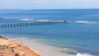
Port Noarlunga is a suburb in the City of Onkaparinga, South Australia. It is a small sea-side suburb, with a population of 2,918, about 30 kilometres to the south of the Adelaide city centre and was originally created as a sea port. This area is now popular as a holiday destination or for permanent residents wishing to commute to Adelaide or work locally. There is a jetty that connects to a 1.6 kilometres long natural reef that is exposed at low tide. The beach is large and very long and has reasonable surfing in the South Port area whose name is taken from its location - "South of the Port".

Tjilbruke is an important creation ancestor for the Kaurna people of the Adelaide plains in the Australian state of South Australia. Tjilbruke was a Kaurna man, who appeared in Kaurna Dreaming dating back about 11,000 years. The Tjilbruke Dreaming Track or Tjilbruke Dreaming Trail is a major Dreaming trail, which connects sites from within metropolitan Adelaide southwards as far as Cape Jervis, some of which are Aboriginal sacred sites of great significance.

Christies Beach is a seaside suburb in the southern Adelaide metropolitan area, within the City of Onkaparinga. The area is scenic and hence popular with photographers as Witton Bluff provides a natural vantage point over the entire suburb and beyond.

Surf art is visual art about or related to the sport of surfing, waves, and the culture that surrounds beaches.

Tapleys Hill Road is a north–south arterial road which runs parallel to the coast through western Adelaide, Australia. This name covers many consecutive streets and is not widely known to most drivers except for the northernmost section, as the entire allocation is still best known as by the names of its constituent parts: Tapleys Hill Road proper, Brighton Road, Ocean Boulevard, Lonsdale Road, Dyson Road, Murray Road, and Gawler Street. This article will deal with the entire length of the corridor for sake of completion, as well to avoid confusion between declarations.
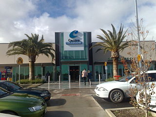
Noarlunga Centre is a suburb in the City of Onkaparinga in the southern suburbs of Adelaide, South Australia. The suburb is mostly commercial, being dominated by the Centro Colonnades shopping centre and the small 'Inspire Noarlunga' estate to the east of Goldsmith Road. The suburb is bordered by Beach Road to the north, Dyson Road to the west Goldsmith Road to the south and the Southern Expressway to the east. Burgess Drive, Seaman Road and David Witton Drive are the main thoroughfares inside the boundaries of the suburb.

Moana is an outer coastal suburb in the south of Adelaide, South Australia. The suburb is approximately 36.4 km from the Adelaide city centre. It lies within the City of Onkaparinga local government area, and neighbours the suburbs Seaford, Maslin Beach, Seaford Rise and Port Noarlunga It is divided into two by Pedler Creek and the associated sand dune reserve. The beach is often referred to as Moana Beach.
Seaford is a metropolitan suburb of Adelaide, South Australia. It lies within the City of Onkaparinga. Seaford railway station is the southern terminus of the Seaford railway line from Adelaide railway station.
Port Noarlunga South is a suburb in the Australian state of South Australia located in the Adelaide metropolitan area on the coastline of Gulf St Vincent about 30 kilometres south of the state capital of Adelaide.
Southern Times Messenger is a weekly suburban newspaper in Adelaide, part of the Messenger Newspapers group. The Southern Times' area stretches from Lonsdale in the north, through to Sellicks Beach in the south, and covers the southern suburbs, accessible from the city via Main South Road and the more recently constructed Southern Expressway. The newspaper generally reports on events of interest in its distribution area, including the suburbs of Morphett Vale, Noarlunga, Reynella and Aldinga. It also covers the City of Onkaparinga council. It has a circulation of 57,690 and a readership of 95,000.
Port Noarlunga Reef Aquatic Reserve is a marine protected area in the Australian state of South Australia located in waters in Gulf St Vincent adjoining the Adelaide metropolitan area and including part of the Onkaparinga River about 28 kilometres (17 mi) south-west of the state capital of Adelaide.
The District Council of Willunga, was a local government area in South Australia seated at Willunga from 1853 until 1997.

The Hundred of Noarlunga is a cadastral unit of hundred in South Australia covering the far south-western Adelaide metropolitan area south and west of the Sturt River and north and west of the Onkaparinga River. It is one of the eleven hundreds of the County of Adelaide stretching from Glenelg in the northwest to Port Noarlunga in the southwest; and spanning inland between the Sturt and Onkaparinga to Bridgewater in the Adelaide foothills. It was named in 1846 by Governor Frederick Robe, Noarlunga being likely derived from 'nurlongga', an indigenous word referring to the curvature in the Onkaparinga River at Old Noarlunga, dubbed Horseshoe Bend by European settlers.
References
- ↑ "Celebrating surfing through art". Radio Adelaide. 11 December 2019. Retrieved 30 January 2020.
- ↑ "Surfboard world record smashed". NewsComAu. 16 December 2013. Retrieved 21 November 2019.
- ↑ "Surfing history celebrated in south". www.adelaidenow.com.au. 11 December 2013. Retrieved 30 January 2020.
- ↑ "Celebrating surfing through art". Radio Adelaide. 11 December 2019. Retrieved 5 December 2020.
- ↑ Jodiebodie (6 January 2019). "Lupey Loops: A Little Splash of the Surf Art Exhibition". Lupey Loops. Retrieved 21 November 2019.
- ↑ "Surf Art Exhibition 2019 Terms & Conditions" (PDF). Retrieved 22 November 2019.