A GIS file format is a standard for encoding geographical information into a computer file, as a specialized type of file format for use in geographic information systems (GIS) and other geospatial applications. Since the 1970s, dozens of formats have been created based on various data models for various purposes. They have been created by government mapping agencies, GIS software vendors, standards bodies such as the Open Geospatial Consortium, informal user communities, and even individual developers.
GeoTIFF is a public domain metadata standard which allows georeferencing information to be embedded within a TIFF file. The potential additional information includes map projection, coordinate systems, ellipsoids, datums, and everything else necessary to establish the exact spatial reference for the file. The GeoTIFF format is fully compliant with TIFF 6.0, so software incapable of reading and interpreting the specialized metadata will still be able to open a GeoTIFF format file.
GeoTools is a free software (LGPL) GIS toolkit for developing standards compliant solutions. It provides an implementation of Open Geospatial Consortium (OGC) specifications as they are developed. GeoTools is a contributor to the GeoAPI project - a vendor-neutral set of Java interfaces derived from OGC specifications - and implements a subset of those.
A GIS software program is a computer program to support the use of a geographic information system, providing the ability to create, store, manage, query, analyze, and visualize geographic data, that is, data representing phenomena for which location is important. The GIS software industry encompasses a broad range of commercial and open-source products that provide some or all of these capabilities within various information technology architectures.
GRIB is a concise data format commonly used in meteorology to store historical and forecast weather data. It is standardized by the World Meteorological Organization's Commission for Basic Systems, known under number GRIB FM 92-IX, described in WMO Manual on Codes No.306. Currently there are three versions of GRIB. Version 0 was used to a limited extent by projects such as TOGA, and is no longer in operational use. The first edition is used operationally worldwide by most meteorological centers, for Numerical Weather Prediction output (NWP). A newer generation has been introduced, known as GRIB second edition, and data is slowly changing over to this format. Some of the second-generation GRIB are used for derived product distributed in Eumetcast of Meteosat Second Generation. Another example is the NAM model.
A Web Map Service (WMS) is a standard protocol developed by the Open Geospatial Consortium in 1999 for serving georeferenced map images over the Internet. These images are typically produced by a map server from data provided by a GIS database.

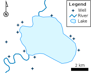
The shapefile format is a geospatial vector data format for geographic information system (GIS) software. It is developed and regulated by Esri as a mostly open specification for data interoperability among Esri and other GIS software products. The shapefile format can spatially describe vector features: points, lines, and polygons, representing, for example, water wells, rivers, and lakes. Each item usually has attributes that describe it, such as name or temperature.
MrSID is an acronym that stands for multiresolution seamless image database. It is a file format developed and patented by LizardTech for encoding of georeferenced raster graphics, such as orthophotos.

QGIS is a free and open-source cross-platform desktop geographic information system (GIS) application that supports viewing, editing, printing, and analysis of geospatial data.
The Open Source Geospatial Foundation (OSGeo), is a non-profit non-governmental organization whose mission is to support and promote the collaborative development of open geospatial technologies and data. The foundation was formed in February 2006 to provide financial, organizational and legal support to the broader Free and open-source geospatial community. It also serves as an independent legal entity to which community members can contribute code, funding and other resources.

The Geospatial Data Abstraction Library (GDAL) is a computer software library for reading and writing raster and vector geospatial data formats, and is released under the permissive X/MIT style free software license by the Open Source Geospatial Foundation. As a library, it presents a single abstract data model to the calling application for all supported formats. It may also be built with a variety of useful command line interface utilities for data translation and processing. Projections and transformations are supported by the PROJ library.
JTS Topology Suite is an open-source Java software library that provides an object model for Euclidean planar linear geometry together with a set of fundamental geometric functions. JTS is primarily intended to be used as a core component of vector-based geomatics software such as geographical information systems. It can also be used as a general-purpose library providing algorithms in computational geometry.
MapServer is an open-source development environment for building spatially enabled internet applications, built in the C language, and is widely known as one of the fastest Web mapping engines available. It can run as a CGI program or via MapScript which supports several programming languages. MapServer can access hundreds of data formats, any raster or vector format supported by GDAL, and reprojections on-the-fly are handled by PROJ. MapServer was originally developed by Steve Lime, then working at the University of Minnesota — so, it was previously referred to as "UMN MapServer", to distinguish it from commercial "map servers"; today it is commonly referred to as just "MapServer", and is maintained by the MapServer Project Steering Committee (PSC). MapServer was originally developed with support from NASA, which needed a way to make its satellite imagery available to the public.
Integrated Land and Water Information System (ILWIS) is a geographic information system (GIS) and remote sensing software for both vector and raster processing. Its features include digitizing, editing, analysis and display of data, and production of quality maps. ILWIS was initially developed and distributed by ITC Enschede in the Netherlands for use by its researchers and students. Since 1 July 2007, it has been released as free software under the terms of the GPL-2.0-only license. Having been used by many students, teachers and researchers for more than two decades, ILWIS is one of the most user-friendly integrated vector and raster software programmes currently available. ILWIS has some very powerful raster analysis modules, a high-precision and flexible vector and point digitizing module, a variety of very practical tools, as well as a great variety of user guides and training modules all available for downloading. The current version is ILWIS 3.8.6. Similar to the GRASS GIS in many respects, ILWIS is currently available natively only on Microsoft Windows. However, a Linux Wine manual has been released.
A remote sensing software is a software application that processes remote sensing data. Remote sensing applications are similar to graphics software, but they enable generating geographic information from satellite and airborne sensor data. Remote sensing applications read specialized file formats that contain sensor image data, georeferencing information, and sensor metadata. Some of the more popular remote sensing file formats include: GeoTIFF, NITF, JPEG 2000, ECW, MrSID, HDF, and NetCDF.

Opticks is a remote sensing application that supports imagery, video, synthetic aperture radar (SAR), multi-spectral, hyper-spectral, and other types of remote sensing data. Opticks supports processing remote sensing video in the same manner as it supports imagery, which differentiates it from other remote sensing applications. Opticks was initially developed by Ball Aerospace & Technologies Corp. and other organizations for the United States Intelligence Community. Ball Aerospace open sourced Opticks hoping to increase the demand for remote sensing data and broaden the features available in existing remote sensing software. The Opticks software and its extensions are developed by over twenty different organizations, and over two hundred users are registered users at http://opticks.org. Future planned enhancements include adding the ability to ingest and visualize lidar data, as well as a three-dimensional (3-D) visualization capability.
NetCDF is a set of software libraries and self-describing, machine-independent data formats that support the creation, access, and sharing of array-oriented scientific data. The project homepage is hosted by the Unidata program at the University Corporation for Atmospheric Research (UCAR). They are also the chief source of netCDF software, standards development, updates, etc. The format is an open standard. NetCDF Classic and 64-bit Offset Format are an international standard of the Open Geospatial Consortium.

In computer science, Orfeo Toolbox (OTB) is a software library for processing images from Earth observation satellites.
Dragon is a remote sensing image processing software package. This software provides capabilities for displaying, analyzing, and interpreting digital images from earth satellites and raster data files that represent spatially distributed data. All the Dragon packages are derived from the code created by Goldin-Rudahl.
PCI Geomatica is a remote sensing and photogrammetry desktop software package for processing earth observation data, designed by the PCI Geomatics company. The latest version of the software is Geomatica 2018. Geomatica is aimed primarily at faster data processing and allows users to load satellite and aerial imagery where advanced analysis can be performed. Geomatica has been used by many educational institutions and scientific programs throughout the world to analyze satellite imagery and trends, such as the GlobeSAR Program, a program which was carried out by the Canada Centre for Remote Sensing in the 1990s.


