Open Spaces Society

Last updated

The Open Spaces Society is a campaign group that works to protect public rights of way and open spaces in the United Kingdom, such as common land and village greens. It is Britain's oldest national conservation body and a registered charity.

Contents

Hampstead Heath 01DVG HAMPSTEAD HEATH EXTENSION.jpg
Hampstead Heath

Founding

The society was founded as the Commons Preservation Society and merged with the National Footpaths Society in 1899, becoming the Commons and Footpaths Preservation Society. It later renamed itself the Commons, Open Spaces and Footpaths Preservation Society, before adopting the present name.

An early example of direct action taken by the society was its overnight removal of two miles of railings that enclosed Berkhamsted common in 1866 with the aid of 120 people. The society also campaigned for the creation of the National Trust. [1]

Its founders and early members included John Stuart Mill, Lord Eversley, William Morris, Sir Robert Hunter, and Octavia Hill. The last two founded the National Trust in 1895 along with Canon Rawnsley. Lord Eversley, as George Lefevre, was a Liberal member of parliament and became a junior minister at the Board of Trade in Gladstone’s government. He held other posts, including Commissioner of Works, and opened Hampton Court Park, Kew Gardens and Regent’s Park to the public. [2]

Subsequent growth

Over the last century and a half the Society has preserved commons for the enjoyment of the public. It has also been active in protecting the historical and vital rights-of-way network through England and Wales. Its early successes included saving Hampstead Heath from gravel extraction, Epping Forest, Wimbledon Common, Ashdown Forest, and the Malvern Hills. After both world wars the society’s difficult task was to reinstate much common land which had been used for defence and food production. [2]

In the late 1960s, following the enactment of the Commons Registration Act 1965, the Open Spaces Society worked hard to register common land and common rights. [2]

Function

The stated objectives of the Society are: [2]

Much of the Open Spaces Society's work is concerned with the preservation and creation of public paths. The word 'footpaths' was included in the Society’s title after it amalgamated with the National Footpaths Preservation Society in 1899. Before the introduction of official maps of public paths in the early 1950s, the public did not know where paths were, and the Open Spaces Society helped the successful campaign for paths to be shown on Ordnance Survey maps. Its work also includes helping to protect common land, town and village greens, open spaces and public paths. It advises the Department for Environment, Food and Rural Affairs and National Assembly for Wales on applications for works on common land. Local authorities are legally required to consult the Society whenever there is a proposal to alter the route of a public right of way. To facilitate part of its charitable aims, the Open Spaces Society is active in other areas; it has representatives on government working parties, national bodies, and more localised bodies.[ citation needed ] It also has some of its members representing it as local correspondents in various parts of the country. [2]

Today, the Society has its headquarters in Henley-on-Thames in Oxfordshire. It has over 2,600 members throughout England and Wales. [2] It publishes a members' magazine Open Spaces, with three issues per year. [3]

Countryside and Rights of Way Act 2000

In 1986, the "Common Land Forum", comprising all the interests in common land, recommended that there should be a public right to walk on all commons in England and Wales, coupled with management of the land. (All commons have a landowner, ranging from a public body to a private individual.) The then government backed the forum’s proposals for legislation and promised to introduce such a law – but did not. More than a decade later, with the Open Spaces Society's help the right was won under the Countryside and Rights of Way Act 2000, to walk on all those commons which previously had no access, subject to certain restrictions. [2]

Supreme Court decisions

On 11 December 2019, a Supreme Court of the United Kingdom decision raised concerns at the society. [4] The primary case involved 13 hectares of land in south Lancaster, the Mooreside Fields, owned by Lancashire County Council. The land had been available for public use for over 50 years. According to the Commons Act 2006, land used for informal recreation for at least 20 years can be registered as a green and is then protected from development. (The Growth and Infrastructure Act 2013 specified that land designated for planning applications could not be registered as a village green, but that did not apply in the Moorside Fields case.)

The Moorside Fields Community Group attempted to register the lands in 2016 under the Commons Act. The local authority challenged the registration, wanting to retain control of the lands for future expansion of the nearby Moorside Primary School's playing fields. The council's challenge failed in the High Court and then in the Court of Appeal; the registration of the land as a village green could proceed. [5] Lancashire County Council subsequently appealed to the Supreme Court of the United Kingdom.

In the appeal decision, cited as R (on the application of Lancashire County Council) (Appellant) v Secretary of State for the Environment, Food and Rural Affairs (Respondent) the Supreme Court overturned the previous judgments. At the same time, the court also ruled against the registration of lands in a separate case in Surrey involving the 2.9 hectare Leach Grove Wood at Leatherhead, owned by the National Health Service. [6] [7] After publication of the decision in the Moorside Fields case, Lancashire County Council told the news media that the court had "protect[ed] this land for future generations". [4]

In effect, the Supreme Court decision left lands owned by public authorities by their statutory powers open to development for any purpose that they deem to be appropriate. [8] This could have far-reaching ramifications in England and Wales, according to the Open Spaces Society. [9]

Related Research Articles

<span class="mw-page-title-main">Village green</span> Common open area within a settlement

A village green is a common open area within a village or other settlement. Historically, a village green was common grassland with a pond for watering cattle and other stock, often at the edge of a rural settlement, used for gathering cattle to bring them later on to a common land for grazing. Later, planned greens were built into the centres of villages.

<span class="mw-page-title-main">Footpath</span> Thoroughfare for pedestrians

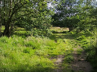
A footpath is a type of thoroughfare that is intended for use only by pedestrians and not other forms of traffic such as motorized vehicles, bicycles and horses. They can be found in a wide variety of places, from the centre of cities, to farmland, to mountain ridges. Urban footpaths are usually paved, may have steps, and can be called alleys, lanes, steps, etc.

<span class="mw-page-title-main">Rights of way in England and Wales</span> Overview of the rights of way in England and Wales

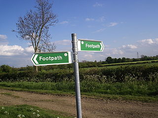
In England and Wales, excluding the 12 Inner London boroughs and the City of London, the right of way is a legally protected right of the public to pass and re-pass on specific paths. The law in England and Wales differs from Scots law in that rights of way exist only where they are so designated, whereas in Scotland any route that meets certain conditions is defined as a right of way, and in addition, there is a general presumption of access to the countryside. Private rights of way or easements also exist.

<span class="mw-page-title-main">Wimbledon Common</span> Large open space in Wimbledon, southwest London, England

Wimbledon Common is a large open space in Wimbledon, southwest London. There are three named areas: Wimbledon Common, Putney Heath, and Putney Lower Common, which together are managed under the name Wimbledon and Putney Commons totalling 460 hectares. Putney Lower Common is set apart from the rest of the Common by a minimum of 1 mile of the built-up western end of Putney.

<span class="mw-page-title-main">Common land</span> Land owned collectively

Common land is land owned by a person or collectively by a number of persons, over which other persons have certain common rights, such as to allow their livestock to graze upon it, to collect wood, or to cut turf for fuel.

<span class="mw-page-title-main">Walking in London</span>

Walking is a popular recreational activity in London, despite traffic congestion. There are many streets that provide interesting walks, especially within historic central London, In addition there are attractive commons, parks, canals, and disused railway tracks that provide space for walks. This includes Wimbledon Common, Epping Forest, Hampstead Heath, and the eight Royal Parks: Hyde Park, Regent's Park, Richmond Park, etc. In recent years access to canals and rivers, including the Regent's Canal, and the River Thames has been greatly improved, and as well a number of long-distance walking routes have been created that link green spaces.

<span class="mw-page-title-main">Rivington Pike</span> Hill in Lancashire, England

Rivington Pike is a hill on Winter Hill, part of the West Pennine Moors at Rivington, Chorley in Lancashire, England. The nearest towns are Adlington and Horwich. The land and building are owned and managed by Chorley Council. The Pike Tower is a prominent local landmark and is located at the summit, it is part of Lever Park. The area is popular with hill walkers and for mountain biking.

<span class="mw-page-title-main">Parks and open spaces in the London Borough of Ealing</span>

The London Borough of Ealing, one of the outer London boroughs although not on the periphery, has over 100 parks and open spaces within its boundaries. These include allotments, cemeteries, playgrounds, and golf courses in addition to the larger open spaces such as nature conservation areas.

A parish meeting is a meeting all the electors in a civil parish in England are entitled to attend.

<span class="mw-page-title-main">Rivington</span> Village in Lancashire, England

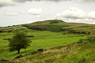
Rivington is a village and civil parish of the Borough of Chorley, Lancashire, England, occupying 2,538 acres. It is about 6 miles (9.7 km) southeast of Chorley and about 8+12 miles (13.7 km) northwest of Bolton. Rivington is a rural area consisting primarily of agricultural grazing land, moorland, with hill summits including Rivington Pike and Winter Hill within the West Pennine Moors. The area has a thriving tourist industry centred around reservoirs created to serve Liverpool in the Victorian era and Lever Park created as a public park by William Lever at the turn of the 20th century, with two converted barns, a replica of Liverpool Castle and open countryside. Rivington and Blackrod High School is located here. Rivington and its village had a population of 109 at the 2011 Census.

<span class="mw-page-title-main">Flixton, Greater Manchester</span> Suburb in Greater Manchester, England

Flixton is a suburb and electoral ward in the Metropolitan Borough of Trafford, Greater Manchester, England. The population of the ward at the 2011 census was 10,786. It lies six miles (9.7 km) southwest of Manchester city centre, in the historic county of Lancashire.

<span class="mw-page-title-main">Warneford Meadow</span>

Warneford Meadow is an area of 20 acres (8.1 ha) of natural grassland immediately south-east of the Warneford Hospital, in Headington, east Oxford, England. The Warneford Meadow is a wild space within urban Oxford. The area has been used by local residents as a public space for recreation for over 50 years.

<span class="mw-page-title-main">Walking in the United Kingdom</span> Aspect of outdoor activities in the UK

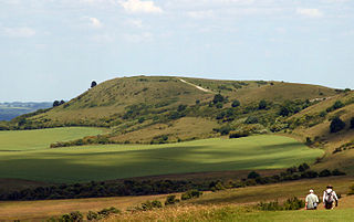
Walking is one of the most popular outdoor recreational activities in the United Kingdom, and within England and Wales there is a comprehensive network of rights of way that permits access to the countryside. Furthermore, access to much uncultivated and unenclosed land has opened up since the enactment of the Countryside and Rights of Way Act 2000. In Scotland the ancient tradition of universal access to land was formally codified under the Land Reform (Scotland) Act 2003. In Northern Ireland, however, there are few rights of way, or other access to land.

<span class="mw-page-title-main">The Ramblers</span> Hikers association in the UK

Ramblers is the trading name of the Ramblers Association Great Britain's leading walking charity. The Ramblers is also a membership organisation with around 100,000 members and a network of volunteers who maintain and protect the path network. The organisation was founded in 1935 and campaigns to keep the British countryside open to all.

<span class="mw-page-title-main">Right of way</span> Legal right to pass through land belonging to another

Right of way is the legal right, established by grant from a landowner or long usage, to pass along a specific route through property belonging to another. A similar right of access also exists on land held by a government, lands that are typically called public land, state land, or Crown land. When one person owns a piece of land that is bordered on all sides by lands owned by others, an easement may exist or might be created so as to initiate a right of way through the bordering land.

<span class="mw-page-title-main">Woodcock Hill Village Green</span>

Woodcock Hill Village Green or Woodcock Hill Open Space is an area of grass and woodland in Borehamwood in Hertfordshire in England. It was designated a Village Green in 2008 to prevent development of the site.

<span class="mw-page-title-main">Commons Registration Act 1965</span> United Kingdom legislation

The Commons Registration Act 1965 is an Act of Parliament in the United Kingdom enacted in 1965 that concerns the registration of rights to common land, town greens, and village greens in England and Wales. The legislation under the Harold Wilson government made reference to the Land Registration Act 1925 and Land Registration Act 1936.

<span class="mw-page-title-main">Richmond, Petersham and Ham Open Spaces Act 1902</span> United Kingdom legislation

The Richmond, Petersham and Ham Open Spaces Act 1902 was enacted to protect the view from Richmond Hill, London.

The law of Illinois consists of several levels, including constitutional, statutory, and regulatory law, as well as case law and local law. The Illinois Compiled Statutes (ILCS) form the general statutory law.

<span class="mw-page-title-main">Ham Common, London</span> Common land in London

Ham Common is an area of common land in Ham, London. It is a conservation area in, and managed by, the London Borough of Richmond upon Thames. It comprises 48.69 hectares, the second largest area of common land in the borough, 2 acres (0.81 ha) smaller than Barnes Common. It is divided into two distinct habitats, grassland and woodland, separated by the A307, Upper Ham Road. It is an area of ecological, historical and recreational interest, designated a Local Nature Reserve.

References

  1. Peter Barberis; John McHugh; Mike Tyldesley (2000). Encyclopedia of British and Irish Political Organizations: Parties, Groups and Movements of the 20th Century. A&C Black. ISBN   978-0-8264-5814-8.
  2. 1 2 3 4 5 6 7 Open Spaces Society
  3. "Publications". Open Spaces Society. 31 August 2017. Retrieved 9 May 2021.
  4. 1 2 "'Village green' land at risk after ruling by supreme court". The Guardian. 14 December 2019. Retrieved 15 December 2019.
  5. "'Village green' land at risk after ruling by supreme court". Lancaster Guardian. 24 April 2018. Retrieved 15 December 2019. The future of a Lancaster village green has been secured after its registration was upheld in court.
  6. "Village Greens In The Balance Warns Open Spaces Society". Society of Local Council Clerks. 11 July 2019. Retrieved 15 December 2019. The question common to both cases was whether the fact that the land was held by a public body for the performance of its statutory powers and duties (by Lancashire County Council and the NHS in these instances) made the land incapable of being registered as a town or village green. Registration requires local people to have used the land for informal recreation for 20 years 'as of right', ie without being stopped or asking permission.
  7. "Supreme Court allows appeals by land-owning public bodies in dispute over statutory incompatibility and village green registration". Local Government Lawyer. 11 December 2019. Retrieved 15 December 2019. [2019] UKSC 58
  8. "WBD advises NHS Property Services on Supreme Court win for village green case". Womble Bond Dickinson. 11 December 2019. Retrieved 15 December 2019. the case has wide implications for land held for statutory purposes by public authorities.
  9. "'Village green' land at risk after ruling by supreme court". The Guardian. 14 December 2019. Retrieved 15 December 2019. I think that this judgment totally redefines the way we understand land held in the public domain," Bebbington said. "It affects every piece of land held by a statutory body, for example by the MoD, the NHS and local authorities.