An urban growth boundary, or UGB, is a regional boundary, set in an attempt to control urban sprawl by, in its simplest form, mandating that the area inside the boundary be used for urban development and the area outside be preserved in its natural state or used for agriculture. Legislating for an "urban growth boundary" is one way, among many others, of managing the major challenges posed by unplanned urban growth and the encroachment of cities upon agricultural and rural land.

Protected areas or conservation areas are locations which receive protection because of their recognized natural, ecological or cultural values. There are several kinds of protected areas, which vary by level of protection depending on the enabling laws of each country or the regulations of the international organizations involved. Generally speaking though, protected areas are understood to be those in which human presence or at least the exploitation of natural resources is limited.

A park is an area of natural, semi-natural or planted space set aside for human enjoyment and recreation or for the protection of wildlife or natural habitats. Urban parks are green spaces set aside for recreation inside towns and cities. National parks and country parks are green spaces used for recreation in the countryside. State parks and provincial parks are administered by sub-national government states and agencies. Parks may consist of grassy areas, rocks, soil and trees, but may also contain buildings and other artifacts such as monuments, fountains or playground structures. Many parks have fields for playing sports such as baseball and football, and paved areas for games such as basketball. Many parks have trails for walking, biking and other activities. Some parks are built adjacent to bodies of water or watercourses and may comprise a beach or boat dock area. Urban parks often have benches for sitting and may contain picnic tables and barbecue grills.
A green belt is a policy and land-use zone designation used in land-use planning to retain areas of largely undeveloped, wild, or agricultural land surrounding or neighboring urban areas. Similar concepts are greenways or green wedges, which have a linear character and may run through an urban area instead of around it. In essence, a green belt is an invisible line designating a border around a certain area, preventing development of the area and allowing wildlife to return and be established.
Land-use planning is the process of regulating the use of land by a central authority. Usually, this is done in an effort to promote more desirable social and environmental outcomes as well as a more efficient use of resources. More specifically, the goals of modern land-use planning often include environmental conservation, restraint of urban sprawl, minimization of transport costs, prevention of land use conflicts, and a reduction in exposure to pollutants. In the pursuit of these goals, planners assume that regulating the use of land will change the patterns of human behavior, and that these changes are beneficial. The first assumption, that regulating land-use changes the patterns of human behavior is widely accepted. However, the second assumption - that these changes are beneficial - is contested, and depends on the location and regulations being discussed.
Greenspace or green space may refer to:
Landscape planning is a branch of landscape architecture. According to Erv Zube (1931–2002) landscape planning is defined as an activity concerned with developing landscaping amongst competing land uses while protecting natural processes and significant cultural and natural resources. Park systems and greenways of the type designed by Frederick Law Olmsted are key examples of landscape planning. Landscape designers tend to work for clients who wish to commission construction work. Landscape planners analyze broad issues as well as project characteristics which constrain design projects.

Sustainable landscape architecture is a category of sustainable design concerned with the planning and design of the built and natural environments.

This article shows the notable future developments in Singapore. Most developments are found in the Downtown Core of Singapore. Majority of them are currently under construction with most to be completed within the next five years.
Conservation development, also known as conservation design, is a controlled-growth land use development that adopts the principle for allowing limited sustainable development while protecting the area's natural environmental features in perpetuity, including preserving open space landscape and vista, protecting farmland or natural habitats for wildlife, and maintaining the character of rural communities. A conservation development is usually defined as a project that dedicates a minimum of 50 percent of the total development parcel as open space. The management and ownership of the land are often formed by the partnership between private land owners, land-use conservation organizations and local government. It is a growing trend in many parts of the country, particularly in the Western United States. In the Eastern United States, conservation design has been promoted by some state and local governments as a technique to help preserve water quality.
Urban, city, or town planning is the discipline of planning which explores several aspects of the built and social environments of municipalities and communities:

The Museum Planning Area is a planning area located in the Central Area of the Central Region of Singapore. The area plays a "bridging role" between the Orchard area and the Downtown Core, which necessitates proper transport networks for vehicles, pedestrians and public transport. Due to the sheer size of green areas in the district, the Urban Redevelopment Authority (URA) has designated it a 'green lung' in the Central Area. However, the Museum Planning Area is also home to cultural and commercial activities. Around 65% of the area is available for future development, making it a hotbed for new infrastructure and buildings.
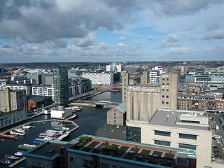
Grand Canal Dock is a Southside area near the city centre of Dublin, Ireland. It is located on the border of eastern Dublin 2 and the westernmost part of Ringsend in Dublin 4, surrounding the Grand Canal Docks, an enclosed harbour where the Grand Canal comes to the River Liffey. The area has undergone significant redevelopment since 2000, as part of the Dublin Docklands area redevelopment project.
South Beach Tower is a commercial and residential complex located on Beach Road in the Downtown Core of Singapore. It is composed of a hotel tower managed by JW Marriott Hotels, an office tower, shops, and residences. The project includes the restoration of four conservation buildings – the former Non-Commissioned Officers' Club building and part of the former Beach Road Camp. It is accessible from Esplanade MRT station.
Reserve is a term of art for some administrative territorial entities and may refer to:

An open space reserve is an area of protected or conserved land or water on which development is indefinitely set aside.
An urban planner is a professional who practices in the field of urban planning.

The Paddington Reservoir is a heritage-listed public park located at 255a Oxford Street in the inner eastern Sydney suburb of Paddington in the City of Sydney local government area of New South Wales, Australia. It was designed by Edward Bell and built from 1864 to 1866 and operated as a water reservoir which accepted water from the Botany Swamps pumping station for supply to parts of Sydney between 1866 and 1899. In the twentieth century the site variously functioned as a service station and storage and mechanical workshop site. In 2006 work commenced to convert the site into a sunken garden and park. It is also known as Walter Read Reserve; Paddington Reservoir Gardens; Reservoir Gardens. The property is owned by City of Sydney. It was added to the New South Wales State Heritage Register on 2 April 1999.

Mount Carmel National Park is Israel's largest national park, extending over most of the Carmel mountain range and containing over 10,000 hectares of pine, eucalyptus, and cypress forest. The park has numerous bicycle and walking paths, dedicated nature reserves, and over 250 archaeological sites of prehistoric human habitations.