Related Research Articles

A dry dock is a narrow basin or vessel that can be flooded to allow a load to be floated in, then drained to allow that load to come to rest on a dry platform. Dry docks are used for the construction, maintenance, and repair of ships, boats, and other watercraft.

A pontoon bridge, also known as a floating bridge, uses floats or shallow-draft boats to support a continuous deck for pedestrian and vehicle travel. The buoyancy of the supports limits the maximum load that they can carry.
A floating dock, floating pier or floating jetty is a platform or ramp supported by pontoons. It is usually joined to the shore with a gangway. The pier is usually held in place by vertical poles referred to as pilings, which are embedded in the seafloor or by anchored cables. Frequently used in marinas, this type of pier maintains a fixed vertical relationship to watercraft secured to it, independent of tidal, river or lake elevation. The angle of the gangway varies with the water level.
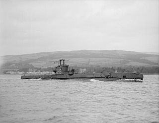
HMS Sceptre (P215) was a third-batch S-class submarine built for the Royal Navy during World War II. Completed in April 1943, she spent the majority of her career in the North Sea, off Norway. After an uneventful patrol, the submarine participated in Operation Source, an attack on German battleships in Norway using small midget submarines to penetrate their anchorages and place explosive charges. However, the midget submarine that she was assigned to tow experienced technical difficulties and the mission was aborted. During her next four patrols, Sceptre attacked several ships, but only succeeded in severely damaging one. She was then ordered to tow the submarine X24, which was to attack a floating dry dock in Bergen. The operation, codenamed Guidance, encountered difficulties with the attacking submarine's charts, and the explosives were laid on a merchant ship close to the dock instead. The dock was damaged and the ship sunk, and X24 was towed back to England. Sceptre then conducted a patrol in the Bay of Biscay, sinking two German merchant ships, before being reassigned to tow X24 to Bergen again. The operation was a success, and the dry dock was sunk.

Seeadler Harbor, also known as Port Seeadler, is located on Manus Island, Admiralty Islands, Papua New Guinea and played an important role in World War II. In German, "Seeadler" means sea eagle, pointing to German colonial activity between 1884 and 1919 in that area. The bay was named in 1900 after the German cruiser SMS Seeadler.

The X class was a World War II midget submarine class built for the Royal Navy during 1943–44. It was substantially larger than the original Chariot manned torpedo.

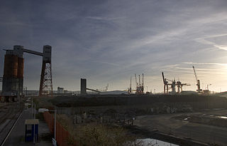
Bristol Harbour is the harbour in the city of Bristol, England. The harbour covers an area of 70 acres. It is the former natural tidal river Avon through the city but was made into its current form in 1809 when the tide was prevented from going out permanently. A tidal by-pass was dug for 2 miles through the fields of Bedminster for the river, known as the "River Avon New Cut", "New Cut", or simply "The Cut". It is often called the Floating Harbour as the water level remains constant and it is not affected by the state of the tide on the river in the Avon Gorge, The New Cut or the natural river southeast of Temple Meads to its source.

Garden Island is an inner-city locality of Sydney, Australia, and the location of a major Royal Australian Navy (RAN) base. It is located to the north-east of the Sydney central business district and juts out into Port Jackson, immediately to the north of the suburb of Potts Point. Used for government and naval purposes since the earliest days of the colony of Sydney, it was originally a completely-detached island but was joined to the Potts Point shoreline by major land reclamation work during World War II.
AFD or AfD may refer to:

The Port of Bristol comprises the commercial, and former commercial, docks situated in and near the city of Bristol in England. The Port of Bristol Authority was the commercial title of the Bristol City, Avonmouth, Portishead and Royal Portbury Docks when they were operated by Bristol City Council, which ceased trade when the Avonmouth and Royal Portbury Docks were leased to The Bristol Port Company in 1991.
The Avonmouth Docks are part of the Port of Bristol, in England. They are situated on the northern side of the mouth of the River Avon, opposite the Royal Portbury Dock on the southern side, where the river joins the Severn estuary, within Avonmouth.

His Majesty's Naval Base, Singapore, also Her Majesty's Naval Base, Singapore, alternatively known as the Singapore Naval Base, Sembawang Naval Base and HMS Sembawang, was situated in Sembawang at the northern tip of Singapore and was both a Royal Navy shore establishment and a cornerstone of British defence policy in the Far East between the World Wars. From 1921 to 1941 it was a China Station base, from 1941 to 1945 a repair facility for the Imperial Japanese Navy and from 1945 to 1958 a Far East Fleet base. Today, it is a commercial dockyard but British military activity still exists at the British Defence Singapore Support Unit (BDSSU).

The East India Docks were a group of docks in Blackwall, east London, north-east of the Isle of Dogs. Today only the entrance basin and listed perimeter wall remain visible.
Severnaya Verf is a major shipyard on Gutuevsky Island in Saint Petersburg, Russia, producing naval and civilian ships. It was founded as a branch of the Putilov Plant in the late 1800s. Under the Soviets, the shipyard was generally known as Shipyard No. 190 and reverted to its former name in 1989.

The Port of Naples, a port located on the Western coast of Italy, is the 11th largest seaport in Italy having an annual traffic capacity of around 25 million tons of cargo and 500,000 TEU's. It is also serves as a tourist hub, servicing an estimated 10 million people annually transiting through the port.
German submarine U-205 was a Type VIIC U-boat of the Kriegsmarine during World War II. The submarine was laid down on 19 June 1940 by the Friedrich Krupp Germaniawerft yard at Kiel as yard number 634; launched on 20 March 1941; and commissioned on 3 May 1941 under the command of Franz-Georg Reschke.

Bertha is a steam-powered boat built in 1844 to remove silt from the Port of Bridgwater in Somerset, England. It is the oldest operational steam vessel in Britain, and possibly in the world. It is part of the National Historic Fleet.

German submarine U-993 was a Type VIIC U-boat of Nazi Germany's Kriegsmarine during World War II.

An auxiliary floating drydock is a type of US Navy auxiliary floating dry dock. Floating dry docks are able to submerge underwater and to be placed under a ship in need of repair below the water line. Water is then pumped out of the floating dry dock, raising the ship out of the water. The ship becomes blocked on the deck of the floating dry dock for repair. Most floating dry docks have no engine and are towed by tugboats to their destinations. Floating dry docks come in different sizes to accommodate varying ship sizes, while large floating dry docks come in sections and can be combined to increase their size and lift power. Ballast pontoon tanks are flooded with water to submerge or pumped dry to raise the ship.

SS Bärenfels was a German steam cargo liner that was launched in 1921 for DDG Hansa. In 1940, she took part in the German invasion of Norway and was sunk by Fleet Air Arm dive bombers. Her wreck was raised, and in 1941, she was returned to service. In 1944, a Royal Navy midget submarine sank her, killing 11 of her complement. In 1947, her wreck was raised to be scrapped, but while under tow she sank a third time. The wreck is now a recreational wreck diving site.
References
- ↑ "Far Flung Australians - cutting cables". Ww2australia.gov.au. Archived from the original on 23 June 2017. Retrieved 6 September 2015.